Shadows

Springfield

Silver Member
Apr 19, 2003
2,850
1,387
New Mexico
Detector(s) used
BS
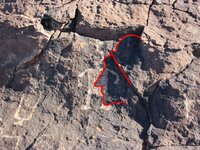
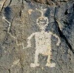
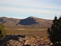
There are shadow signs, but very few. They were used to draw attention to something else - something close by and unmistakable. There should be no guesswork needed, no artistic imagination required. The helmeted soldier below (his shadow outlined) is drawing the viewer's attention to 'Happy Man'. Happy was engraved within the shadow to draw attention to the fact that he is not a native petroglyph like so many others in the near vicinity, but created by the folks who used the shadow. Happy's right arm is a zigzag pointer. When you sight down his arm, you are looking at the zigzag ridgeline in the distance. Go there.

Shadow signs and lookalike rocks were seldom used, but when they were, they were unmistakable and led the viewer quickly to the 'real' sign close by, usually within a stone's throw. These things were used in the olden days when the terrain was unmapped. Most of the carvings and other valid clues you are finding are much more recent - 1930's for many of them (that's right, these are not 'Spanish'), and most are designed to look older. Nearly all the shadows and looky rocks you are posting are natural phenomena.
 

Attachments

  • shadow soldier.JPG
    shadow soldier.JPG
    111.7 KB · Views: 1,077
  • Happy man-3.jpg
    Happy man-3.jpg
    19.8 KB · Views: 1,374
  • Zigzag-2.JPG
    Zigzag-2.JPG
    50.6 KB · Views: 1,256
More at Happy Hill

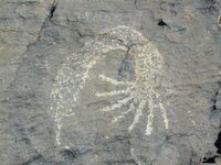
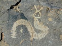
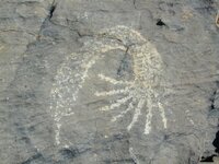
Seven spikes into the earth from the volcano.
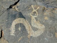
Seven segments on the snake's tail.
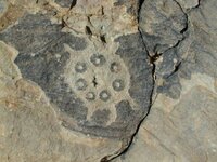
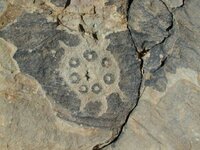
Seven circles on the turtle's shell.

You don't need to guess at it.
 

Attachments

  • Volcano-2.jpg
    Volcano-2.jpg
    41 KB · Views: 1,067
  • snake1-2.jpg
    snake1-2.jpg
    44.7 KB · Views: 1,059
  • Turtle 1-2.jpg
    Turtle 1-2.jpg
    54.3 KB · Views: 1,073
  • Volcano-2.jpg
    Volcano-2.jpg
    41 KB · Views: 1,057
  • snake1-2.jpg
    snake1-2.jpg
    44.7 KB · Views: 1,045
  • Turtle 1-2.jpg
    Turtle 1-2.jpg
    54.3 KB · Views: 1,017
Thanks for the posts and pictures Springfield. Just to make sure I understand, are you saying the shadow signs are used as confirmation for the real signs? Have you ever seen written historical accounts of people making shadow signs or using them on a trail? Would the shadow signs only be used on trails to mines or would there be other circumstances when they would be used?

Thanks again.

Rick
 

mdog said:
Thanks for the posts and pictures Springfield. Just to make sure I understand, are you saying the shadow signs are used as confirmation for the real signs?
In the example provided and others I'm aware of, yes. For all shadow signs, I couldn't say.

mdog said:
Have you ever seen written historical accounts of people making shadow signs or using them on a trail?
No.

mdog said:
Would the shadow signs only be used on trails to mines or would there be other circumstances when they would be used?
I would say they can be used for any purpose desired. IMO, most trail signs were simple and straightforward. We tend to make this topic more esoteric than it needs to be, at least for the small handful of old mines, etc. that were abandoned and marked for later recovery. Some sites, such as the one where the photos were taken, are more complex because of their importance and because of the capabilities of the persons involved. When we move forward, especially to the 1930's and beyond, things get so extremely arcane that the clues are essentially non-decipherable to all but the insiders.

Remember, this forum catagory deals with 'Treasure Signs' presumably created by persons whose intent is to mark the location of hidden things/places of value. The more general topic of shadow signs and geologic pareodolia, especially as used by Native Americans who used the techniques to inspire their petroglyph forms and placements, is beyond the scope of this discussion but was mimicked by a few of the treasure guys to some extent. The whole thing was an artistic/spiritual exercise for the ancients, but was only a camoflage technique for the cachers. My intent with this thread is to remind searchers that if they are tracking an old concealed mine or a cache of valuables (both much rarer than you wish to believe), the bona fide signs left behind are not hard to identify. They are distinct and easy to find - interpreting them is the hard part.
 

Springfield, please be patient with me because I want to make sure I understand what you are saying.

At the spot I'm looking at I always thought there were too many things right out in the open easy to see. After a time, I noticed that there were five pieces of the puzzle that were right out there and easy to see but not easy to notice unless you knew what to look for. I figure that these were the first markers. After that, anything that gave direction was a lot easier to see and it seemed like somebody was leaving carved notes or confirmed formations for either themselves or somebody else that might follow. This period would have been before this territory was settled by the pioneers from the United States. When settlers started moving in from the United States, the area became heavily populated rather quickly. This spot was a prominent landmark so the graffiti became a lot more frequent and had nothing to do with hidden valuables. There are a few markings that could have been outlaw related but not tied in with the original signs. Then I think another group moved in who saw the markings from the second group that were easy to see and notice. I think these guys figured out there was something there and started making their own signs and symbols using the things the second group had left. So over a period of many years the site had changed to the point that there was so much easy stuff to see that the original marks could be easily overlooked. I also think things were added by the last two groups to throw others off the trail. I think this process is ongoing at this place because I still find new things added to the old stuff to change the context of the signs. So at this time, the only people who could come to this site and find the original things and figure out what it means are the guys who set the first site up, or somebody who knows the signs they use.

Is that what you're saying.

Rick
 

mdog said:
Springfield, please be patient with me because I want to make sure I understand what you are saying.

At the spot I'm looking at I always thought there were too many things right out in the open easy to see. After a time, I noticed that there were five pieces of the puzzle that were right out there and easy to see but not easy to notice unless you knew what to look for. I figure that these were the first markers. After that, anything that gave direction was a lot easier to see and it seemed like somebody was leaving carved notes or confirmed formations for either themselves or somebody else that might follow. This period would have been before this territory was settled by the pioneers from the United States. When settlers started moving in from the United States, the area became heavily populated rather quickly. This spot was a prominent landmark so the graffiti became a lot more frequent and had nothing to do with hidden valuables. There are a few markings that could have been outlaw related but not tied in with the original signs. Then I think another group moved in who saw the markings from the second group that were easy to see and notice. I think these guys figured out there was something there and started making their own signs and symbols using the things the second group had left. So over a period of many years the site had changed to the point that there was so much easy stuff to see that the original marks could be easily overlooked. I also think things were added by the last two groups to throw others off the trail. I think this process is ongoing at this place because I still find new things added to the old stuff to change the context of the signs. So at this time, the only people who could come to this site and find the original things and figure out what it means are the guys who set the first site up, or somebody who knows the signs they use.

Is that what you're saying.

Rick

Man, that's a mouthful, mdog. All I can say is that it's naive to assume that any cache of value is ever likely to become 'lost'. The more valuable the stash, the more certain that it's still under control of its owners. Some are ancient, some are old, some have been relocated, some may be recent. Whoever owns the goods knows the secrets. There's not much reason to hide the signs if you are the only one who can read them.
 

Thanks Springfield. I guess I was trying to over analyze what you were saying. :tongue3:
 

Thanks. It is interesting the way they used glyphs. I've grown quite fond of shadows and think their heritage is long both in time and in distance.
 

These things were used in the olden days when the terrain was unmapped

Springfield, is it posible to date a site or determine who set the site up if there are shadow signs being used? Is this technique of sign construction something that would be used by a specific group, Spanish, French, religious, etc. I realize that anybody could use the technique for any reason, but I would like to know if you could figure out who set a site up and when by looking at the signs there.

Thanks,
Rick
 

mdog said:
These things were used in the olden days when the terrain was unmapped

Springfield, is it posible to date a site or determine who set the site up if there are shadow signs being used? Is this technique of sign construction something that would be used by a specific group, Spanish, French, religious, etc. I realize that anybody could use the technique for any reason, but I would like to know if you could figure out who set a site up and when by looking at the signs there.

Thanks,
Rick

My answer would have to be, "No".

The natives used the technique as part and parcel of their spiritual belief system. They often sited petroglyphs in a 'visionary' location in the physical realm to express a 'shadow world' idea.

I would say that bona fide treasure cachers (those who buried, hid, concealed, etc. valuables in order to retrieve later) only very, very, very, very rarely used shadow signs. The 'organization' used(es) them as another tool in their bag of tricks to obfuscate and discourage folks like you and me who think we're going to figure out the clues being located in the field.

By the way, you need to take a cold, hard look at the true extent and scope of activities of those groups you've mentioned. The treasure magazines and various websites, including this one, would have you believe that these guys were finding gold everywhere they went and stacking it like cordwood in nearly every state in the union. They simply were not. There are caches out there, but they aren't 'Spanish'. 'Lost Spanish' is merely easy-to-swallow disinformation.
 

The 'organization' used(es) them as another tool in their bag of tricks to obfuscate and discourage folks like you and me who think we're going to figure out the clues being located in the field.

When you say organization do you mean the merchants, bankers, or corporations who finance the mining and other endeavors and claim their profits in the form of valuable metals or furs or agricultural commodities and livestock? I can understand why such groups would combine their efforts to move large shipments of valuable metals from distant and remote areas. I can also understand that in the days before railroads when mules or oxen were used to transport metals, circumstances might require cache sites along the trail. Is this what you mean? Hope I'm not being a pest but if I'm trying to find the history of the spot I'm looking at, it just got a lot harder if I have to consider such groups. Maybe even impossible.

Another question. Common sense leads me to believe that the military, of whatever country claimed a region, would provide security for such large movements of valuables. So if you have a story of Spanish or Mexicans moving 100 mules loaded with gold through an area, it doesn't necessarily mean that the gold belonged to Spain or Mexico just that Spanish or Mexican troops were responsible for security. Would that be right?

Thanks again.
Rick
 

Every Spanish Mission had a Presidio very close by for the protection of the Priests, padres, etc. So, if you look at a map with the locations of the Missions, you can automatically put a detachment of soldiers close by whether or not that map actually shows as fort.
 

nice pics Steve !
kinda curious about the dot at the end of your Zig Zag , that happy is pointing too.
but you have already shared much . thanks :thumbsup:
 

mdog said:
The 'organization' used(es) them as another tool in their bag of tricks to obfuscate and discourage folks like you and me who think we're going to figure out the clues being located in the field.

When you say organization do you mean the merchants, bankers, or corporations who finance the mining and other endeavors and claim their profits in the form of valuable metals or furs or agricultural commodities and livestock? .....

The valuable assets were converted to precious metals and concealed. The assets came from many sources - recovered caches, mining ventures, legitimate commerce of all kinds, thievery, etc. The gold/silver (universal money) was then cached for later use. IMO.

mdog said:
Another question. Common sense leads me to believe that the military, of whatever country claimed a region, would provide security for such large movements of valuables. So if you have a story of Spanish or Mexicans moving 100 mules loaded with gold through an area, it doesn't necessarily mean that the gold belonged to Spain or Mexico just that Spanish or Mexican troops were responsible for security. Would that be right?

Thanks again.
Rick

In one way or another, all militaries are mercenaries for the elite. Sometimes they wear a soveriegn country's colors, sometimes they don't. Private armies have never been hard to form when there was a reason for doing so and there was money to pay for it. It all depends on who's pulling the strings.
 

kanabite said:
nice pics Steve !
kinda curious about the dot at the end of your Zig Zag , that happy is pointing too.
but you have already shared much . thanks :thumbsup:

Yeah, that dot is a curiosity. I honestly don't know the true answer.
 

charliejr said:
It may be possible to reverse engineer the group that used "shadows as signs". Spanish -non Jesuit- may have used time and placement minus religious syntax. However, Jesuit may have used certain houses of the sky to denote religious oriented dates.

Since we are dealing with the Northern Hemisphere, before creation of a "shadow sign", a "sun dial" would first be used to determine the suns highest point in the sky. Also, using the north star, measured upon the horizon, would aid location upon the globe.

The more elaborate the system of signs might speak "Jesuit" because the Jesuits were highly advanced in star cartography, while regular Spanish may only have the basics of navigation.

In order to date a place, or glyph, find; determining the position of stars in relation to the earth and sun can give accurate date as to placement. The only obfuscation that may be relevant is between those who had the knowledge and those who did not. Unless there were inter or intra invested parties bent on thwarting others, 3rd parties with insider information would be highly unlikely.

For simple experimentation, place a stick in the ground at approximated noon hour, study this. Always know the Sun will move from an easterly direction to a westerly direction.

Minus religion or philosophy, using basic math and science, it is more than plausible to arrive at general conclusions you come to upon your observations in the field.

Until the British finally developed an accurate sea chronometer about 200 years ago, it was virtually impossible to determine a true global position closer than a couple hundred miles, even using the most advanced 'star cartography' available. Many tried, all failed - even Columbus, whose calculations were off by about 500 miles during his 1492 voyage. A northing fix (latitude) has always been easy - even a Boy Scout can get acceptable results using homemade instruments. It's the easting fix (longitude) that was the problem because longitude is not related to the earth's relationship to the heavenly bodies. Instead, it's based upon an arbitrary grid of the earth's surface, based on an agreed starting point - Greenwich Mean Meridian currently.

Land surveying position identification (requiring even more accuracy than at sea) didn't achieve acceptable results until the surveyor had access to telegraph signals to establish a control point from which to measure. Spanish land explorers? Forget about it - they didn't know their true global position to within a hundred miles at best, and that's being generous. The early explorers (pre-1800's) had the capability of good line-of-sight local navigational accuracy (azimuths) and varying degrees of local distance measurement accuracy, but that's about it.

We've seen and heard about treasure signs being located that seem to fit patterns of startling accuracy, some being associated with complex three-dimensional layouts, sacred geometry, star chats, etc. This may be true, but if it is, you need to shift your focus to the modern age because that's most likely when these clues were placed. If the Jesuits were in on this stuff, then it happened well after their expulsion from the New World in 1765, because the technology did not exist then to achieve the results being reported. If that's the case, then it raises even more interesting questions.
 

You have a real good thread going here Springfield. I believe the subject is very interesting and you are sharing a lot of good information. Thanks.

Rick
 

cj,
I'm not denying a substantial knowledge of the positions of the heavenly bodies dating back millenia - the evidence is obvious and widespread.

The early navigational and architectural examples you've provided are indisputable. However, the navigational exploits were the result of trial/error, azimuth awareness, ocean current charting, landmark identification and careful record keeping. The architectural feats were accomplished via celestial observation/application. As I mentioned earlier, 'local mapping' (spatial geometry relative to limited line-of-sight venues) is a technique mastered long, long ago.

[Where the ancients acquired their knowledge is beyond the scope of this topic, but deserves an entire catagory of its own, IMO]

The point I'm making is that it was impossible for modern man (ie post Ice Age) to accurately locate a position on the earth's unexplored surface prior to ca 1800. It is impossible to determine exact longitude on the globe without knowing the exact time in Greenwich, London. Many theories were tested for many years trying to use eclipses, movements of Jupiter's moons, etc. to make the calculation. Theoretically it was plausible, but in practicality it was unworkable.

We're really not in disagreement about much here. My allegation is simply that many 'treasure signs' attributed to the 'Spanish era' aren't - they were created beginning in the Southwestern Anglo Era (post Civil War), extending into the 20th Century. Many appeared after 1933.
 

We're really not in disagreement about much here. My allegation is simply that many 'treasure signs' attributed to the 'Spanish era' aren't - they were created beginning in the Southwestern Anglo Era (post Civil War), extending into the 20th Century. Many appeared after 1933.

What happened after 1933? Was there an increase in mining activity? More people wanting to leave their mark?
 

What happened after 1933? Was there an increase in mining activity? More people wanting to leave their mark?

Never mind. Dumb question. Sorry, :BangHead: :tongue3:
 

Top Member Reactions

Users who are viewing this thread

Back
Top