ALewis
Sr. Member
Made it out to mineral bar yesterday on way home from Reno, (got my room upgraded to a suite at the JA Nugget, never happens  )
)
Seems like I am learning new things all the time....my experience on this trip was just how much my trail & gravel bar are effected by the rain we got. about 3/4 of the way to my chosen spot, I get to a "river crossing", wich has never been more than a step and walk across some exposed bedrock. Yesterday was a 6-7 foot wide stretch of running water ! I wouldn't even attempt to wade that part. Crazy to see such a difference after so little rain / snow...
So, after messing around without much success, decided I would head up to Stephens Trail. After some crazy bushwackin, I made it up, and then back down.....only to find the water high enough that my V dam was long gone, and probably under a couple feet of water ! The "good" spot to set-up my sluice was no longer there ! So amazing to see the difference, and this was not even a big storm.
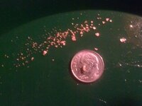
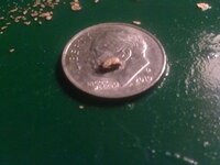
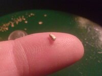
Still have to go through the cons that I brought home, but don't think it will be anything too much. Spent most of my time enjoying the Sun, adventuring & trying not to fall down the cliff
So, all in all, I'd say another successful day on the river !!!
 )
)Seems like I am learning new things all the time....my experience on this trip was just how much my trail & gravel bar are effected by the rain we got. about 3/4 of the way to my chosen spot, I get to a "river crossing", wich has never been more than a step and walk across some exposed bedrock. Yesterday was a 6-7 foot wide stretch of running water ! I wouldn't even attempt to wade that part. Crazy to see such a difference after so little rain / snow...
So, after messing around without much success, decided I would head up to Stephens Trail. After some crazy bushwackin, I made it up, and then back down.....only to find the water high enough that my V dam was long gone, and probably under a couple feet of water ! The "good" spot to set-up my sluice was no longer there ! So amazing to see the difference, and this was not even a big storm.
Still have to go through the cons that I brought home, but don't think it will be anything too much. Spent most of my time enjoying the Sun, adventuring & trying not to fall down the cliff
So, all in all, I'd say another successful day on the river !!!
Amazon Forum Fav 👍
Upvote
0


