Researching

RandyTheKid

Full Member
Mar 16, 2018
231
770
Kentucky
Detector(s) used
Garrett Ace 300
Primary Interest:
All Treasure Hunting
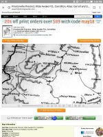
Are the black squares homesteads or just the people who owned the land? I'm thinking they're old homes because right in the middle is a black square right next to a "cem" cemetery with no name attached is my house. Remember this map is from 1883 it shows a trail right next to the cemetery that doesn't exist. Screenshot_20180514-214031.jpg
 

I would think they are, curios were your finding this old of maps at of KY. Ok, i found them. sure wish i could go back that far in my area.
 

Last edited:
The black square that goes with the word "cem" denotes that cemetery. I would guess the names with squares are the "used to be" owners. Family may still own it. Your name isn't there because you (or family) were not there at the time the map was made. Is that what you meant? ╦╦Ç
 

I would think they are, curios were your finding this old of maps at of KY. Ok, i found them. sure wish i could go back that far in my area.

I'm pretty lucky to be honest because there's two old homes that existed on our property. What part of Kentucky are you from?
 

The black square that goes with the word "cem" denotes that cemetery. I would guess the names with squares are the "used to be" owners. Family may still own it. Your name isn't there because you (or family) were not there at the time the map was made. Is that what you meant? ╦╦Ç

Yeah i was wondering if the squares was the property owners or houses that may have existed. I knew the cemetery was there. My grandpa bought the house in the 1970s and some land and wanted to find locations where I could hunt at. Way it looks I have 2 old torn down homes on our land.
 

On the pre-1900 maps here in Illinois, the black squares indicate a structure...usually a house. And our mapmakers were on the money as far as accuracy goes. 😁
 

On the pre-1900 maps here in Illinois, the black squares indicate a structure...usually a house. And our mapmakers were on the money as far as accuracy goes. ��

I just checked out historical aerials and seen a satellite imagery from 1950 and know exactly where a house was once located. Also got to see my house was once a beautiful farm house with fields. Now it's all trees. As for the the trail i seen right by the cemetery, there's an old road they call dump road but it isn't that close to the cemetery. Huge bottle dump that's holding some old bottles from the 50s and 40s
 

Top Member Reactions

Users who are viewing this thread

Latest Discussions

Back
Top