DaytonaRacer
Sr. Member
- May 21, 2013
- 486
- 222
- Detector(s) used
- BH Tracker IV,
Fisher F22,
Garrett Pro Pointer
- Primary Interest:
- Other
Rutgers University in NJ consists of many campus/colleges spread across the state. In the immediate area of the original Queens College sits the Rutgers-New Brunswick campus, Cook College, Douglass College, Busch, and Livingston. Livingston is referred to as the Kilmer Campus because it sits on the former Camp Kilmer army base - a waystation in Piscataway, NJ for soldiers departing for and returning from WWII.
I recently came across a map of Camp Kilmer (CK) - actually, less of a formal map and more of an artist's hand-drawn rendition of the base and all pertinent locations therein - within the informational brochure given to soldiers stationed there. It contains the 10 distinctive zones of the campus, all of the px sites, phones, beer halls, theatres, chapels, Post HQ, libraries, etc. I decided to head over there and see if I could MD at any of the original locations.
Once Rutgers took over the site in 1970, the basic layout remained the same but several of the roads changed names or were abandoned. The university co-opted several of the existing buildings and replaced most others. As a former student there I was familiar with most of the campus but even in the last 10 years it's undergone an even more extensive transformation to the point where I had to double back on some roads several times to figure out where the old roads I once knew were vs. where I was now, never mind where they were on a hand-drawn map from 70 years ago. The 1940's Plainfield Road is now Sutton's Lane. Avenue A is now Joyce Kilmer. Road 1, which I drove down probably over a hundred times, is almost unrecognizable (and half its original length, as is Plainfield).
According to the map, where Plainfield and Avenue 2 used to bisect there had been a px on one side and a library on the other. I climbed into the now-overgrown woods, over the rubble piled on Plainfield 40 years prior to truncate it, and found a 1970's-era handball court, lots of overgrowth, concrete that set my detector off like crazy, and trash. Lots and lots of trash - to the point that I couldn't find anything else. No sign of either former military building. Every other place on the map was now developed into something else, except for 1 area (actually Zone 1, to be precise).
Again there was a ton of trash hidden in the ground, plus the occasional remnants of old service roads barely visible under the weeds and trees. The outer edge of the woods here, though, were being cultivated for wild flowers and within the woods there hadn't been any "official" activity for decades. It was very hard to discriminate out all of the trash in the ground but there was far less of it than in the 1st location I tried and eventually found what I think might have been the site of the beer hall based on anecdotal evidence from the map and what I was digging up. Amongst the buried nails, rusted metal shards, and who-knows-what-else in that direct vicinity I did find 3 very interesting items:
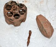
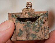
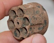
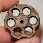
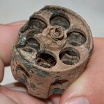
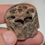
There are no markings on the cylinder, but if someone can identify what gun it likely came from then by all means please let me know. The edge on one end had begun to rot off, but it still has its spring. The cylinder is 1" from front to back, not counting the spring & mount. It's approx. 1-3/8" wide. And the bullet chambers are approx. 5/16" across. Oddly, I could not find the rest of the barrel anywhere nearby. It was buried only a few inches deep.
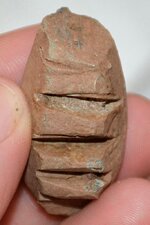
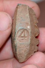
As for the carved object, it looks to me like it's a 4-pound weight that someone started to do some boredom-killing customizing to, but again I'm at a loss as to what it originally was or what the new design was intended it to be.
Thoughts?
I recently came across a map of Camp Kilmer (CK) - actually, less of a formal map and more of an artist's hand-drawn rendition of the base and all pertinent locations therein - within the informational brochure given to soldiers stationed there. It contains the 10 distinctive zones of the campus, all of the px sites, phones, beer halls, theatres, chapels, Post HQ, libraries, etc. I decided to head over there and see if I could MD at any of the original locations.
Once Rutgers took over the site in 1970, the basic layout remained the same but several of the roads changed names or were abandoned. The university co-opted several of the existing buildings and replaced most others. As a former student there I was familiar with most of the campus but even in the last 10 years it's undergone an even more extensive transformation to the point where I had to double back on some roads several times to figure out where the old roads I once knew were vs. where I was now, never mind where they were on a hand-drawn map from 70 years ago. The 1940's Plainfield Road is now Sutton's Lane. Avenue A is now Joyce Kilmer. Road 1, which I drove down probably over a hundred times, is almost unrecognizable (and half its original length, as is Plainfield).
According to the map, where Plainfield and Avenue 2 used to bisect there had been a px on one side and a library on the other. I climbed into the now-overgrown woods, over the rubble piled on Plainfield 40 years prior to truncate it, and found a 1970's-era handball court, lots of overgrowth, concrete that set my detector off like crazy, and trash. Lots and lots of trash - to the point that I couldn't find anything else. No sign of either former military building. Every other place on the map was now developed into something else, except for 1 area (actually Zone 1, to be precise).
Again there was a ton of trash hidden in the ground, plus the occasional remnants of old service roads barely visible under the weeds and trees. The outer edge of the woods here, though, were being cultivated for wild flowers and within the woods there hadn't been any "official" activity for decades. It was very hard to discriminate out all of the trash in the ground but there was far less of it than in the 1st location I tried and eventually found what I think might have been the site of the beer hall based on anecdotal evidence from the map and what I was digging up. Amongst the buried nails, rusted metal shards, and who-knows-what-else in that direct vicinity I did find 3 very interesting items:
- Tiny square-head nails likely used to tack up notices
- Some sort of odd semi-carved object with a "4" on it
- The cylinder from a revolver
There are no markings on the cylinder, but if someone can identify what gun it likely came from then by all means please let me know. The edge on one end had begun to rot off, but it still has its spring. The cylinder is 1" from front to back, not counting the spring & mount. It's approx. 1-3/8" wide. And the bullet chambers are approx. 5/16" across. Oddly, I could not find the rest of the barrel anywhere nearby. It was buried only a few inches deep.
As for the carved object, it looks to me like it's a 4-pound weight that someone started to do some boredom-killing customizing to, but again I'm at a loss as to what it originally was or what the new design was intended it to be.


Thoughts?
Last edited:


