Red River Gorge

EC.Mason

Hero Member
Feb 6, 2009
674
1,041
West Liberty Kentucky
Detector(s) used
Garrett AT Max
Primary Interest:
All Treasure Hunting
Hello, I hope all fellow treasure hunters are doing well! I have researched the Swift mines since I was a kid with my Dad. Most of my research has been in the Elliott County ares since that is where Im from. However I have read a lot in the past about the Red River Gorge and the Swift mines. I truly believe that at least some of his main mines where in that area. I just took a job in Powell County and since being here everytime I pass the Gorge area I get the bug to explore and learn all I can! I have messaged KI since he is from this area, but does anyone else have any information about things that have been found in the Gorge, areas that dont have heavy hiking traffic, and just basic information to help me get started on my research here. I am going to go back through some of our past threads because I know the Gorge area has been discussed a lot. Just wanting to get a jump on my research! Thanks and hope to hear some cool information!!!
 

Good luck with KI, he must be busy with his last find. I haven't seen a post from him in some time.
I do most of my hiking and camping in the RRGorge since about 1979. There is a turkey track on top of Rock Bridge if you want to start somewhere...The Historical marker at the Campton Courthouse is always a good place to start...then go to Rock Bridge and hike down Swift Camp Creek. Mrs. Rebecca Timmin's found an opening she thought was Swift's on the East side of the creek about 1.5-2.0 miles down stream from Rock Bridge and its between the second and third ledge! I found a Indian Trail marker tree just North of the mouth of Swift Camp Creek, details in another thread by that name. There are two Indian stairways, one popular...the other almost unknown. There is a half moon shaped rock by the same name its just not in the right place as the journal puts it. There is an arch called Turtle Back Arch not far from where Mrs. Timmin's spent the rest of her life near said mine opening...On the other end of the gorge there is a haystack rock not far from Indian Creek and Blackburn Branch. Lots of landmarks named for journal descriptions there, many may have been named by Hensen's father who was a USFS employee there in the 1950s and 60s.
 

Last edited:
I forgot to mention, a possible local source for info is in Clay City. The Red River Museum could be a source for local lore. Within these threads I have read about silver bars/tugs found along the banks of Red River (which fork I don't know). The infamous compass and SJM rocks are somewhere along Lower Devils Creek South of the gorge. In the general area where Col. Harrod disappeared in the late 1700s looking for the Swift mine. Gold was 'reported' on a drain off of Mill Creek (now lake) near Natural Bridge S.P. And Boomer found some notes recently that two square molds containing silver and some mule shoes were found behind a waterfall not far from where I found the Indian Trail Tree. I think that was back in the 1800s because he got the info second hand and it was someones grand father or great grand father who found them. There are two Silvermine branches named within the RRGorge, also a Silvermine arch. BTW both of the Silvermine branches are 'off trail' locations. The only way I know to get to them is bushwhacking. If there are any user trails they would be seldom used.
FYI, I would not recommend asking the USFS employees about anything. What they know they won't tell you, and usually they will send you off on a wild goose chase. They tend to be strict on any artifact hunting, metal detecting or ANY digging whatsoever. I mean it is seriously not tolerated at all...
I was told back in the early 1980s while on a prominent bluff with lots of exposed rock by an overtly friendly older man (I was teen) that turkey tracks could be found on almost every overlook out there. Unfortunately he said in the 1960s a lot of hippies who were trying to stop the dam from being built would come to these bluffs and smoke dope (his words not mine) and carve circles around the turkey tracks to make them into peace signs... so if your on a bluff and you see a peace sign, look carefully, it may be a defaced turkey track.
 

Last edited:
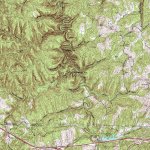
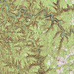
Here are topo maps of Swift Camp Creek. Just North of Campton it passes through private land but then enters the D.B. National Forest (Clifty Wilderness) as it flows Northward. Some of the landmarks I mentioned are on these maps.
SwiftCampCreekTopo1.jpgSwiftCampCreekTopo2.jpg
 

Hello, I hope all fellow treasure hunters are doing well! I have researched the Swift mines since I was a kid with my Dad. Most of my research has been in the Elliott County ares since that is where Im from. However I have read a lot in the past about the Red River Gorge and the Swift mines. I truly believe that at least some of his main mines where in that area. I just took a job in Powell County and since being here everytime I pass the Gorge area I get the bug to explore and learn all I can! I have messaged KI since he is from this area, but does anyone else have any information about things that have been found in the Gorge, areas that dont have heavy hiking traffic, and just basic information to help me get started on my research here. I am going to go back through some of our past threads because I know the Gorge area has been discussed a lot. Just wanting to get a jump on my research! Thanks and hope to hear some cool information!!![/

Ki had moved to Pigeon Forge the last time I talked to him. That’s been almost a year ago. Don’t know if he’s still there or not.
 

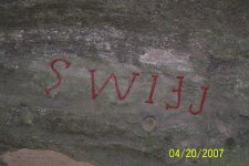
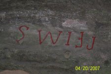
Interesting but probably a fraud carving. Where was this picture taken in the RRGorge?
This looks like it was recently cut spray painted red and then brushed off? Was there something there before and wire brushed away and/or defaced, look around the letters compared to the rest of the rock. Also... smaller donut shaped carving below the 'I' and something faded below the 'W'. There might be something between the inverted 'F' and 'J'.
 

Last edited:
Ok, let us "think on these things"... was the current state of Kentucky part of the COMMONWEALTH of Virginia back then...? Such as Fincastle County, Va. reaching WEST to "OLD MUDDY"; MAYBE part of Botetourt County of Virginia. Swift & Comp. allegedly left from Alexandria, Va., according to some journals... SO! Wanting more Virginians to settle in the "expanded" WESTERN Virginia, LEGENDS of GOLD & SILVER "Mining" could have been used to "incite" & DELIGHT future Frontier families in "GET RICH" schemes...? Enquiring minds wanna KNOW!


In the 1760's they would never carve letters like that, only modern day. Carving letters in rock would not have the straight lines at the ends or beginnings of a letter. To easy to chip the rock and would not last as long as straight letters. Forgery for sure.
 

Ok, let us "think on these things"... was the current state of Kentucky part of the COMMONWEALTH of Virginia back then...? Such as Fincastle County, Va. reaching WEST to "OLD MUDDY"; MAYBE part of Botetourt County of Virginia. Swift & Comp. allegedly left from Alexandria, Va., according to some journals... SO! Wanting more Virginians to settle in the "expanded" WESTERN Virginia, LEGENDS of GOLD & SILVER "Mining" could have been used to "incite" & DELIGHT future Frontier families in "GET RICH" schemes...? Enquiring minds wanna KNOW!

In the 1760s I don't think the Virginia Colony had any claims as far West as where KY is now. The formation of the Transylvania Company came much later. Divine Providence really took hold during the later part of the revolutionary war, and as far as Westward migration and drawing pioneers out beyond the mountains, I didn't think that really kicked in until the Revolution had started (1776)? I am sure rumors and stories of the frontier would be passed around though. Since the area in general was barely explored at that time. Also, the Swift legend doesn't seem to appear until the 1780s.

https://en.wikipedia.org/wiki/History_of_Kentucky
 

Last edited:
In the 1760's they would never carve letters like that, only modern day. Carving letters in rock would not have the straight lines at the ends or beginnings of a letter. To easy to chip the rock and would not last as long as straight letters. Forgery for sure.

Straight lines nor the red paint ! :)
 

In the 1760s I don't think the Virginia Colony had any claims as far West as where KY is now. The formation of the Transylvania Company came much later. Divine Providence really took hold during the later part of the revolutionary war, and as far as Westward migration and drawing pioneers out beyond the mountains, I didn't think that really kicked in until the Revolution had started (1776)? I am sure rumors and stories of the frontier would be passed around though. Since the area in general was barely explored at that time. Also, the Swift legend doesn't seem to appear until the 1780s.

https://en.wikipedia.org/wiki/History_of_Kentucky
GREAT info on Kentucky from wiki; THREE counties created from OLD Virginia...
 

Ok, let us "think on these things"... was the current state of Kentucky part of the COMMONWEALTH of Virginia back then...? Such as Fincastle County, Va. reaching WEST to "OLD MUDDY"; MAYBE part of Botetourt County of Virginia. Swift & Comp. allegedly left from Alexandria, Va., according to some journals... SO! Wanting more Virginians to settle in the "expanded" WESTERN Virginia, LEGENDS of GOLD & SILVER "Mining" could have been used to "incite" & DELIGHT future Frontier families in "GET RICH" schemes...? Enquiring minds wanna KNOW!
Appears that Fincastle County, Va. (Botetourt County, Va.) was "geared" towards SW Virginia & WEST to "Old Muddy"; MANY legends of Swift Mines in that area.
 

HOWEVER, RRG is East Central Kentucky; MAY have been part of OLD Virginia. West Virginia was, until the CONFEDERATE WAR; Gen, Robert E. Lee had a "fave" SALT cave in WV... White Sulfur Springs Cave...? Dunno.
 

Last edited:

Top Member Reactions

Users who are viewing this thread

Back
Top