question on a topographic survey map. (UPDATED JULY 20)

funkman

Bronze Member
Apr 19, 2006
1,062
23
Middletown, NY
Detector(s) used
AT Pro & Ace 250
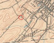
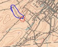
probably the wrong section of the forum but I figured I would get more hits here. Take a look at the attached section of a topographical map that is of my town in 1908. The red circled area is what I want to know about. Looking at the rest of the map I am assuming this used to be a house at this location (the black square). Is this correct? The reason I ask this is because my family walks this road every morning walking the dog and I have always wondered about these 5 trees that are in that spot. The area is overgrown with high grass but naturally the trees stand out. They are very close to the road. I will take a pic of the trees tomorrow morning and post to this post. Looking at this same spot on maps.google.com shows the trees pretty much but I do not see any foundations in the satellite photo to indicate a house was there. I will search through the grass by the trees to see if I can find anything but does this looks like a spot to investigate? I do not know how to get a satellite photo copied to post here to show you what I mean. Any ideas? In fact thinking about it now, those are the only trees in that area for a few hundred feet (except across the street).

Any help from your researchers out there would be appreciated

Funkman
 

Attachments

  • carmelitedrive.jpg
    carmelitedrive.jpg
    62.6 KB · Views: 200
Upvote 0
Re: question on a topographic survey map.

Yes, this appears to be homestead locations as shown on a lot of older maps.
They also had different symbols for churches, schools, and cemeterys usually.

Now, one thing to remember is that the road lacation could very well have changed since this map was drafted.
During construction, the path of the streets are sometimes tweeked or changed altogether. This makes locating older houses a bit of a challenge which actually could be good because anther TH'er may not have located it if it was more difficult.

good luck!
BDoo
 

Re: question on a topographic survey map.

Thanks BDoo. I think the road might be pretty much the way it is excpet obviously that it is paved now (not sure how paving was in 1908). The blue lake and stream that are to the southeast of the circle (if you follow the road SE) are exactly as they are now including the solid balck lines which i takke for dams which are still there also. What should I look for in case the obvious foundation stones are gone. ANy other surface indicators to look for?

Thanks

Funkman
 

Re: question on a topographic survey map.

if theres a chance it was a business you might check out the sanborn fire insurance maps of the city to see if its on it.........g
 

Re: question on a topographic survey map.

Part of your research before actually Th'ing the site could include, enlarging this map and scaling the distances from the adjacent roads on each side, using the modern actual distance as a reference.

Also, scaling from the nearest topo features that are closest to the site. All this could be helpful once you are on site TH'ing.

good luck!

BDoo
 

Re: question on a topographic survey map.

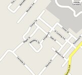
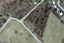
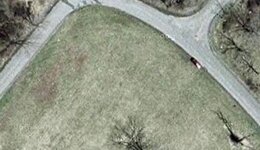
I think I found your site on Google. I tried to post all three pictures, but was too big. I'll try one at a time.

Glenn
 

Attachments

  • map.JPG
    map.JPG
    26.5 KB · Views: 216
Re: question on a topographic survey map.

Picture 2 overall view.
 

Attachments

  • Overall 2.JPG
    Overall 2.JPG
    22.1 KB · Views: 170
Re: question on a topographic survey map.

you cant always see evidence of the old homestead on a satelite photo, or even in person. sometimes there is no foundation left to be seen. as was already stated, walk the area in question and look for the telltale signs, broken pottery and brick shards, oyster shell, bits of metal scraps, etc.also any indentations or mounds in the ground. plants like fruit trees or evergreens that seem out of place. annual flowers like daffodils that have no earthly reason to be growing there. things that would not be there if there had not been a house there at one time. good luck with it. i hope it turns out to be a good huntable spot for you.
 

Re: question on a topographic survey map.

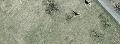
Closeup view
 

Attachments

  • Closeup pt 2.JPG
    Closeup pt 2.JPG
    27.5 KB · Views: 206
  • Closeup pt 1.JPG
    Closeup pt 1.JPG
    25.4 KB · Views: 199
Re: question on a topographic survey map.

after o got out of high school i worked for a land surveyor and we used those kind of maps to find the properties by using the deed.... all it had was the section township and range....then the exact distances and angles of the property......anyway to answer your question......yes that IS showing a house on theat property
 

Re: question on a topographic survey map.

It appears that maybe the former foundation and yard area of this place could have posibly been bulldozed and landscaped. Maybe there was no basement so the foundation was easily taken apart??

You may want to try to start right next to the road and swing a path parellel to the road, with the first swing right at the edge of the pavement. Remember, roads where a lot thinner in those days so the edge of the road now might have been part of the front yard then. Go for a long distance before and after where you think the house may have been, moving in four feet or so at a time. That way you can grid your finds and get a better idea of where the driveway was or other front yard activities. This cound help you visualize the property as it was. Keep good records if you swing.

Good luck

BDoo
 

Re: question on a topographic survey map.

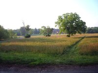
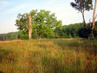
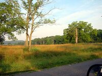
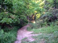
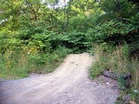
first off, Glenns5900...yep thats the place. I don't see anything even with the satellite photos you provided. I cannot use Google Earth on my pc cause it is to friggin old (work pc). Anyway here are some pics I took this morning from street level. The grass was wass too deep for me to wade in there and see anything. They don't get that far into the area with the tractor as you will see from the photos. I also took a pic of the area that shows on the topo map of the road that goes northwest from the circled area. (not at the end of the block make a left but kinda continue straight up the block) There is another house that shows on the map but this area is again covered with vegetation. There is an ATV path that leads pretty much where that road was. I took a short jaunt up that path and took some pics also. They are the dirt path in the photos (will mark the photo ATV path).

BDoo, I will try like you suggested by starting at the street parallel and working my way in form there. Might be a bit tough with all the high grass and weeds though. might give false signals from bumping won;t it?

Anyway take a look at the attached photos and any help you can give in where a house could have been would be appreciated. Using my photos, the survey map, and Glenns5900 oogle earthe photos maybe we can come up with something.

Thanks

Funkman
 

Attachments

  • trees_facing_SE.jpg
    trees_facing_SE.jpg
    37.9 KB · Views: 184
  • trees_facing_NW.jpg
    trees_facing_NW.jpg
    59.7 KB · Views: 179
  • trees_fromroad_facing_NW.jpg
    trees_fromroad_facing_NW.jpg
    56.6 KB · Views: 185
Re: question on a topographic survey map.

these are the atv path pics which I think is the blue circled road on the map.
 

Attachments

  • atv_path2.jpg
    atv_path2.jpg
    83.6 KB · Views: 198
  • atv_path1.jpg
    atv_path1.jpg
    77.7 KB · Views: 190
  • carmelitedrive.jpg
    carmelitedrive.jpg
    65.1 KB · Views: 186
Re: question on a topographic survey map.

I'm glad I could help with the satellite pictures. The last one I posted was too big to post so I took two smaller captures at the same magnification. You can always stitch them together.

Glenn
 

Re: question on a topographic survey map.

when land was cleared for farming they usually left a few large trees on the center or edges for shade for breaks and lunches. later when the fields are divided and roads are made they become nice places to build a farm house. this is a great site to investigate. please keep us all posted with results.
hh
al
 

Re: question on a topographic survey map.

will do Al. I would like to take a trek further up that ATV trail to see if I can find anything up there. The trail is all dirt so maybe some change fell out whiule they were riding.

Funkman
 

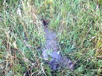
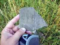
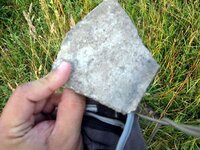
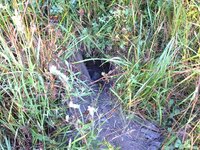
Went back to the site yesterday morning on my walk and went through the high grass looking for signs of foundation or something and came across a section of dirt that I think maybe a groundhog (which we have plenty of) was making his tunnel and helped me by throwing this stuff out of his tunnel. The patch of dirt is maybe 2 feet at most. In the photos you can see the hole and the discarded dirt and stuff. The pieces that are strewn through the dirt seem to be some kind of plaster like they used in the older houses I assume. Maybe someone can look at these photos and tell me.
Anyway, do these photos confirm that maybe a house did stand on the property or would it take a bit more investigating.

Thanks for looking.

Funkman
 

Attachments

  • IMG_0942.JPG
    IMG_0942.JPG
    75.5 KB · Views: 124
  • IMG_0944.JPG
    IMG_0944.JPG
    55.5 KB · Views: 135
  • IMG_0945.JPG
    IMG_0945.JPG
    49.3 KB · Views: 128
  • IMG_0946.JPG
    IMG_0946.JPG
    91.1 KB · Views: 126
it could be just a pile of trash that was dumped there years ago but it definitely man made, keep looking this site has real potential....al
 

will do Al,

The only thing that is blowing my mind is that hole. The dirt and plaster seem to have come out of that hole. Looking at the pics now I am not sure but the left side of the hole looks pretty straight, like it was a concrete block instead of just a normal rock...or I could just be seeing things. I think the next tim I get a chance I will not only investigate that hole, but also see if I can find any other piles of debris to determine if the foundation is still there in spots. Wish the grass was shorter though..had to wade through all that stuff to try and find the debris pile. Could not see it from road. Can only stumble blindly through the grass. I will do also as BDoo mentioned and start detecting at the roads edge since the grass is shorter there.

HAve another site to search for on the ATV trail that the same map shows another house up there. Will keep you posted on that one also.

Funkman
 

Top Member Reactions

Users who are viewing this thread

Back
Top