Prospectors Research Tools

Clay Diggins

Silver Member
Nov 14, 2010
4,958
14,504
The Great Southwest
Primary Interest:
Prospecting
Prospector's Research Tools

I haven't been around much this summer and with the desert prospecting season just starting it's a good time to show off what I did this long hot summer. I have been working with a few friends on a new non-profit organization to give you a single place for all your land research.

The result is MyLandMatters.Org. This is the gateway to your land information repository. Maps, books, tutorials, community resources and quality, easy-to-access information about the land around you.

No ads, No memberships, No log-in required. :thumbsup:

This past spring while sitting around with some friends we came to the conclusion that most of the important and useful things that we want to know about the land around us was difficult to locate and tough to understand. Despite the many sources of information there was no single place to find the information available.

We decided we could do something about that. We agreed to put our time and energy into creating a single place that anyone could find the answers to questions about the land.

It's a big project. It has taken a lot of work, learning and resources to get things started. But after six months of long days, and more than a few nights, the Land Matters repository is ready for you to use.

Land Matters is all about the land. You can find Land Status Maps, Active Mining Claims Maps (with live direct links into the current LR2000 claims database), A great collection of mining books, Land Laws, Geology books and maps, Forest Travel Plans and a whole lot more.

Land Matters is for land users. Our collections are guided by community input. That's you. Let us know what kind of material you would like to find in our Library or a particular map you would like to see. Help us build Land Matters to best serve the community.

We've already got a lot of things that prospectors have been asking for - the claims maps alone were almost universally requested. Land Matters isn't just for prospectors and miners. But you can help prioritize our efforts and drive the content of Land Matters. Prospectors now have a unique opportunity to help guide and build an information resource designed by prospectors and for prospectors.

We are just getting started filling the Library but there will be hundreds of books, maps and items added in the next few weeks. We've even got a Newsletter so you can get regular updates about new additions to the Land Matters repository.

Check it out and let me know what you think. Here are a few good places to start:

Tutorials - the current focus is on understanding Land Status.
Maps - We all like maps and we've got some you will love.
Library - search for something.

Heavy Pans
Barry & Leigh
 

Upvote 12
Well I looked into the Smith River/ Six Rivers land status today. Delnorter is substantially correct that most of the Smith River drainage is closed to mineral location entry.

The Smith River was one of the original Congressional Wild and Scenic Rivers in 1968. Most of the river has "recreational" designation with two small portions being in the "wild" class. Most of the "Six Rivers" forest designation was rolled into a National Recreation Area in 1990.

Those who are paying attention probably noticed I used the term "most" more than once. :laughing7:

There are several square miles of good gold land still open to location. I'm not about to start a land rush here but I will mention that those areas are very accessible. For the locals I will give a hint "golfing can be a rewarding sport". :thumbsup:

Another option is to investigate the thousands of acres of river fronted private land found throughout the Smith River drainage. Be nice to your neighbors and you might just get a great gold mining location.

We are working on some major upgrades to the Land Status Maps section of Land Matters that will allow the savvy researcher to discover these areas and many other for themselves.

Heavy Pans
 

Looks like I need to pick up another Hobby!:laughing7: Thanks once again Clay! You have given sight to this blind man...exciting stuff!

Jeff...If I can get the computer, my cell and you on the phone this pm, I'll call you @ home. I have the keys, now I need to learn how to drive these monster vehicles.

You BOTH have helped me so much...and just in time too because I have learned enough to apply it now at my location and where better ones could be.
 

Gold Mines and More!

Land Matters has added an Oregon Faults layer to the Oregon Geology Map.

The Oregon Geology Map is being sponsored by Brian Cole. Since Brian has generously sponsored the Oregon Geology map there is no donation request displayed before you can view the map. Every map that is sponsored can be linked to directly without a donation request. Please click on Brian's sponsorship banner at the top of the map.

By request we have added a United States Gold Mines Map. These are the locations and records of all the historical gold mines in the United States. Check out all the mines in the Eastern States! This is a very rich country. :laughing7:

Zoom in to see the gold mine names and click on any mine while in information mode and you will get a link to all the information about the mine! See what minerals were mined and when. Find out what type of rock and ores were found in the mine. Put on the PLSS layer or the aerial view and get even more information. There's a lot to look at there. :hello2:

I think the two Jeffs are going to like this new tool! Tell us what you think and what you would like to see next. :thumbsup:

Heavy Pans
 

I'm sure you can imagine how much this is helping us! I've got some leads. :thumbsup:

:tchest:
 

From the input I'm getting it looks like there are going to be a lot of folk doing some research this weekend. :thumbsup:

More to come!

Heavy Pans
 

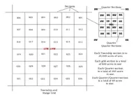
Funny you should mention the PLSS layers Clay! I just sent "The Other Jeff" a quick tutorial on how and why the PLSS is so important to us when it comes to filing a claim. I included the diagram below. I'm pretty sure I got the units right. I used that house I'm looking at buying to explain how the description of a claim has to be. ( You don't really think I'm going to give him an area I'm looking at for mining do ya?) I was basing the description requirements off those used here in Arizona and made sure to tell him to check on the California requirements for filing. Since they don't require a claim to be marked in California I figure there's most likely other differences as well.

I'm thinking of contacting the USGS and asking why the PLSS information is not on the newer PDF style maps. My older topos have the PLSS info on them but these new ones I've been downloading for Mohave County (103 maps so far) don't include the Township/range/section info on them and I for one am interested in knowing why this was omitted from the newer versions. They could at least include it as a layer in the PDF file that could be turned on and off as needed.

PLSS grid-1.jpg

Hope this helps anyone that's new to the Public Land Survey System (PLSS) understand more on how it works. Be sure to check on what the description requirements are for your state.
 

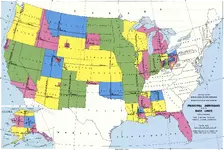
Just found this graphic that shows the different meridians and baselines used in the PLSS system and thought I'd share it here for those that are trying to understand how the system works. Notice that the entire United States has not been surveyed and that some states have multiple Meridians and baselines. Some states use the meridians and baselines that are actually located in other states.

Meridians-baselines.png

The graphic is a large file but offers a lot of good understanding of how this mapping system works. A google search for "Public Lands Survey System" will give you tons of information and graphics that you can use to really learn this system. What can I say? I'm an information junkie at times.
 

Meridians, Baselines, Townships and Ranges

Jeff you can find the Meridian and Baseline by turning on the PLSS layer after you load the map. All the Meridians are displayed with their names on that map layer.

There will never be a PLSS (Public Land Survey) done for the white areas on your map. I'll give a history lesson on that sometime but briefly the PLSS predates the Constitution but not the original 13 States. The PLSS was set up in the agreements found in the Northwest Ordinance. (There's a flashback to History class!)

Once you turn on the PLSS layer on your Arizona Claims Map you will see that the Gila and Salt River Meridian covers the whole State of Arizona. You can tell where you are on any given Meridian by the numbers and direction in the Township and Range.

For Arizona you will see that the Meridian and Baseline cross at the junction of the Gila and Salt Rivers just west of Phoenix. Go ahead and zoom in to that spot where the two lines cross with the "Aerial Photos" layer turned on. You will see that "Baseline" road runs along the baseline (east west line). It also explains why the Meridian (north south line) is named the "Gila and Salt River Baseline and Meridian". :laughing7:

That crossing place is the starting point for all measurement in the Meridian. Here is how you figure out where you are in relation to that starting point:

1. Any Township North of the Baseline will be labeled starting at 1N and going up in number as you move further North. Any Township South of the Meridian will be labeled starting at 1S and going up in number as you move further South.

1. Any Range East of the Meridian will be labeled starting at 1E and going up in number as you move further East. Any Range West of the Meridian will be labeled starting at 1W and going up in number as you move further West.

What we call a Township is really just an abbreviation for "Township and Range". The Township and Range numbers tell us where the Township is in relation to the center crossing point of Meridian. If the Township is labeled 12N 6W we know that we are 12 Townships north of the crossing point and 6 Townships west of that crossing point.

This is how the PLSS works on in all the different Meridians.

That should give an information junkie something to ponder. :thumbsup:

Heavy Pans
 

Last edited:
HUH???? :icon_scratch:

I didn't realize that the PLSS system went THAT far back! Almost as far back as certain members here. (You know who you are!!!)

It also explains why Texas is blank. (Or is that just certain miners you send to me and Chris? :tongue3: I still chuckle when I think about those guys! )

I keep telling you that I'm blind in one eye and can't see out of the other Clay! I never noticed the Meridian listed on the pop up information window. Just the Township/Range. I'll look again.

Still, learning the PLSS system, it's extents and limitations etc has been fun for me. Making sure that a certain grasshopper understand it as well has become a mission of sorts for me. At least if he gets to the point he understands it we can "talk" in PLSS and be on the same grid section. Much easier than having to download all the California topos! I've only gotten about 2/3 of Mohave County so far and that's over 100 maps!!!! I shudder at how many maps it would take to cover the gold areas of Calif.!
 

Jeff...this has been like learning a second language to me and frankly, I'm getting sick of the "Memory Full' error message I keep getting in my head. But I will learn it, just gonna take a little longer than anticipated...like everything else. :merror:
 

<=====<<< is sending the Grasshopper a memory upgrade.

P.S. I've also worked you up another "training aide" that I'll email ya later. How I combine the info from the Map. PLSS layer, Activity layer and the Land management layers to locate areas to go check out. Eventually I'll work up a spread sheet/data base with the same info on a much larger scale.
 

Last edited:
Well I looked into the Smith River/ Six Rivers land status today. Delnorter is substantially correct that most of the Smith River drainage is closed to mineral location entry.

The Smith River was one of the original Congressional Wild and Scenic Rivers in 1968. Most of the river has "recreational" designation with two small portions being in the "wild" class. Most of the "Six Rivers" forest designation was rolled into a National Recreation Area in 1990.

Those who are paying attention probably noticed I used the term "most" more than once. :laughing7:

There are several square miles of good gold land still open to location. I'm not about to start a land rush here but I will mention that those areas are very accessible. For the locals I will give a hint "golfing can be a rewarding sport". :thumbsup:

Another option is to investigate the thousands of acres of river fronted private land found throughout the Smith River drainage. Be nice to your neighbors and you might just get a great gold mining location.

We are working on some major upgrades to the Land Status Maps section of Land Matters that will allow the savvy researcher to discover these areas and many other for themselves.

Heavy Pans

Great info !! Some of the tributaries of the Smith are excellent for a small Bazooka!....I mean pan only...:laughing7: The headwaters of the North fork are in Oregon.
I grew up in that area, and I remember people dredging the Smith.
 

how do I tell if a claim wasn't renewed or the paperwork was not filed correctly?
Will it say Case deposition Closed?
For instance I am looking at a report from the iServer on a claim and noticed this information at the bottom:

04/04 location date
04/08 recordation notice rec
04/08 Location Year / maint 2014; $140.00
08/06 decision/notice issued: Failure to amend
06/02 undeliverable address: DudesName
05/01 Decision Notice issued: Defective Col
04/08 map in lead file: gibberish (sure it means something lol)
04/08 acct adv in lead file: gibberish
04/22 county recordation: gibberish

What do I make of that? What I'm really looking for is how to find out if a claim is open before I get the GPS out and go get in the truck and drive all over the dang country looking for an open claim.
Any help is naturally appreciated, this tool ROCKS! (pun is indeed intended in this instance. Well done!)
 

Last edited:
how do I tell if a claim wasn't renewed or the paperwork was not filed correctly?
Will it say Case deposition Closed?

I've got a much more detailed explanation on how to get the most out of these reports in the works Prospector70 but the brief answer is yes the Case Disposition tells you the current BLM case status on any single claim.

That Case Disposition does not tell you that the land is open to claim. Life is rarely that simple in the world of claim locations. The fact that one claim is CLOSED does not mean there isn't another claim there that was located before or after the CLOSED claim. The BLM could care less about overclaims or actual claim location.

The BLM LR2000 is just one step in the process. The link to the claims report on the Land Matters Claim Maps is just a tool - it's not the final answer.

The process we use professionally to determine lands open to claim is to:

1. Determine what the Legal Land Description (LLD) is. The LLD consists of the Meridian, Township, Range, Section, Quarter Section and aliquot part of the location. You can determine that description from the Public Land Survey System (PLSS). The PLSS is the Legal Land Description by which mining claims are made by. That's the law and has been since 1789 - no matter what parcel# the tax assessors office call it. You can determine the PLSS of your location by using the Land Status Map and turning on the PLSS layer and zooming in to your area of interest.

2. Take that LLD and look up the land status on the Master Title Plat map for the Township your claim is in. You should also download the supplements and the Historical Index and cross refrence with the Land Orders listed for that area. This will tell you if the land is claimable or closed to claims. All restrictions will be noted on the Master Title Plat and it's supplements. You can download a free copy of that Master Title Plat, supplements and Historical Index at the Government Land Office website.

If the land you are interested comes up as locatable on the Master Title Plat go to number 3 below. If not you will not be able to make the claim. Just because somebody claimed land before doesn't mean it was claimable. The BLM is well known for accepting claim files and money on claims they will eventually challenge and close.

3. Look up the LLD on the BLM LR2000 database website. Be sure to include adjacent sections. Often the BLM will choose to put cross sectional claims in their smallest fraction. This will tell you the current file status for all the claims in the LLD. If a new claim is filed with the BLM it could take anywhere from a week to more than a year before it will show up there. Even so it's a free stop and the information you get on the area claims will help you at the next step.

Just because the BLM shows or doesn't show an open (or closed) claim where you are looking you still don't know the whole story until you do the next three steps.

4. Check for Mining Claim Location Notices for that LLD at the County Recorders office. If you got a list of the closed claims, with their location date, you can eliminate those claims from your final list - much cheaper.

Most Counties have an online search feature so you can look that up yourself at home. Find the Mining Location Notices, Location Amendments and annual filings for the closed claim and all the claims nearby. You will need the grantors names and the Book and Page each is recorded on.

Mining Claim Location Notice and Legal Land Description are how County Recorder's deal with Mining Claims. They don't keep a map of claims. They do not do searches for location notices without knowing the Grantor name, or the Grantee, or the LLD or the Book and Page. Most Counties charge for record searches that don't have at least two of the above classifications. The County Recorder can help you a lot, treat them well and it can be easy.

Once you have a list of the Book and Page Numbers for the above recordings contact the County Recorder (mail, phone, email, walk in doesn't matter) and order copies of all the pages of each Recording on your list. There will be a charge for this but by having the Names and Book and Page Numbers you only have to pay for the copies - not thousands of dollars in research fees. You do not need the copies certified.

5. Take the information from the claims records you got that are currently active and draw out each claim on a topo map. There should be a map with each claim location notice. Once you have all the active claims on the map look and see if the area you are interested in is still open (no other claims there). Don't try to "fix" the claim locations if they overlap - that happens and it's one of the things you are looking for on your map. It's entirely possible the claim that was dropped there was an overclaim and there really isn't anything open.

6. If everything looks clear once you've done the above steps it's time to put the boots on the ground. Take your map with you and look around the claim area and see if there are any recent monuments or stakes. LOOK for a new claim there. If there is none you can then prospect and see if the land is mineral in character. If it's all good go ahead and put up a monument stake with your location notice and map and mark the claim boundaries.

How you stake and how you describe the claim (aliquot part or metes and bounds) will be determined by what you learned about the area of land you are claiming. In most cases a simple LLD is all you will need as a description. Sometimes you will need to use metes and bounds (distance and direction). You won't know that until you have made your map and checked the location on the ground.

Then you can proceed to record your location at the county and make your FLPMA informational filing with the State BLM office.

At that point you might have a valid claim. Everyone who locates a claim has 30 - 90 days (depending on the State) to make a public Mining Claim Location Notice at the County Recorder and 90 days to give an informational notice, pay fees and obtain a claim number from the BLM. In other words somebody else might already have made a claim there before you but they just haven't made their recording/filing yet. It's all about who puts up the first monument, not when you record or file the location.

Doing these things out of order can waste a lot of time and when it comes to staking, recording or filing your claims it could invalidate them.

Heavy Pans
 

Yay! Thanks sir! :)
 

I also noticed a new Minerals layer on the Arizona map today. I haven't taken time to check it out yet as I was looking up other information to go into my field notebook.

I also talked to one of the on-line reps from the USGS today and though she was very nice, she couldn't explain to me why the PLSS data isn't included in the newer maps. The PLSS data is still on the older versions. She also directed me to the GeoCommunicator site but like everything else that has to do with the BLM, it's about as clear as mud. I found data sets for the area I've been researching but I don't know if it's stand alone or if some viewer is required to be able to see the file. Their download info is also very lacking. No mention of file size, or even what type of file it is. .Doc .PDF etc.

I also looked into those "ToughBooks" Clay. They've got a large selection of them with different bells and whistles. Wide range of prices as well. Almost had a heart attack when I saw the prices on the higher end units! Well beyond what I'm wiling to pay for a computer that will be used in the field! Maybe a cheaper laptop with a good Pelican or Anvil case.
 

Top Member Reactions

Users who are viewing this thread

Back
Top