Prospectors Research Tools

Clay Diggins

Silver Member
Nov 14, 2010
4,958
14,509
The Great Southwest
Primary Interest:
Prospecting
Prospector's Research Tools

I haven't been around much this summer and with the desert prospecting season just starting it's a good time to show off what I did this long hot summer. I have been working with a few friends on a new non-profit organization to give you a single place for all your land research.

The result is MyLandMatters.Org. This is the gateway to your land information repository. Maps, books, tutorials, community resources and quality, easy-to-access information about the land around you.

No ads, No memberships, No log-in required. :thumbsup:

This past spring while sitting around with some friends we came to the conclusion that most of the important and useful things that we want to know about the land around us was difficult to locate and tough to understand. Despite the many sources of information there was no single place to find the information available.

We decided we could do something about that. We agreed to put our time and energy into creating a single place that anyone could find the answers to questions about the land.

It's a big project. It has taken a lot of work, learning and resources to get things started. But after six months of long days, and more than a few nights, the Land Matters repository is ready for you to use.

Land Matters is all about the land. You can find Land Status Maps, Active Mining Claims Maps (with live direct links into the current LR2000 claims database), A great collection of mining books, Land Laws, Geology books and maps, Forest Travel Plans and a whole lot more.

Land Matters is for land users. Our collections are guided by community input. That's you. Let us know what kind of material you would like to find in our Library or a particular map you would like to see. Help us build Land Matters to best serve the community.

We've already got a lot of things that prospectors have been asking for - the claims maps alone were almost universally requested. Land Matters isn't just for prospectors and miners. But you can help prioritize our efforts and drive the content of Land Matters. Prospectors now have a unique opportunity to help guide and build an information resource designed by prospectors and for prospectors.

We are just getting started filling the Library but there will be hundreds of books, maps and items added in the next few weeks. We've even got a Newsletter so you can get regular updates about new additions to the Land Matters repository.

Check it out and let me know what you think. Here are a few good places to start:

Tutorials - the current focus is on understanding Land Status.
Maps - We all like maps and we've got some you will love.
Library - search for something.

Heavy Pans
Barry & Leigh
 

Upvote 12
Turn on the Topo base layer on the Land Matters Maps. It's all there with better detail the more you zoom in. :thumbsup:

Heavy Pans

It seems as though I may be doing something wrong. I'm in a window with a map of the U.S. and I've selected the "Topo" box in the menu; however, any time I try to move the position of the map, or zoom in or out, there is a long delay while it says "Creating Map" and then when it finally gets done, it's zoomed in too much, or on a place I wasn't selecting. This seems like a great resource, but it may be a little more complicated than I'm looking to get into. Is there somewhere online with a high resolution topographic map that has simple functionality for features such as panning and zooming similar to Google Earth?
 

It seems as though I may be doing something wrong. I'm in a window with a map of the U.S. and I've selected the "Topo" box in the menu; however, any time I try to move the position of the map, or zoom in or out, there is a long delay while it says "Creating Map" and then when it finally gets done, it's zoomed in too much, or on a place I wasn't selecting. This seems like a great resource, but it may be a little more complicated than I'm looking to get into. Is there somewhere online with a high resolution topographic map that has simple functionality for features such as panning and zooming similar to Google Earth?

All of the map sites below are fast and easy to use!

I like to get topo's from:. Viewer | topoView

Very easy to use, fast and can be viewed in Google Earth!

GeoPDF format is easy to download and save!

GeoTIFF – The GeoTIFF files are a compressed, 300 dpi TIFF image format, with embedded georeferencing information so that the map can be used directly in a Geographic Information System (GIS). The GeoTIFFs are generated at true scale, allowing users to plot the map at the intended map scale in cases where a hard copy is needed.

JPEG – The high-resolution JPEGs, or 'Browse JPEG' format are useful for getting a quick view of the map in order to find place names or simply explore the map area without the need for downloading a large file.

KMZ – The KMZ format is a compressed form of the KML format which is used for displaying the maps in Google Earth.

This is also a great map viewer with lots of options, fast and easy to use!

TNM Download

Last but not least:

The USGS Store - One stop shop for all your maps, world, United States, state, wall decor, historic, planetary, topographic, trail, hiking, foreign, satellite, digital
 

Last edited:
It seems as though I may be doing something wrong. I'm in a window with a map of the U.S. and I've selected the "Topo" box in the menu; however, any time I try to move the position of the map, or zoom in or out, there is a long delay while it says "Creating Map" and then when it finally gets done, it's zoomed in too much, or on a place I wasn't selecting. This seems like a great resource, but it may be a little more complicated than I'm looking to get into. Is there somewhere online with a high resolution topographic map that has simple functionality for features such as panning and zooming similar to Google Earth?

It sounds like you are trying to use the map like it's a google map. The Land Matters maps have more and faster functions than other web maps and they can be confusing if you try to use them like other web maps. On a google or other simple map you zoom in by clicking ... and clicking ...and clicking. Anywhere from 19 to 21 times you need to click to zoom in all the way. :BangHead:

On a land Matters Map you can zoom in to your area of interest in one shot. Just draw a box around your area of interest by holding down your mouse button and dragging the cursor at an angle. Release the mouse button and the map zooms to the area you drew the box around. One zoom instead of click ..click ...click ...etc.

To pan a Land Matters Map you will need to select the PAN tool from the menu on the right. That's the one with the four arrows Screen shot 2016-05-10 at 7.48.34 AM.png. Once you have clicked on the PAN tool you can pan the map by clicking and dragging.

Unlike simple web maps Land Matters Maps remember every click you make. If you click on the map while it's still drawing or if you click more than once the map will see those clicks as commands it need to execute as soon as the current map is drawn. That can lead to confusing jumping around or zooming in or out if you don't know why it's happening.

Slow maps are due to several things all of which you can control. The first thing to do if your connection can't handle the bigger maps loads is to make your browser window smaller. A window half the size will load 4 times faster. A big speed up is to turn off all the base maps until you have zoomed to the general area you want to study. Without the base maps on you will find maps will load in a few seconds. After you have zoomed in to your area of interest turn on the base layer you want to see.

Land Matters Maps are custom made to your specifications which each click on the map. The server we create them on is very fast. On our server maps take less than 2 seconds to be created but if you've ordered a large complex map the image created will be on the order of 3 Megabytes. That's going to take a while to transfer across your internet connection, how long depends on your internet connection. Slow connection and big map = slow load.

There are a lot of advanced features on Land Matters Maps you won't find on other web maps. These maps are designed for advanced research. There are huge databases chock full of information that can be accessed with the search tools. If you just want to look at a one or two layer visual map you might want to try one of the small leaflet or google maps etc. The topo layers there may be difficult to find, less detailed and just as slow to load to a big window. For the topo map Land Matters is using all maps that try to display it will be slow - it's a detailed map coming from a slow government server.

Try looking around the information found in the HELP button at the top right of your Land Matters Map window. With a few clicks there you will find instructions and tips on how to tap into the power of these research maps. With a little practice using the different tools on a Land Matters Maps I think you will find the information you are looking for and a lot more. :thumbsup:

Heavy Pans
 

I like your site Clay, very Helpfull to us miners, hope one day i can afford to donate, till then i keep my visits short.
Thanks good job............

GT...........
 

Just to clarify...I certainly didn't mean to imply that my failures with the Land Matters site were anything other than "user error." Once I have some time to poke around and get a lay of the land I'm sure I'll get the hang of that system. Based on your description, it strikes me as similar to the differences between iPhone and Android - one may be a bit more simple and intuitive for basic functions, while the other is capable of a lot more if you take the time to learn.

In this case, I am reading a book about a lost Spanish lost gold mine (I'm just POSITIVE I'll find it AND get rich enough to retire) in an area with which I am fairly familiar. However, the book makes reference and assigns names to several streams and other features not named on the Forest Service maps I have. The links provided by 'chlsbrns' - thank you! - got me most of the information for which I was looking. I will definitely take the time to check out the awesome features of the Land Matters maps on my next guaranteed billion-dollar lost mine search!

Glad you got what you were looking for HHM. :thumbsup:

If it's old Topo maps you are looking for Land Matters has more than a quarter million available by simply clicking on map. You can get all the years (back to 1841) and resolutions available as well as Forest Service and Historical Shoreline Survey Topos all on one Map the Topo Map Downloads.

Heavy Pans
 

I like your site Clay, very Helpfull to us miners, hope one day i can afford to donate, till then i keep my visits short.
Thanks good job............

GT...........

Thanks gold tramp I hope it helps you. Visit as often and as long as you need. It's a tool - if you don't use it it'll get rusty. :thumbsup:

Heavy Pans
 

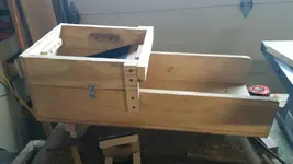
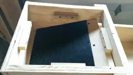
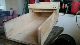
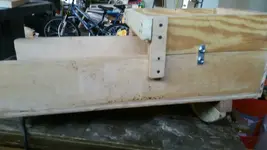
Building forst rocker box what do you think
 

Attachments

  • 1463097639081.jpg
    1463097639081.jpg
    49.3 KB · Views: 118
  • 1463097657699.jpg
    1463097657699.jpg
    55.4 KB · Views: 118
  • 1463097700855.jpg
    1463097700855.jpg
    53.1 KB · Views: 121
  • 1463097731125.jpg
    1463097731125.jpg
    49.3 KB · Views: 120
Mining Clams Maps updated to May 15, 2016

I'm guessing many of you already noticed (2200 claims maps per hour). :headbang: For those of you who didn't:

Land Matters has updated the Mining Claims Maps to May 15th. :thumbsup:

Lot's of changes this cycle.

California is starting to get some movement on updating the claims files this month - lots of land opening up the last month. Oregon has closed a bunch of claims in the last few weeks. For those who think nothing ever changes in South Dakota this might be your lucky week!

Heavy Pans
 

used your site last night thanks again.
we must be on the prowl again ?
 

Mining Clams Maps updated to June 1, 2016

You are welcome gold tramp. Always prowling. :laughing7:

The Land Matters Mining Claims Maps have been updated to June 1, 2016. :thumbsup:

Finished the uploads late last night after a long day. The BLM was running a little slow this time.

As usual with a holiday the BLM database updates slowed down this on this twice monthly report. The big surprise this time was South Dakota with 209 closed claims. Some good ground looks to be opening up in the Spearfish area. :hello2:

Heavy Pans
 

Heading to the county recorder tomorrow. Thanks Clay for the update!
 

It's that time again! Mining Claims Maps Updated.

From the thousands of maps being made I'm guessing that most of you already know that the Land Matters Mining Claims Maps have been updated again.

Current as of today June 15th. :thumbsup:

Big changes this half month are in South Dakota and Wyoming. A total of 2,141 claims closed in the last 15 days. California is slowly catching up with 129 claims closed. Wyoming closed more than 300 placers this period, many of them located in the 60's and 70's.

Check out your favorite area- you might be surprised what's open for prospecting this season. 8-)

Heavy Pans
 

There was a lot of claims closed this last year. I was theorizing the struggles of big gold and the current high cost ratio to mine caused a huge downswing in exploration. Experts say the lack of oil exploration going on right now due to the glut of supply now will create a huge spike in the price in 2018-2019. I think the same may hold true for gold as so few companies are actually making money and most companies can't get the financing to bring projects online or continue exploration.
 

Claim Maps Update

Hope everybody is having a good weekend. :hello:

Land Matters Mining Claims Maps have been updated to July 1.

A lot of placer claims opened up in California the past two weeks. 8-)

Maybe this will help some of you who haven't headed out yet. :thumbsup:

Heavy Pans
 

Not sure why this thread jumped over here? Seems off topic and confrontational. Certainly has nothing to do with prospector's research tools.

I can understand a non-prospector laughing in prospector's faces. Happens all the time. Just keep in mind that that computer/phone you are posting from has some gold from the Carlin Trend in Nevada where virtually all the gold is micron sized or less. Some of the big mines in Nevada use a lot of sodium citrate (found in strawberry jam) in their gold processing.

Go back to the thread this was taken from and see how funny science can be. Chemistry is your friend. :thumbsup:

Heavy Pans

Clay what did comment have to do with original thread it was posted in? If it was valid comment in original thread why complain about it in this thread even though it is off topic to this thread..

Chlsbrns stop insulting Clay's site..

Chlsbrns, consider Jeffs warning times 2..... There will be NO More warnings, you have reached your limit, if you find you can't log in you will know why...
 

Last edited:
It's that time again! Mining Claims Maps Updated

As they are twice each month the Land Matters Mining Claims Maps have been updated.

The maps and claims information is current to July 15th, 2016.

For those living or mining in Colorado now would be a good time to look closely at one of the famous historic mining districts. 8-)

Good stuff available to the astute researcher! :thumbsup:

Heavy Pans

Clay, I cant say how happy I am with mylandmatters, on the first noticed some land opened up in Colorado, 2 weeks later i see my claim on there :D. Awesome research tool!!!
 

Top Member Reactions

Users who are viewing this thread

Back
Top