Prospectors Research Tools

Clay Diggins

Silver Member
Nov 14, 2010
4,958
14,509
The Great Southwest
Primary Interest:
Prospecting
Prospector's Research Tools

I haven't been around much this summer and with the desert prospecting season just starting it's a good time to show off what I did this long hot summer. I have been working with a few friends on a new non-profit organization to give you a single place for all your land research.

The result is MyLandMatters.Org. This is the gateway to your land information repository. Maps, books, tutorials, community resources and quality, easy-to-access information about the land around you.

No ads, No memberships, No log-in required. :thumbsup:

This past spring while sitting around with some friends we came to the conclusion that most of the important and useful things that we want to know about the land around us was difficult to locate and tough to understand. Despite the many sources of information there was no single place to find the information available.

We decided we could do something about that. We agreed to put our time and energy into creating a single place that anyone could find the answers to questions about the land.

It's a big project. It has taken a lot of work, learning and resources to get things started. But after six months of long days, and more than a few nights, the Land Matters repository is ready for you to use.

Land Matters is all about the land. You can find Land Status Maps, Active Mining Claims Maps (with live direct links into the current LR2000 claims database), A great collection of mining books, Land Laws, Geology books and maps, Forest Travel Plans and a whole lot more.

Land Matters is for land users. Our collections are guided by community input. That's you. Let us know what kind of material you would like to find in our Library or a particular map you would like to see. Help us build Land Matters to best serve the community.

We've already got a lot of things that prospectors have been asking for - the claims maps alone were almost universally requested. Land Matters isn't just for prospectors and miners. But you can help prioritize our efforts and drive the content of Land Matters. Prospectors now have a unique opportunity to help guide and build an information resource designed by prospectors and for prospectors.

We are just getting started filling the Library but there will be hundreds of books, maps and items added in the next few weeks. We've even got a Newsletter so you can get regular updates about new additions to the Land Matters repository.

Check it out and let me know what you think. Here are a few good places to start:

Tutorials - the current focus is on understanding Land Status.
Maps - We all like maps and we've got some you will love.
Library - search for something.

Heavy Pans
Barry & Leigh
 

Upvote 12
More newer Geology maps!

Bejay wanted Structural Geology and the previous older Geologic Folios have been very popular so we came up with another group of Geology maps for download.

We've added direct access to all 1,784 of the USGS Geologic Quads to the Land Matters Geology Library.

You can search for those Geologic Quads by quadrangle name or get the whole list to browse through by typing "gQuad" in the search box or by searching for "Geologic Quadrangle" with the state name.

These are higher resolution and more recent geology maps than the previous folios. There are 10 in Oregon for Bejay and all the other Oregonians as well as many more in the United States with as many as 700 in one state. :laughing7:

We've got lots more geology resources coming to the Library soon as well as a few surprise maps. :thumbsup:

Heavy Pans
 

Thanks Clay for the update. The amount of information is HUGE ::thumbsup: The need to have even a larger web provider/server that can handle the HUGE material load is eminent. All those who have made donations and continue to do so are greatly appreciated. Clay will be the first to acknowledge that the amount of new material; that can be added, is beyond imagination. Land matters can provide information for a vast array of users. Anything to do with, or on, the land beneath our feet is such information. Barry and his wife are providing endless data/info. A lot of work and effort.

Thanks for all the support. I know I am going to enjoy the ability to see the structural geology maps....as they hold the key to future discoveries and potential mineral claims....(along with the topo maps and ownership). I only wish I were still a young spring chicken and could prospect; dawn to dusk, up and down the steep Oregon landscape. Give me my shrimp gun, meat lug, rock hammer, gold pan and some crevice tools and who knows what lay out and about. Why would one buy a claim when there is so much info available to make new discoveries.

Thanks again Clay, and give my best to "L".

Bejay
 

Better Base Maps!

We've upgraded several of the Land Matters Base Layer maps big time.

You will find these Base Layers on every Land Matters interactive map. They form the bottom of the maps layer stack and provide a visual reference for the other map layers.

We've made the Aerial Photos ("Satellite images"), Topo and Street maps load about 4 times faster and increased their color quality. For those of you on faster connections you will see a big difference in load times and quality.

We've increased the ground resolution of most of the Aerial Photos by more than 3 times. Ground resolution is a whopping 1 foot in most of the United States now! :thumbsup:

_____________________

We've also upgraded the Real Time Weather Map. This map now has higher resolution real time radar that will let you see the progress of storms anywhere in the United States as they happen. The real time infrared satellite updates show cloud masses and their movements right along with the radar day or night.

Just click on the "Refresh Map" button to watch the radar and cloud imaging change as the weather changes. You can zoom in and out and move the map just like any other Land Matters map but the map shows current weather conditions.

These weather maps are one of my favorites when I'm planning an outing. Get the real thing at home when you need it.

More coming soon!

Heavy Pans
 

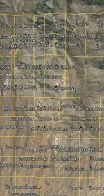
google earth has the miners cache thats gives exact boundries of mining claims. i dont know how they are able to do this (35$ yr subscription) but if you were able to apply that information to your website it would be HUGE. im chippin in what i can and we here at the forum should publicize the site at the face book page of our local miners associations. i think that will help with the funding
 

google earth has the miners cache thats gives exact boundries of mining claims. i dont know how they are able to do this (35$ yr subscription) but if you were able to apply that information to your website it would be HUGE. im chippin in what i can and we here at the forum should publicize the site at the face book page of our local miners associations. i think that will help with the funding


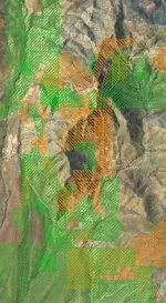
MineCache does not show actual or accurate claims boundaries. There is nothing close to exact about the MineCache Google Earth overlay. No program that uses the BLM LR2000 database (including MineCache) can show boundaries with any better than 1/2 mile accuracy.

I map the actual boundaries of thousands of claims a year so I can show you a comparison of the actual claims boundaries.

The exact same area of Rich Hill, on the same day, is shown in these two examples:

MineCache Claims
RHC.jpg

Actual Claims boundaries (orange for Lode and green for Placer)
RHF.jpg

Big difference huh? :laughing7:

Now that is cleared up you can go see the mining claims mapped to BLM LR2000 standards for free on Land Matters Mining Claims Maps.

We update Land Matters claims maps about once a month. Mine Cache updates their several times a year. Whoever updated last is the most current information.

Land Matters updated their claims on January 16, 2015. You can see what the last update was on all the claims maps results returns. I'm not sure how you check on the last update to Mine Cache as I haven't paid the $35.

Educate yourself and prosper! :thumbsup:

Heavy Pans
 

Last edited:
Accuracy during your due diligence stage is VERY important beekbuster. If your data is off you stand a chance of loosing your claim because your either filed over another claim in part or in whole or made some mistake in the actual location. Nothing is worse than spending a lot of time to locate a claim and then loose it because you messed something up in your due diligence research. To add insult to injury, the county and the BLM is not going to refund your fees because you made a mistake. They expect you to have your chit together and know the requirements for filing before you go see them.

Map reading is one of the most important skills that a prospector can develop. They do not allow GPS cords to be used when filing (yet) so being able to read a map and find areas on the actual ground using them is a must. If you don't know how to use a map in the proper way, then again you run a chance of miscalculating the boundaries of a claim. The land matters site has a copy of the Army training manual for map reading and land navigation. This is THE BOOK on map reading and has taught more of us Army Dogs how to get from point "A" to point "B" accurately than you can shake a .50 Cal round at.
 

One more caution: sometimes the available data is just wrong!
Example: last summer I was researching an area a friend wanted to prospect. I found a couple of areas of National Forest land according to the county Assessor's GIS website (shows all parcels in the county). I confirmed on LR2000 and with the county that there were no active claims in this general area. On one of the parcels we were confronted by a local who said we were on private property and needed to move a ways up stream. Rather than show her the map I'd printed from the county web site, I just agreed to move. Later I contacted the county about the conflict of understanding. They initially denied there was a problem. After several months they sent me another email saying they had found a flaw in the original survey data (which had been digitized by the BLM years ago) and over 90 parcels of land had to be corrected in their system with borders moving well over 100 feet in each case. Oops right?!

Keeping this in mind, I will continue to be very respectful of locals in the areas I visit to prospect and it's another reason to make friends with your neighbors like GoldenIrishman says to do when you file a mining claim.
 

And then there are the land owners who have had their land passed down through the generations and lost track of their boundaries. I had a guy come up and accuse me of mining on his property and he told me that he owned everything down to the end of my claim. I do mine on his property also because I've known his dad forever and have permission but because I know the area, I was able to explain and show him where his corner markers are. I've had them marked with yellow marking ribbon for quite a few years. So just because someone tells you that you are on his property, have the knowledge and know exactly where you are and also be able to help him know his boundaries. I made a new friend that day.
Years ago we had a home owners association come down and tell us that we couldn't shoot on our land at out shooting range because it was against their code. We told them they were trespassing and to go home... lol, and then they came back with the Sheriff. Because they were now trespassing in the middle of a 160 acre homestead that had been there since before their houses ever existed, the Sheriff told them that they had no say here and to leave peacefully while he stayed with us and we all did some more shooting. The funny thing abut this was that they are close to a mile away from us and thought that their new association now had control over everyone in the area, not just in their little housing project.
 

Recently I met with a fellow miner and we got on the Land Matters mapping pages and got into the ownership mapping section. Being able to pan around on the map we were checking out & looking for locations in known mineral areas that were either USFS or BLM. Much of the lands are actually checker boarded with private ownership surrounding public land spots. Some are small and yet some are larger. Low and behold we found some public lands that had small portions lying in prime placer locations. The small cites we located were surrounded by "private ownership lands". Yet they had roads adjacent to them that were funded using the publics money (hint!)....USFS and/or BLM

Hello secluded place to prospect and possibly make discovery. Thanks "Land Matters" for the great mapping venues!

Bejay
 

Thank you for all your work on this project .
I haven't seen it yet but you and every one In valved are very appreciated . Some times it's over whelming on the internet .
 

I'm probably doing something wrong, but when I use the landmatters site in ca I cannot figure out how to look at claim boundaries. It does show the section that is claimed but not the boundaries. Am I doing something wrong or is that just how it works? I have many custom overlays I've been using for years with Google earth, took me a long time to figure out how but this site is great as it's pretty much the same and better in many ways.
 

As of right now you won't see the claim boundaries on LandMatters. I believe it draws its information from the LR2000 which only reports location down to the quarter section. Needless to say that's not enough to be able to plot the locations accurately. You will still need to go to the Registrars office for the county in which the claim is in to get an accurate description of the claim boundaries. It's a good idea to double check any listed boundaries anyway.
 

MineCache does not show actual or accurate claims boundaries. There is nothing close to exact about the MineCache Google Earth overlay. No program that uses the BLM LR2000 database (including MineCache) can show boundaries with any better than 1/2 mile accuracy.

I map the actual boundaries of thousands of claims a year so I can show you a comparison of the actual claims boundaries.

The exact same area of Rich Hill, on the same day, is shown in these two examples:

MineCache Claims
View attachment 1117440

Actual Claims boundaries (orange for Lode and green for Placer)
View attachment 1117442

Big difference huh? :laughing7:

Now that is cleared up you can go see the mining claims mapped to BLM LR2000 standards for free on Land Matters Mining Claims Maps.

We update Land Matters claims maps about once a month. Mine Cache updates their several times a year. Whoever updated last is the most current information.

Land Matters updated their claims on January 16, 2015. You can see what the last update was on all the claims maps results returns. I'm not sure how you check on the last update to Mine Cache as I haven't paid the $35.

Educate yourself and prosper! :thumbsup:

Heavy Pans

Sorry lol... yesterday I clicked on this thread as I haven't looked at it in a while and this was the current post, honestly I read it wrong and seeing the photo with the claims boundaries I was thinking that Clay was referring to a function of the landmatters site. Sorry about the confusion :P
 

its not I think Clay and co. maybe the only ones putting claims boundaries on maps and they are not doing for us.....not that he wouldn't if he had the time
Nothing provided from BLM shows actual boundaries.
 

Some good first hand information from everyone. Real life experiences shared by miners go a long way in helping us understand the actual process and problems you will need to solve to navigate your way to open prospecting ground. Thanks for the feedback! :thumbsup:

It's better we understand the quality of the information we encounter in our research. Presuming that any map or internet resource will tell you about current conditions on the ground can be misleading.

In my work for mining companies I am often required to do intensive research on land status including mining claims. Resources like MineCache or Land Matters are just the beginning of a much longer process to determine land status. They are useful tools but they don't have the final answer for anyone trying to determine if they can prospect or claim an area.

At Land Matters the claims could be shown to the nearest quarter section but we made the decision not to take it to that level. That may sound as if we are trying to restrict the information available but actually we are just trying to give you the most reliable information.

The BLM could care less where a claim is. The only requirement for their Mining Claim Case File is that you describe the claim to the nearest quarter section. A quarter section is 1/2 mile square. Even knowing the quarter section the BLM lists the claim as being in doesn't narrow your search to just that half mile.

In my earlier post I showed the actual mining claims on Rich Hill at a certain point in time. You probably noticed the actual claims boundaries look more like a jigsaw puzzle rather than the orderly grouping of rectangles in the MineCache example. The simple fact is that mining claims are made for valuable minerals - not to fit an orderly grid. This leads to some serious problems when you are trying to fit those disorderly mining claims into orderly quarter sections.

__________________________________________

Here are a few real life examples.

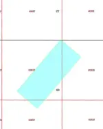
This is an active lode claim made in 2005. Notice that the direction of the discovery was not north/south and it doesn't fit into any sort of grid. In fact most of the claim is in Section 20 with just a few feet in Section 17.

IF you were to map the claim to the first quarter section listed in the BLM's case file you would put the claim in Section 17 but in reality there are only a few square feet in that Section. The bulk of the claim is in Section 20.

Typically - but not always the BLM will list the lowest numbered section first in their description. So what we end up with is a claim put into the grid for Section 17 even though the claim is actually in Section 20.

If you include the WHOLE BLM LR2000 quarter section description the claim ends up in the SW and SE quarters of Section 17 and the NW and NE quarters of Section 20. That is 640 acres - 1 square mile. Now you are looking around a square mile for a claim that is 20.66 acres. THAT is the accuracy of the BLM LR2000 in real life.

Claimqq.jpg

__________________________________________

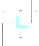
The next example involves an recently active placer claim made in 1974. As you can see this claim covers portions of three sections and crosses two townships.

The BLM has this claim listed as 10N 1E Section 35 SE quarter section and 11N 1E Section 2 NE quarter section.

The location record for this claim clearly states that the claim is also located in 11N 1E Section 1 NW quarter section. The BLM didn't bother adding that into their Mining Claim Case File. :BangHead:

So we have another claim that is located by the BLM to a 320 acre area and ignores one of the three sections the claim is actually located in. In the BLM the accuracy of the location of this 60 acre claim is once again - 1 mile.

Claim3.jpg

__________________________________________

I see thousands of these same type situations every year. In fact mining claims locations made outside the quarter section grid are the norm not the exception.

To get closer than 1 mile accuracy you will need to research deeper than the Land Matters, MineCache or any other BLM LR2000 based map system. A good place to start would be the original claim location notice recorded at the County Recorder's office.

Land Matters provides a link to the County Recorder's office on their claims maps to help you complete your research. You will also find a land status layer to help you determine where the public lands are found.

I hope that explains why Land Matters doesn't try to present their BLM LR2000 mining claims maps as anything more than about a one mile accuracy. Anything else would, in many circumstances, be misleading.

Heavy Pans
 

Last edited:
Very well explained Clay, Ive seen a few instances of what you described myself when first arriving to potential prospects that ive studied for hours online yet arrive to find markers in areas sometimes technically in quads that Lr2000 says there is no claim in. Ive also noticed a surprising fluctuation of the grid on various kml overlays that could lead to confusion.

I always try to print a grid of the area im going to check out for the first time and keep it on person just for clarification or more to show im trying to be as responsible as possible, Ive walked miles of claimed rivers and streams that I may have found 1 marker for an area that shows 4-5 claims in a quad! Personally I try keep my claims square to 1/2 quad, 1/4 quad as its exactly 20 achers and easily manageable but it cant always work that way. There are a few township sections in the ca motherload that you can see the original 49er claim boundaries that have have turned to unique chaotic section lots kept to this day.
 

Last edited:
Prospecting Clubs!

We've added a new feature this week to the Prospecting and Mining Resources page.

You can now look up prospecting clubs at the click of a button. Each Club is located by State and City as well as having a link to their website. Just click on the "Gold Clubs" button near the top of the page. It's really that easy now to look up prospecting clubs. This should be a useful feature for those of you planning gold prospecting trips once the weather warms up.

Right now there are 95 clubs listed. I'm thinking we may have missed a few so if you see one you know of that isn't on the list please Contact Land Matters and let us know so we can add it to the list.

While you are on the Prospecting and Mining Resources page check out the new one click access to the geologic surveys collection. Study up before your next prospecting adventure and get some hardcore information on the geology of the area. Every bit of research gets you closer to the gold! :thumbsup:

Heavy Pans
 

Claims Updates!

All of the Land Matters BLM LR2000 Mining Claims maps have been updated. :thumbsup:

We try to update these about once a month. These are all current as of February 16th.

We will have some interesting figures to show you later that will explain a bit more about how and why claims are made in the Mining States. More to come soon!

Heavy Pans
 

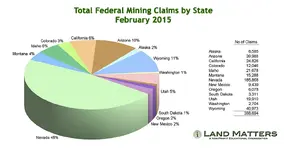
Mining Claims Graphs!

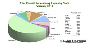
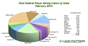
Finished up the graphics that show where the claims are being made.

I'm pretty sure these numbers don't fit the ideas most people have about mining in the United States. Obviously Nevada stands out as the prime mining state. What may surprise you is the strength of Arizona and Wyoming or the relative weakness of Oregon or Colorado.

It's obvious that lode claims are the primary form of mining claim by far. They represent about 84% of all claims in the United States.

More surprising is the percentage of placer claims in California. They are about 74% of all claims in California. California does have some pretty good placer deposits but by far the bulk of the mined minerals have been lode mines historically.

Here's the numbers to compare.
 

Attachments

  • Total_Claims_2015_feb.png
    Total_Claims_2015_feb.png
    90.3 KB · Views: 79
  • Lode_Claims_2015_feb.png
    Lode_Claims_2015_feb.png
    81.2 KB · Views: 75
  • Placer_Claims_2015_feb.png
    Placer_Claims_2015_feb.png
    94.3 KB · Views: 85
Last edited:

Top Member Reactions

Users who are viewing this thread

Back
Top