Prospectors Research Tools

Clay Diggins

Silver Member
Nov 14, 2010
4,958
14,509
The Great Southwest
Primary Interest:
Prospecting
Prospector's Research Tools

I haven't been around much this summer and with the desert prospecting season just starting it's a good time to show off what I did this long hot summer. I have been working with a few friends on a new non-profit organization to give you a single place for all your land research.

The result is MyLandMatters.Org. This is the gateway to your land information repository. Maps, books, tutorials, community resources and quality, easy-to-access information about the land around you.

No ads, No memberships, No log-in required. :thumbsup:

This past spring while sitting around with some friends we came to the conclusion that most of the important and useful things that we want to know about the land around us was difficult to locate and tough to understand. Despite the many sources of information there was no single place to find the information available.

We decided we could do something about that. We agreed to put our time and energy into creating a single place that anyone could find the answers to questions about the land.

It's a big project. It has taken a lot of work, learning and resources to get things started. But after six months of long days, and more than a few nights, the Land Matters repository is ready for you to use.

Land Matters is all about the land. You can find Land Status Maps, Active Mining Claims Maps (with live direct links into the current LR2000 claims database), A great collection of mining books, Land Laws, Geology books and maps, Forest Travel Plans and a whole lot more.

Land Matters is for land users. Our collections are guided by community input. That's you. Let us know what kind of material you would like to find in our Library or a particular map you would like to see. Help us build Land Matters to best serve the community.

We've already got a lot of things that prospectors have been asking for - the claims maps alone were almost universally requested. Land Matters isn't just for prospectors and miners. But you can help prioritize our efforts and drive the content of Land Matters. Prospectors now have a unique opportunity to help guide and build an information resource designed by prospectors and for prospectors.

We are just getting started filling the Library but there will be hundreds of books, maps and items added in the next few weeks. We've even got a Newsletter so you can get regular updates about new additions to the Land Matters repository.

Check it out and let me know what you think. Here are a few good places to start:

Tutorials - the current focus is on understanding Land Status.
Maps - We all like maps and we've got some you will love.
Library - search for something.

Heavy Pans
Barry & Leigh
 

Upvote 12
Well said bejay I have donated and supporting the Oklahoma geology map for 6 months

Thank you okbasspro. You, and several other members here, have provided great, and much needed, support to Land Matters.

By sponsoring the Oklahoma Geology Map you also helped your fellow prospectors. Now anyone studying Oklahoma geology can link directly into that map. No more donate window to click through. Users can make a favorite or bookmark and go directly to the map anytime they want or share the link. :thumbsup:

I was surprised how many people have been using the Oklahoma geology map. I have heard that there isn't much gold to be had in Oklahoma. okbasspro has proven that to be entirely wrong. This is one gold getting guy!

We will be meeting up with okbasspro this coming spring to meet the Oklahoma gold legend and thank him for his support in person. I hope the users of his Oklahoma Geology Map will thank him also. You might even consider walking in his footsteps. ;-)

Thanks Again

Heavy Pans
 

Thank you! :headbang:

So do you plan to do a land Matters Canadian version?:laughing7:

You are welcome Oregon Viking and thank you for your support.

Land Matters will be providing more information and mapping of Canada soon. We plan to eventually cover the entire world. That's going to take a lot of work and a lot of support from the land users community but we will get it done with your guidance and support. :thumbsup:

Heavy Pans
 

You folks have truly provided a wonderful and useful tool to the mining and prospecting community. I'm sure other user groups will catch on as well.
Thank you so much, a very Merry Christmas to you all.

If you ever get back this way, feel welcome to look me up.

Mike

You are welcome Mike and thank you for your generous support! :thumbsup:

Please let other land users know about Land Matters, we rely on users to guide our growth. We want to provide users with what they need and that's going to require feedback from all land using groups. We have already attracted the interest of several other groups. All are welcome.

We might just take you up on your kind offer Mike. Leigh has never visited your area of the country and my tales of the beauty there have her planning next summer's journey to include that area of the coast. Maybe in time for the Lily bloom? :laughing9:

Thank you again and a Merry Christmas to you!

Heavy Pans
 

We're thinking of moving back to Alaska. Sure would like to see some detailed maps of the Independence area down to Eagle River. Probably going to buy or build somewhere in that area again. Maybe up to Talkeetna. I need a good gold bearing stream where I can dredge and fight with the salmon again, hehe. I checked the Alaska map or world map and I know the area but everything helps :)

Thanks for the suggestion Reed. This is the sort of feedback that gives us our purpose. I'll see what we can find that will help you look over the area. I'll post to this thread as we add more information and maps.

Heavy Pans
 

I'm not sure what it would take to do it, but I was thinking that having the Topo map info come up in the window when you click on a section with the information cursor could be a very handy thing. That way someone doing research into an area would know the name of the map they need to download from USGS before they head out to an area. I know it would be a LOT of work since I've gotten over 110 maps for Mohave County so far and I'm only about 2/3 of the way done.

I'm currently working up my field kit version of all the management information by township/range and section and including which map(s) that info is covering. I'm currently about halfway done with the section from the La Paz county line all the way north to I-40. I'll do another one up in time for the areas north of I-40.

Here is a hint for anyone that is going to down load maps from the USGS site. If you want the PLSS data on the maps, DO NOT download the most current version!!! They have omitted that information on the newest maps. While the new versions come with an aerial view layer that can be turned on and off as needed, that got rid of the PLSS data. It doesn't make any sense to me, but I don't think it would have been much work to include it on the new versions. No one at USGS could give me an explanation as to why it's not included.
 

I'm not sure what it would take to do it, but I was thinking that having the Topo map info come up in the window when you click on a section with the information cursor could be a very handy thing. That way someone doing research into an area would know the name of the map they need to download from USGS before they head out to an area.

That's a good suggestion Jeff! :thumbsup:

That's very doable. We'll get to work on that and we should have it available this week.

Heavy Pans
 

GREAT! I was worried that with the massive number of maps for a single county, let alone the 12 entire mining states covered so far that it would be impossible to accomplish. Yet more proof that this is a he-11 of a team you've put together! I will still keep plugging away at my "Field Kit" but this will make it a LOT easier.
 

Thank you okbasspro. You, and several other members here, have provided great, and much needed, support to Land Matters.

By sponsoring the Oklahoma Geology Map you also helped your fellow prospectors. Now anyone studying Oklahoma geology can link directly into that map. No more donate window to click through. Users can make a favorite or bookmark and go directly to the map anytime they want or share the link.
I was surprised how many people have been using the Oklahoma geology map. I have heard that there isn't much gold to be had in Oklahoma. okbasspro has proven that to be entirely wrong. This is one gold getting guy!

We will be meeting up with okbasspro this coming spring to meet the Oklahoma gold legend and thank him for his support in person. I hope the users of his Oklahoma Geology Map will thank him also. You might even consider walking in his footsteps. ;-)

Thanks Again

Heavy Pans
Clay i am just a regular guy that likes to dig in the dirt. I am very thankful for all the people that share great info on this site. I try and pass on what I can to people when I am out I like to see new people enjoy the outdoors and show them that while I have 1000s in equipment they can take a 4 dollar pan and find some color. Again I can not thank you enough for the help Clay I hope you and yours have a great Holiday season.
 

Good gods you folks did a huge amount of work. Thank you. It duplicates parts of my web site.
 

Good gods you folks did a huge amount of work. Thank you. It duplicates parts of my web site.

There is a lot more coming Desertphile! Let us know what you would like to see next. There are just two of us to do the website and mapping but I'm guessing that's twice as many people as you have?

Let me know if we can share any info to help your project along. :thumbsup:

Heavy Pans
 

GREAT! I was worried that with the massive number of maps for a single county, let alone the 12 entire mining states covered so far that it would be impossible to accomplish. Yet more proof that this is a he-11 of a team you've put together! I will still keep plugging away at my "Field Kit" but this will make it a LOT easier.

Jeff at this point we have built a prototype map that gives access to more than 26,000 current and historical topo map downloads. We think we can do better than that. Look for a new "map of maps" in the next few days. :thumbsup:

Heavy Pans
 

Active Mines and Mineral Processing Plants

Land Matters has several new research tools coming your way over the next few days.

I thought we could get started with a new mining map the United States Active Mines and Mineral Processing Plants Map.

This one shows the mines, mineral processing plants and the combined operations that have both mines and mineral processing functions. These features vary all the way from your local gravel pit or sand pile all the way up to the big open pit mines and smelters. Lots to look at on this map and it includes information details like what is being mined or processed and the company that owns the operation.

Look around your own neighborhood - you might be surprised at whats just around the corner. :thumbsup:

Heavy Pans
 

Now that will be interesting! I know that the local sand and gravel plant is sitting on a placer deposit but I am unsure what if any recovery they do. I also know of a smallish Gypsum mine a few miles further out Hwy-80 from us. Would be cool to find out what else is in the area.
 

Barry,

Are there any particular fault lines that would be beneficial in exploring? There are regular, long fault lines and then I find sections that are like zig-zags where the faults intersect. These faults are in a granitic area with abundant pegmatites. I'm a placer miner primarily and I'm just getting into mining hard rock areas.-Luke

Good question Luke. :thumbsup:

As usual there aren't any simple answers but I'll take a shot at a brief version. :icon_scratch:

Faults are often found at the junction of different types of rocks. These are the faults that first get my attention. All faults within the right rock may have potential but those created by adjoining rock types often are more productive.

Different types of rock have different chemistry, different hardness, different porousness, different heat potentials. These differences cause fault zones to raise the pressure and the heat on the rocks nearest them.

This allows certain chemical reactions between the rock masses. Those reactions can cause particular metals and salts to segregate themselves into relatively pure concentrations in zones where the conditions are best in the fault zone. These are the mineralized zones that produce the crystals and metal we are looking for.

Depending on what those metals combine with (or not) and the chemistry and pH of the surrounding rock these concentrations can take many different useful forms.

For the Pegmaties you will often find the best crystallization nearest the fault zone but the largest crystals will be found in the area of most rapid cooling and pressure loss. The best area might be further away from the fault, if so follow at that distance from the fault when looking for more of the same.

Gold can be concentrated in particular types of chemistry involving base fracturing and high pressure/heat solutions. Gold could also migrate and concentrate in "sponge" rock near high heat and pressure zones. Each situation is different in the specifics but the principles of higher heat and pressure are often the common factor.

There are a zillion different situations that can take place along these fault zones. Try to find the two rock types on either side of a fault that have produced the best gems or metal concentrations, note the conditions in those best areas and try to find similar situations further along the fault or on a different fault that has similar rock types.

The more fractured the fault line is itself the more pressure it is under. This can be a good thing for mineralization but it can make the mineral locations difficult to find. The minerals tend to be in isolated pockets that may have little in common with nearby areas. Remember that these faults are rarely straight up and down in the earth. When the fault itself has been folded and broken up things can get very confusing when you can only see what's on the surface.

I hope that helps Luke. Faults are a "deep" subject that when well understood can help your prospecting success immensely. :laughing7:

Heavy Pans
 

Last edited:
Thank you so much!

The area is described this way:

Complex of intertonguing rock types including migmatite, granitic gneisses, monzonite, quartz diorite, greenstone, mica and hornblende schists, abundant granitic pegmatite. As well as Amphibole schist.

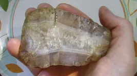
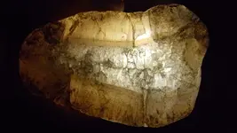
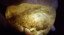
I've found numerous interesting minerals from the placer deposits of this area including some Beryl, amazing fist-sized clean agates and other interesting minerals.

This is one of the agates:

125_2176.JPG

125_2110.JPG

Back side:

125_2114.JPG

I've never found agates that clean anywhere but here.
 

Last edited:
More than 1/4 Million Topo Maps at the Click of your Mouse!

I'm not sure what it would take to do it, but I was thinking that having the Topo map info come up in the window when you click on a section with the information cursor could be a very handy thing.

Well it was pretty easy to put up a topo map index but that didn't seem particularly useful, the user would still have to go find the download themselves.

After a long week of coding we've finally come up with the mother of topo map download searches. All you need to do is click on the map in your area of interest to get links to all the topos ever made for that area.

This new map gives you access to all the historic topos as well as the new digital topos. These historic topographic maps will can give you real insight into the history of an area. Some were published as long ago as 1882 and many of them show houses, mines and roads no longer shown on the modern topo maps.

A total of 265,486 topo maps are now available at Land Matters Topo Map Downloads page.

Get the sets for your area of interest and get a big head start on your research. :thumbsup:

Lots more coming this weekend!

Heavy Pans
 

Absolutely amazing. I can only imagine what an aid your site would have been to us in the land surveying business just a few years ago. All of the information was available but was very cumbersome, time consuming and often costly to obtain.

One thing I've been waiting on for a long time, is digital online copies of the original PLSS survey field notes pertaining to California. In this state, the last time I tied to access them, they had not been compiled yet by the government. There is a lot of unique information in these notes which is found no where else.

Mike

Thanks Mike, and thank you for your support of Land Matters! :thumbsup:

We've been working on the surveys for California for several years. They are supposed to be moved over to the Government Land office so we can have public access. Occasionally we can find a few there but most of them are still stuck in limbo in California. Same thing with a lot of the Patent records. We keep hoping for a big update but we haven't seen it yet.

When those records do become available we will put together a map that will let you access them direct. It's part of a project we are working on for all the states. It just seems right to us that everybody should have access to the surveys that define the legal description of the land.

Heavy Pans
 

Mining Claims Video!

Land Matters has been getting a huge number of hits on their Mining Claims Maps. So many hits that the Mining Claims Maps have their own page now!

To help accommodate all those map users we've put together a video to help users get more value out of those maps. You can watch that video here or better yet why not go to the site so you can watch the video while you work on your own copy of one of the mining claim maps. :thumbsup:

Click HERE for Video and Map.


Heavy Pans
 

Top Member Reactions

Users who are viewing this thread

Back
Top