Property knowledge help.

fetcher

Jr. Member
Sep 24, 2011
82
22
Maryland
Primary Interest:
All Treasure Hunting
Hey guys. I want opinions. Lately, I've been researching the best places to metal detect for gold in California, and have a few good spots, but the spots are huge tracts of open land. I mean huge. Some are at the base of mountains. Some are literally 20 miles from civilization. Here are my questions:

1. How do I find out who owns it?

2. How would anyone know if I parked my truck 5 miles away from my target site and went off into the woods with an ATV. It's not even close to civilization... ? Not saying I'm going to do this, but I feel like it's so sparse out there, no one would ever know especially if I am 5 miles into the mountains.

3. If BLM does own it, am I allowed on it as long as it's not some historic site or national park?

Just curious.
 

Upvote 0
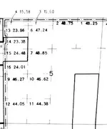
Here is an example for you Clay Diggins, if you care to help out a beginner. This attached image was titled "Government lot" under "division". Does that mean this entire section of the map is a no go? If it's up for mineral "grabs" why do certain sections have zero writing in them like section 27?View attachment 1442649

It would really help your understanding if you studied the Tutorial on MTPs I offered.

Government Lots are the irregular portions of the Public Land Survey. Government lots are designated on the PLSS and MTP by numbers (Like L4) instead of direction (like NENW).
In this image of Section 5 from the partial MTP you showed the Lots are numbered as high as 16 and each lot number has an acreage written to the right of the Lot number.
Screen Shot 2017-04-24 at 7.58.50 AM.png
Regular aliquot quarter quarters of 40 acres are not shown on the MTP but anything out of the ordinary is included. Lots are bigger or smaller than aliquot parts of the survey so they are shown.

The MTP is not a distance and direction map it's a map of land status. The only features on the map are land status notes. Notice that on the sample I included above there is a dotted and dashed line? That's a holding line that describes a land status unit. Being that it's got dashes and dots it's a form of withdrawal - not necessarily mineral withdrawal. The MTP will tell you what that withdrawal is but you cut off the portion of the map that shows the Land Order that describes the withdrawal. I'm guessing the line describes the National Forest Boundary but without the whole MTP there is no way to tell if that's the case.

The Tutorial shows just that type of dot dash line in section 15 and includes this note:
Withdrawn and classified lands - always always examine the withdrawal order to determine the segregative effect on mineral location and mineral leasing.
Section 27 and the other open sections have no lots, surveys, rows, patents etc so they don't have any notation in them. Section 27 is still within the dot - dash line so it is affected by whatever land status is indicated.

Take some time to look up, in the tutorial, each feature symbol on your MTP. Soon you will come to recognize each feature for it's meaning and the MTP will make a lot more sense.

Heavy Pans
 

It would really help your understanding if you studied the Tutorial on MTPs I offered.

Government Lots are the irregular portions of the Public Land Survey. Government lots are designated on the PLSS and MTP by numbers (Like L4) instead of direction (like NENW).
In this image of Section 5 from the partial MTP you showed the Lots are numbered as high as 16 and each lot number has an acreage written to the right of the Lot number.
View attachment 1443460
Regular aliquot quarter quarters of 40 acres are not shown on the MTP but anything out of the ordinary is included. Lots are bigger or smaller than aliquot parts of the survey so they are shown.

The MTP is not a distance and direction map it's a map of land status. The only features on the map are land status notes. Notice that on the sample I included above there is a dotted and dashed line? That's a holding line that describes a land status unit. Being that it's got dashes and dots it's a form of withdrawal - not necessarily mineral withdrawal. The MTP will tell you what that withdrawal is but you cut off the portion of the map that shows the Land Order that describes the withdrawal. I'm guessing the line describes the National Forest Boundary but without the whole MTP there is no way to tell if that's the case.

The Tutorial shows just that type of dot dash line in section 15 and includes this note:

Section 27 and the other open sections have no lots, surveys, rows, patents etc so they don't have any notation in them. Section 27 is still within the dot - dash line so it is affected by whatever land status is indicated.

Take some time to look up, in the tutorial, each feature symbol on your MTP. Soon you will come to recognize each feature for it's meaning and the MTP will make a lot more sense.

Heavy Pans

Thanks again. Your knowledge is impressive. Do you mine for a living?
 

Interesting. I don't have a specific county in mind, but I do have a question for you. Did you buy the land you are mining or did you buy the mineral rights?

Sorry, apparently my message never made it through.
The answer is both. I have a claim as well as private property.
I don't get too serious about my mining activities due to the expense related to state/local requirements.

It would be difficult to make a good living mining unless it was at a large scale. You always feel like you are making good money, but that is because you are conveniently forgetting all of the related expenses.
I do believe with a strong body, you could survive by prospecting and living off the land.
For me it is just a hobby/enjoyable way to make extra money.

Recreationally speaking, there is no shortage of open ground available to claim or simply prospect.
If you want a claim on a river or large creek, that is a different story.
 

Clay the service and information you provide is of the utmost value for all to utilize ! BUT (for me) I'm 70 and at the end of my prospecting / dredging days. I'm to old and beat up to do much of anything anymore .I'm glad if I have helped anyone over the years of me running my mouth off !! I'm real close to going out with my (now)2 inch dredge and at least give it one more try , but going up them hills from the stream is going to be my problem and getting to a standing position after dredging is the other ! I've had the pleasure of meeting many great people over the years and DONT regret 1 bit of it!!! Plus driving across our Country is getting out of hand for me. I hope the BEST for everyone and hope they hit their "Glory Hole"!
 

Top Member Reactions

Users who are viewing this thread

Back
Top