(Pics) mine w/ chestnut burr above..(New link to Video)

Re: (Pics) mine w/ chestnut burr above

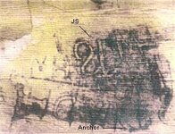
ki, big paint creek, between west liberty and paintsville, rt. 460. on rockhouse branch of paint creek, there is a round rock near the large rockhouse on that branch that had several carvings. one was a triangle with a turkey track in side it, pointing west. and next to it is a JS but reversed. like the one below. also another anchor. why is the JS backwards. also at the mouth of paint creek a slanted rock was found with strange carvings on it and a map. there is a newspaper story on this and a photo. i hope i can find it. west liberty library had one. they can't find it.
 

Attachments

  • JS rev..jpg
    JS rev..jpg
    16.4 KB · Views: 1,250
Re: (Pics) mine w/ chestnut burr above

heyhey,

So....whats the word on ppl getting together, in Grayson Lake Park.

Has anyone ever ran across any info on southern Lawrence Co. KY(Louisa) and the Laurel creek area in Johnson County around Flatgap, KY while researching.
I had an interesting conversation with a pleasant old guy from that area that told me an interesting story about his great-great Grandfather and him finding a perfectly formed 4 to 5" by 3" bar of silver.
in that creek back in 1800's. He also told me of a cave that his great-Grandfather and Grand father used to visit to get lead from it to make thier own bullets for the guns of that time. It was a very interesting story.
Although he did not now the exact location of the cave he did tell me the area that it was in from stories his Grandfather told him. He also mentioned this cave had a rock in front of the entrance if that has any value.
I am new to this Swift legend and was wondering about this info.....let me know..thnx KW
 

Re: (Pics) mine w/ chestnut burr above

Boomer-
Ok, i know the Paint Creek spoke of now, its located in a good area. Appears to be very close to a branch of the Warriors path (Buffalo trace). The more i read of the description above, the more it sounds like the mine I've found. Where it talks about silver ore, could it be a vein or deposit 150ft by 70??? humm.... or maybe just measurement of shaft...interesting!
 

Re: (Pics) mine w/ chestnut burr above

The JS reversed could be the particular marks Swift mentioned cutting on his way to and from the area of the Mines. Only Swift and the crew members with him would of knew what the marks where, a Indian or another long hunter would have Trouble figuring out what the marks ment or who cut them. Just a thought...
 

Re: (Pics) mine w/ chestnut burr above

UpTheCreek,
There is mention of Swift's richest mine being behind a fallen boulder or rock. Ive also heard a story or to that the Shawnee Cave has a rock in front of its small entrance. "google" search John Swift, read everything you can find, the clues will present themselves in the journals and research. Your in a good area :thumbsup:
 

Re: (Pics) mine w/ chestnut burr above

Ki, your mine entrance does appear to be cross-shaped. But from another perspective it resembles St. Mark, the winged man. If so,then this is probally a Spanish site. There should be hidden numbers carved there representative of certain Bible verses. There should be other hidden messages there-step back and take a broader more careful look at different times of the day. Notice what is there and if there are any other funny shaped rocks nearby-are there any turtle or other animal shaped rocks nearby? Could there be a pozo or plug hiding another entrance into this place? Be wary.
 

Re: (Pics) mine w/ chestnut burr above

http://www.treasurehuntersuniversity.com/treasure_symbols.html

The link above has a few carvings Ive seen around this area, esp, the Swastika carving.... also it has the symbol of the cross carving boomer posted a few days back.... Could be Spanish, the Cherokee were known to work these same mines.
 

Re: (Pics) mine w/ chestnut burr above

Also in the link above look for Indians, in the box on the top lefthand side... good story about the way Indians would of hid things.
 

Re: (Pics) mine w/ chestnut burr above

Ki, i hope to have this story completed this week and put it in on a new post. one part is odd and interesting. the manuscript they were using said> they went from somewhere on the little sandy river to its headwaters and crossed over a flat land into wolf county to a certain stream and came up on a peculiar large rock described in the document. some of the papers story i'm just going to have to guess at. i do have partial words. that helps. odd about being on the little sandy. why?? i hope the copies i pick up tomorrow will help.
 

Re: (Pics) mine w/ chestnut burr above

boomer said:
ki, big paint creek, between west liberty and paintsville, rt. 460. on rockhouse branch of paint creek, there is a round rock near the large rockhouse on that branch that had several carvings. one was a triangle with a turkey track in side it, pointing west. and next to it is a JS but reversed. like the one below. also another anchor. why is the JS backwards. also at the mouth of paint creek a slanted rock was found with strange carvings on it and a map. there is a newspaper story on this and a photo. i hope i can find it. west liberty library had one. they can't find it.
It could be because the JS is reversed, so are the directions. So west is East. Used to throw off other parties..
 

Re: (Pics) mine w/ chestnut burr above

I have a question... where is it mentioned by Swift that the French "castle" is north of him and the "york" river is south? I have an idea...
 

Re: (Pics) mine w/ chestnut burr above

Swiftfan,
on his way to the mines, i believe
 

Re: (Pics) mine w/ chestnut burr above

I find it strange that Stoner, Cleavland, and any of the others did not make mention a lot about the mines in correspondence with some one else...bet someday we find it in something like the Draper Manuscripts (only still in private hands)...maybe someone is just keeping it because it has an autograph on it they like, but the letter contains something about the mines. If any one findsit bet it will be Boomer...research, research, research! The key to finding treasure.
 

Re: (Pics) mine w/ chestnut burr above

Curtis/Ki: Curtis, the draper manuscripts from what i have seen are second, third hand information, most seem to be a collection of notes. some taken out of early history books.

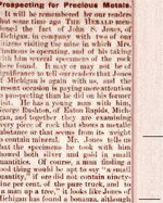
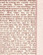
Ki, below is another article on wolf county. in some stories Mrs. Timmon's died and never found anything. but than something pops up like the story below. one lady told me, oh, she had money. my granddad looked for timmon's cache. he said it has to be near the mine or her old house. so far all references to the different mine stories puts it north of the north fork of the red river.
part of this story was in an old paper clipping a guy had, but it was cut to close on the sides and bottom. but you can make out most of it.
 

Attachments

  • timmins 1.jpg
    timmins 1.jpg
    227.2 KB · Views: 1,116
  • timmins 2.jpg
    timmins 2.jpg
    199.5 KB · Views: 1,088
Re: (Pics) mine w/ chestnut burr above

Good stuff! Wonder what "Herold" its talking about...it seems like somebody recently posted that they knew the exact location of the lady's farm and the arch named after her...gave the coordinates too.
 

Re: (Pics) mine w/ chestnut burr above

Are you looking for the coordinates to Timmons Arch?

TIMMON'S ARCH 37°47.408'N -83°34.1'W
 

Re: (Pics) mine w/ chestnut burr above

Found a small write up. it has to do with some new york people finding a large lead vain near Mrs. timmons Arch where she was searching for the swift silver mines.
 

Re: (Pics) mine w/ chestnut burr above

Curtis, last year i done alittle research on Michael Stoner, i was shocked to learn that he was Dutch... By him being Dutch, things he would have told people would not have been recorded, the colonials looked down on people like the Dutch, so their story's and history ment nothing, and were never recorded. This could probally explain alot of the gaps we seem to have in our history today.

Boomer, thats a great read......thanks for posting it
 

Re: (Pics) mine w/ chestnut burr above

I believe both Henson and Steely give directions to Timmons mine, however this is not the area i am in with my mine. But i do have a post in the GPS help topic, with a map of its location.
 

Top Member Reactions

Users who are viewing this thread

Back
Top