gollum
Gold Member
- Joined
- Jan 2, 2006
- Messages
- 6,770
- Reaction score
- 7,734
- Golden Thread
- 0
- Location
- Arizona Vagrant
- Detector(s) used
- Minelab SD2200D (Modded)/ Whites GMT 24k / Fisher FX-3 / Fisher Gold Bug II / Fisher Gemini / Schiebel MIMID / Falcon MD-20
- Primary Interest:
- All Treasure Hunting
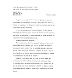
Erwin Ruth himself hired an investigative team to search out all known materials about the PEG LEG Mine look above and you will see it clearly states the PEG LEG and no other mine is mentioned. The Ruths were no where near where they claimed to be, they were miles west of NorthEastern end of Borrego Mountain.
http://www.lost-dutchman.com/dutchman/robtwo/ruth.pdf
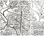
Hate to burst your bubble, but they weren't. They started at Warner Hot Springs, came down Grapevine/Sentenac canyon, through The Narrows, out onto the Borrego Flats. They followed the course of San Felipe Creek to Borrego Mountain Area. They camped to the West of BM. Adolph Ruth took off towards BM because that is where his map indicated the mine was. In trying to get to the mountain, as it was beginning to get dark, he fell into a very steep arroyo, where he laid for almost four days until he was rescued.
.....and again, they were not looking for the Peg Leg!
This is from YOUR source:
Another interesting point about this letter is that it appears that it was Glenn Magill who injected the “mythical” connection of the mine that Adolph and Erwin were looking for to the “Lost Peg
Leg” by his remarks:
“Supplementing my report to you on the Peg Leg. ...” (Pg. 1, Par. 1, ln 1)
and
“Although these hills are requisite and perfectly match his [Peg Leg Smith] description,
(they also fit the description you supplied me on the hills you and your father saw)...”(Pg.
1,Par: 6 ln 1-2)
and
“I am almost convinced that this range is the one you described to me, and it fits
perfectly with other information I have on the Peg Leg”(Pg. 1,Par: 7 ln 1-2)
There are several books which perpetuate this connection including (1) Borrego 13 (the story of
Gene Reynolds search for the Lost Peg Leg AND the Adolph Ruth’s mine) by Gene Reynolds
who seems to have gotten his information from Glenn Magill and (2) Superstition Mountain, A
Ride Through Time (page 48) by James Swanson and Tom Kollenborn who references Borrego
13 as their source.
If you are going to do some research, then please finish the job. Glenn Magill drew a map based on Erwin Ruth's description, and Ruth verified that the map was accurate:
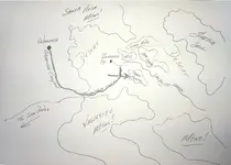
As you can see, the path Adolph and Erwin took is EXACTLY as I stated previously. I have been through the area (literally) hundreds of times. There is not a 100' square patch of that entire area I have not put a foot on. The arrow points directly at the Northwestern end of Borrego Mountain. This is the location of the mine I previously posted the pictures of, and again, it is not the Lost Gonzales Mine.
Mike
Last edited:


