dog the treasure hunter
Gold Member
- Jan 16, 2011
- 5,010
- 5,039
- Detector(s) used
- Time to move on. Good luck everyone .
- Primary Interest:
- All Treasure Hunting
Have to use a smiley to start posting.
Follow along with the video below to see how to install our site as a web app on your home screen.
Note: This feature may not be available in some browsers.

Have to use a smiley to start posting.
Ok , back on track
I promised to use some Maps in a prior post .
I think today , that I'm a bit too lazy to boot those up .
so I'll walk us through with directions using text .
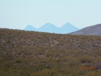
Pedro Directed that : Upon " First " sight of these three small Peaks , turn into the Gap Between the Scattered Mountains ,
Heading toward the Caballo Peak .
( again , Cookes Peak's South Face , has the appearence of a Horses Face ( Caballo=Horse )
That Gap , is currently referred to on USGS Maps as " Starvation Draw " as I showed DTTH while we visited .
the Three Peaks are the Tres Hermanas near the Florida Mountains which block the View from the Camino Real of the
three Peaks .
" Look for the Large Spring , do not be Mistaken , for there are other smaller springs , but this is the Largest "
That is now a Rectangular shaped Water Tank at the base of Pony Hills where the First Petroglyphs are located .
( Actually , the first Petros connected to his directions are west and south a bit from Pony Hills , not yet photographed
and posted here )
Several other Petro sites as well , but he keeps us directed to the Four Sites which the others refer to .
Enjoying this ?
Good , I am too , feels good to get this out of me .
whew , like a Skeleton from the closet Man .
I'll get to some Maps , using USGS mostly .

People are afraid Bad Puppy. They dont want to be Blackballed like you. Some are not as strong as you. They cant walk the path alone. Your Writings are very interesting, i see why people take it. Where else can you get these Truths. I follow your posts for a very long time.
