mikhen
Jr. Member
The Berks County link has changed. It is now http://www.co.berks.pa.us/Dept/Mapping/Pages/GISParcelViewer-InteractiveWebMaps.aspx
Follow along with the video below to see how to install our site as a web app on your home screen.
Note: This feature may not be available in some browsers.
kayden said:OK now im gonna beg...Please put up Clearfield county (if its availible)....thanks in advance!
Thanks Jeff for the info, However thats outta my budget to find indian heads & wheaties!jeff of pa said:kayden said:OK now im gonna beg...Please put up Clearfield county (if its availible)....thanks in advance!
unfortunately it looks like Clearfield wants $$
DIGITAL GIS DATA...
At the present time we do have various digital GIS data available for purchase in ESRI Shapefile format. These shapefiles include, but are not limited to:
Street Centerlines
Private Roads (Driveways, gas well roads)
Addressable Structures (No resident information)
Outbuildings (Barns, garages, sheds, etc.)
Hydrography (Water features)
Railroads
Cemetery Locations
Municipal Boundaries
Parcel Data
Parcel Data maintained by the Clearfield County Assessment Office is also available for purchase in ESRI Shapefile format. Prices for parcel data are as follows:
Parcel Polygon and Parcel Id Number - $.02 per parcel
Parcel Polygon and all associated tax data - $.05 per parcel
A minimum charge of $20.00 applies to all orders.
At the present time there are nearly 70,000 parcels in Clearfield County. We do offer a reduced rate for bulk purchases of parcel data.
Entire County, Parcel Polygon and PIN Number - $1,200.00
Entire County, Parcel Polygon and all tax data - $3,000.00
http://www.gis.clearfieldco.org/digitaldata.htm
Does anyone know of the gis services for Warren County? All I know is they have at the county courthouse. Oh, and are county courthouses off limits to search? Thanks in advance...
The page for Centre County wasn't working.
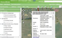
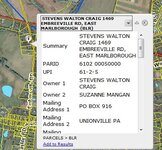
The Chester one is not that easy to use.


| UPI: | 61-2-50.2M | PLAN NUMBER: | |
| PIN: | 6102 005002M0 | LUC: | R-10 SINGLE FAMILY/CABIN |
| Street Number: | 952 | Street Direction: | |
| Street Name: | UNIONVILLE WAWASET | Street Type: | RD |
| Situs Address: | 952 UNIONVILLE WAWASET RD | MAILING ADDRESS: | 952 UNIONVILLE WAWASET RD |
| OWNER(S): | BULKLEY ROBERT A | KENNETT SQUARE PA | |
| DEBORAH J | |||
| LOT LOCATION: | SS OF UNIONVILLE WAWASET R | ZIP: | 19348 |
| PROPERTY DESCRIPTION: | 1.1 AC & DWG LOT 39 | BOOK: | 6120 |
| ACRES: | PAGE: | 1743 | |
| SQUARE FEET: | 47916 | DATE OF RECORDATION: | 04-14-2004 |
| LAST SALE PRICE: | 292000 | TOTAL ASSESSMENT: | 199500 |
| ASSESSMENT DATE: | 12-19-2014 | Lot Assessment: | 55670 |
| Municipality Number: | 61 | Property Assessment: | 143830 |
| Owner Name | Deed Volume | Book | Page | Sale Date | Sale Price | Lot Location | Prop Description | Total Assessment |
|---|---|---|---|---|---|---|---|---|
| BULKLEY ROBERT A & | 6120 | 1743 | 04-14-2004 | 292000 | SS OF RT 842 | 1.1 AC & DWG LOT 39 | 199500 | |
| SOLON ERIC G & | 4617 | 1676 | 08-12-1999 | 229900 | SS OF RT 842 | 1.1 AC & DWG LOT 39 | 199500 | |
| SIDELL MARK W & | 4287 | 906 | 01-13-1998 | 188500 | SS OF RT 842 | 1.1 AC & DWG LOT 39 | 199500 | |
| SPAID ARTHUR H & | K | 54 | 333 | 01-01-1979 | 16500 | SS OF RT 842 | 1.1 AC & DWG LOT 39 | 199500 |
Try this
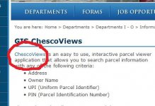
Chester County, PA - Official Website - GIS ChescoViews
then Click ChescoViews
View attachment 1205715
then
scroll down to I ACCEPT
it should give you the interactive map.
I adjusted it on the Mane page too