One way to find the Mother Lode

Goodyguy

Gold Member
Mar 10, 2007
6,489
6,900
Arizona
Detector(s) used
Whites TM 808, Whites GMT, Tesoro Lobo Super Traq, Fisher Gold Bug 2, Suction Dredges, Trommels, Gold Vacs, High Bankers, Fluid bed Gold Traps, Rock Crushers, Sluices, Dry Washers, Miller Tables, Rp4
Primary Interest:
All Treasure Hunting
For the novice prospectors,

When you are in gold country, always have a pan with you especially on creeks rivers and streams test pan every 100 yards or so, once you start to find color mark the bank. (stack some rocks up)

Now test pan every 25 feet or so and keep test panning up stream until the color runs out and mark the bank again.

Go back to where the pay streak was best and that's the place to set up your high banker or dredge later on.

Now start working your way up the side of the hill on the bank side of the water that produces color by digging and test panning in a narrowing triangle from your first and last marks on the bank up the hill or mountain always keeping the richest part of the pay streak in the middle, keep digging and test panning on up the hill or mountain until you find the source. Eureka! you found the mother lode to the placer gold you have been panning. Now you have a place to hard rock mine. Of course that may just be a pocket but so what. :thumbsup:

Just make sure you are not on someone elses claim first.


GG~

It wont usually wash down as pictured it will twist and turn depending on the terrain but you get the idea.

Blue is water source.
Black squares are test holes.
gold circles are gold deposits.
X marks the source lode.
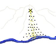
lode.jpg
 

Last edited:
Thats what the book says to do ....but if it were only that easy! :wink:
 

Easy.......Nooooo way.

That's a lot of digging and carrying bucket after bucket load of material back to the water to pan.
Up and down the hill more digging and more panning. And on and on.
Not easy at all...if it was we would all be rich. ;D

It would be easier with a 4 wheeler though :thumbsup:


GG~
 

HI my friends, if there is AG, Cu, or pb etc associated with the gold, use a geo chem test kit. much simpler, less work and far more efficient, i.e more senstitive. Cheap too, just like me.

Don Jose de La Mancha
 

we newcomers really need you old timers to cue us in. this is valuable advice I think. A shame it is not repeated more often.

Thanks! :hello2:
 

GReat Info... except that ANY area worth working in MOST areas is already claimed/on private property, and also, most of the best gold was got by the cream croppers years ago.
But anyones who's been in gold country knows, it's hard to miss, and placer gold will be there, no matter how small ammount.
So, what to do with this information? GET permission from land owners, explain the geography and the loot share system. If they don't really care, but make you sign a no holds harm clause, than go for it.. that means if you get hurt on thier land, they can't sue you.. .
THen, you pay them in solid gold... Win win.

Otherwise, don't get caught with a gold pan in a national forest( illegal) OR don't get caught on private property... End of story. P)
 

uh- not exactly Fires Eye. National Park maybe not, National Forest- depends:

"Where May I Prospect?"

There are still areas where you may prospect, and if a discovery of a valuable, locatable mineral is made, you may stake a claim. These areas are mainly in Alaska, Arizona, Arkansas, California, Colorado, Florida, Idaho, Louisiana, Mississippi, Montana, Nebraska, Nevada, New Mexico, North Dakota, Oregon, South Dakota, Utah, Washington, and Wyoming. Such areas are mainly unreserved, unappropriated Federal public lands administered by the Bureau of Land Management (BLM) of the U.S. Department of the Interior and in national forests administered by the Forest Service of the U.S. Department of Agriculture. Public land records in the proper BLM State Office will show you which lands are closed to mineral entry under the mining laws. These offices keep up-to-date land status plats that are available to the public for inspection. BLM is publishing a series of surface and mineral ownership maps that depict the general ownership pattern of public lands. These maps may be purchased at most BLM Offices. For a specific tract of land, it is advisable to check the official land records at the proper BLM State Office.
 

Ah, thanks for the information. I did not know about the gold in florida, but it does not surprise me.
Heck, what about all the gold in the ocean water... if there were only a cheap way to electrically condense the gold in seawater... oh the joy... Try claiming the ocean :)
I've heard something like 1 ounce of gold per square mile of sea water, or maybe it's 100 acres or so.. Anyone know?
Better get your claim ont eh ocean in now, before the technology becomes readily available :icon_sunny:
 

I clipped that from a USGS website.

You actually have a good idea. With the water wars heating up many communities are turning to desalination. Desal uses filters. Those filters must need to be cleaned periodically. You could start a business and get paid to clean the gold out of their systems. I would think it would work at dentists offices as well. (sorry if I strayed too far off topic :dontknow:)
 

FiresEye said:
Ah, thanks for the information. I did not know about the gold in florida, but it does not surprise me.
Heck, what about all the gold in the ocean water... if there were only a cheap way to electrically condense the gold in seawater... oh the joy... Try claiming the ocean :)
I've heard something like 1 ounce of gold per square mile of sea water, or maybe it's 100 acres or so.. Anyone know?
Better get your claim ont eh ocean in now, before the technology becomes readily available :icon_sunny:


The only gold your going to find in Florida will be on the beaches in the form of jewelry or Spanish ship wreck treasure washed ashore after a major offshore storm.

The reason you can stake a claim in Florida is because of the many other minerals located there, unfortunately precious metals are not on the list.


Skip
 

I HOPE YOU GUYS ARE NOT CARRYING FULL BUCKETS FROM A HILLSIDE TEST ALL THE WAY DOWN TO THE WATER POINT TO PAN. TRACING IS VERY TEDIOUS WORK BUT NOT THAT HARD. GET YOURSELF A DAYPACK, 6 INCH PAN, A SPOON AND CARRY A GALLON OF WATER WITH YOU. YOU WILL NEED A NOTEPAD AND PENCIL. KNEEPADS HELP SOMETIMES. START WHERE YOUR GOLD STOPS AND GO UP THE HILL OUT OF THE FLOOD RANGE. IF YOU STILL HAVE GOLD THEN START DIG 1 AND REMOVE ANY VEGETATION AND TAKE JUST A SPOON FULL SCRAPE ACROSS THE TOP AND PAN THIS OUT RIGHT IN FRONT OF YOURSELF. COUNT THE COLORS IF ANY AND YOU NEED TO TRY AND BE EXACT AS YOU CAN. IF YOU GOT COLOR OUT OF DIG 1 THEN GO TO DIG 2 ACROSS AND UPSLOPE BUT ONLY ABOUT 6 INCHES. DO THE SAME THING AND KEEP A GOOD COUNT. MARK ALL RESULTS DOWN IN YOUR NOTEBOOK. CONTINUE TO DO THIS UPSLOPE AND IF YOU INDEED ARE ON A GOOD TRACE YOU WILL SEE MORE COLORS TO THE PAN AND THE CORRIDOR WILL NARROW DOWN. IF AT ANY POINT THE NUMBER OF COLORS OR DIRECTION CHANGES SO DO YOUR DIGS. THIS HOPEFULLY WILL LEAD YOU TO A NICE LITTLE SEAM. THE PROBLEM IS USUALLY THERE ARE MANY SEAMS ENRICHING A PARTICULAR AREA. THIS IS WHERE IT GETS VERY TEDIOUS TRYING TO NARROW THEM DOWN , HOWEVER IT CAN BE DONE. I HAVE DONE IT OVER THE YEARS. THIS IS VERY TIME CONSUMING AND YOU MUST BE PATIENT BUT THE FIRST TIME YOU DIG INTO THE SIDE OF A HILL AND HIT A NICE SEAM IT ALL COMES TOGETHER AND YOU ARE REALLY READY TO TRY AND LOCATE ANOTHER. I AM TALKING ABOUT FINE GOLD PRIMARILY. I HAVE USED MY DETECTOR IN NORTHERN CALIFORNIA AREA TO FIND COURSE POCKETS, AND YES THEY DO EXIST. I HAVE FOUND SEAMS THAT HAVE PAID OFF WITH AS LITTLE AS 2.4 OUNCES OF FINE , ALMOST INVISIBLE GOLD AND ONE POCKET AS LARGE AS 13.7 OUNCES OF THE SAME FINE GOLD. GOLD IS GOLD . I HAVE ALSO DUG ONE HELL OF ALOT OF SAMPLE DIGS FOR WEEKS AND WEEKS AND NOT FIND ANYTHING. MOST GOLD WHEN IT IS SHEDDING WILL TEND TO STAY TO THE SURFACE AND NOT GO DEEP WHICH IS WHAT MANY NEWER PROSPECTORS DONT UNDERSTAND. I HOPE THIS WILL SOME OF YOU IN YOUR QUEST FOR THE YELLOW. ......well its not always yellow so watch for the heavies depending on what your local alloys are. TRINITYAU.
 

I've been to the Stanislaus Natl Forest ranger station near Arnold, CA. Metal detector... go for it. Panning... go for it. Sluicing... by permit (notice of intent). NO, NADA, indian artifacts. TTC
 

notice of intent is only required for claims...if are going to cause a surface disturbance beyond normal forest use levels and especially if you are going to be using heavy equipment and if you go that far the D.R. is going to require a bond...and if anyone jumps in and says they wont let you use equipment like bobcats and stuff your wrong cause it is happening.the way the regs are worded are intentionally vauge..... "If you believe you will be causing a signifigant disturbance" if you are in an area open to prospecting and not claimed you can detect pan sluice.....you can absolutely sluice in a National Forest.......show me on paper where its not allowed.......you cant however " Import any earthen material into a stream river or lake"....so the basic idea of sluicing i.e. dig bring dirt to stream and sluice is illegal has been for a while....however its done everyday...and ive never heard of an l.e.o. stopping someone from sluicing on those grounds...dont believe me look at your regs wich you should have on you all the time. you can powersluice as long as you dont let muddy water run right into a moving waterway.Read the regs and carry them....and follow them...go to the forest and do your thing...if you are confronted by an f.s. Ranger of Enforcement Officer be respectful and show them the regs you stand by....most likely theyll ask if you need a campfire permit and tell you to have a nice day and good luck.Dont dont dont go to the f.s. office for anything other than maps......or a campfire permit unless you want a desk ranger to tell you "No" wich they will out of fear for giving you permission to do something that you might not be allowed to cause they dont know. by the way i prospect with a guy who is a summertime ranger on the Rubicon...they dont even talk to them or brief them on prospecting there is no agenda for that district atleast they deal with forrest users on a user by user basis...thet are not out looking to bust legal miners, or prospectors..he didnt have a single prospector issue this season even with the spot price being up and the potential new prospectors out their.The main issues they face is off trail ohv,drunks,dumping and lost flatlanders.Anther thing the old timers did not get anywhere near all the gold...there is so much virgin and almost virgin ground its amazing just do your resarch.


'
 

pvillehunter said:
notice of intent is only required for claims...if are going to cause a surface disturbance beyond normal forest use levels and especially if you are going to be using heavy equipment and if you go that far the D.R. is going to require a bond...and if anyone jumps in and says they wont let you use equipment like bobcats and stuff your wrong cause it is happening.the way the regs are worded are intentionally vauge..... "If you believe you will be causing a signifigant disturbance" if you are in an area open to prospecting and not claimed you can detect pan sluice.....you can absolutely sluice in a National Forest.......show me on paper where its not allowed.......you cant however " Import any earthen material into a stream river or lake"....so the basic idea of sluicing i.e. dig bring dirt to stream and sluice is illegal has been for a while....however its done everyday...and ive never heard of an l.e.o. stopping someone from sluicing on those grounds...dont believe me look at your regs wich you should have on you all the time. you can powersluice as long as you dont let muddy water run right into a moving waterway.Read the regs and carry them....and follow them...go to the forest and do your thing...if you are confronted by an f.s. Ranger of Enforcement Officer be respectful and show them the regs you stand by....most likely theyll ask if you need a campfire permit and tell you to have a nice day and good luck.Dont dont dont go to the f.s. office for anything other than maps......or a campfire permit unless you want a desk ranger to tell you "No" wich they will out of fear for giving you permission to do something that you might not be allowed to cause they dont know. by the way i prospect with a guy who is a summertime ranger on the Rubicon...they dont even talk to them or brief them on prospecting there is no agenda for that district atleast they deal with forrest users on a user by user basis...thet are not out looking to bust legal miners, or prospectors..he didnt have a single prospector issue this season even with the spot price being up and the potential new prospectors out their.The main issues they face is off trail ohv,drunks,dumping and lost flatlanders.Anther thing the old timers did not get anywhere near all the gold...there is so much virgin and almost virgin ground its amazing just do your resarch.


'

Well said Pville...glad I dont have to deal with all that anyway!
 

trinityau said:
I HOPE YOU GUYS ARE NOT CARRYING FULL BUCKETS FROM A HILLSIDE TEST ALL THE WAY DOWN TO THE WATER POINT TO PAN. TRACING IS VERY TEDIOUS WORK BUT NOT THAT HARD. GET YOURSELF A DAYPACK, 6 INCH PAN, A SPOON AND CARRY A GALLON OF WATER WITH YOU. YOU WILL NEED A NOTEPAD AND PENCIL. KNEEPADS HELP SOMETIMES. START WHERE YOUR GOLD STOPS AND GO UP THE HILL OUT OF THE FLOOD RANGE. IF YOU STILL HAVE GOLD THEN START DIG 1 AND REMOVE ANY VEGETATION AND TAKE JUST A SPOON FULL SCRAPE ACROSS THE TOP AND PAN THIS OUT RIGHT IN FRONT OF YOURSELF. COUNT THE COLORS IF ANY AND YOU NEED TO TRY AND BE EXACT AS YOU CAN. IF YOU GOT COLOR OUT OF DIG 1 THEN GO TO DIG 2 ACROSS AND UPSLOPE BUT ONLY ABOUT 6 INCHES. DO THE SAME THING AND KEEP A GOOD COUNT. MARK ALL RESULTS DOWN IN YOUR NOTEBOOK. CONTINUE TO DO THIS UPSLOPE AND IF YOU INDEED ARE ON A GOOD TRACE YOU WILL SEE MORE COLORS TO THE PAN AND THE CORRIDOR WILL NARROW DOWN. IF AT ANY POINT THE NUMBER OF COLORS OR DIRECTION CHANGES SO DO YOUR DIGS. THIS HOPEFULLY WILL LEAD YOU TO A NICE LITTLE SEAM. THE PROBLEM IS USUALLY THERE ARE MANY SEAMS ENRICHING A PARTICULAR AREA. THIS IS WHERE IT GETS VERY TEDIOUS TRYING TO NARROW THEM DOWN , HOWEVER IT CAN BE DONE. I HAVE DONE IT OVER THE YEARS. THIS IS VERY TIME CONSUMING AND YOU MUST BE PATIENT BUT THE FIRST TIME YOU DIG INTO THE SIDE OF A HILL AND HIT A NICE SEAM IT ALL COMES TOGETHER AND YOU ARE REALLY READY TO TRY AND LOCATE ANOTHER. I AM TALKING ABOUT FINE GOLD PRIMARILY. I HAVE USED MY DETECTOR IN NORTHERN CALIFORNIA AREA TO FIND COURSE POCKETS, AND YES THEY DO EXIST. I HAVE FOUND SEAMS THAT HAVE PAID OFF WITH AS LITTLE AS 2.4 OUNCES OF FINE , ALMOST INVISIBLE GOLD AND ONE POCKET AS LARGE AS 13.7 OUNCES OF THE SAME FINE GOLD. GOLD IS GOLD . I HAVE ALSO DUG ONE HELL OF ALOT OF SAMPLE DIGS FOR WEEKS AND WEEKS AND NOT FIND ANYTHING. MOST GOLD WHEN IT IS SHEDDING WILL TEND TO STAY TO THE SURFACE AND NOT GO DEEP WHICH IS WHAT MANY NEWER PROSPECTORS DONT UNDERSTAND. I HOPE THIS WILL SOME OF YOU IN YOUR QUEST FOR THE YELLOW. ......well its not always yellow so watch for the heavies depending on what your local alloys are. TRINITYAU.

Good info :icon_thumleft:

Also when you find placer gold embedded in quartz or other matrix it is a good clue that it hasn't traveled too far from the lode.

GG~
 

pvillehunter said:
Anther thing the old timers did not get anywhere near all the gold...there is so much virgin and almost virgin ground its amazing just do your resarch.

I agree with everything you said but I want to really stress this part. I am starting to believe there's a lot more gold out there then I first thought.
 

FIRST OFF GUYS I WAS IN THE MILITARY FOR 22 YEARS SO I HAVE ALWAYS TYPED IN CAPS, NOT TRYING TO STRESS ANYTHING OR BE DIFFERENT JUST THE WAY I TYPE. WELL AS FAR AS PLACER GOLD BEING MIXED UP WITH QUARTZ AND THINKING THAT PUTS YOU CLOSER IS IN SOME RESPECTS IS OKAY, HOWEVER WHERE I AM AT HERE IN NORTHERN CALIFORNIA YOU WOULD BE LOOKING FOR A LONG TIME TO FIND A PIECE OF GOLD IN THE REAL GOOD LOOKING QUARTZ AREAS. THE FINE GOLD IN THIS AREA IS STRONGLY ASSOCIATED WITH QUARTZ. THE COARSE POCKETS I HAVE FOUND WITH THE DETECTOR ARE ALMOST ALWAYS VOID OF QUARTZ IN OUR AREA. MYSELF AND MY FRIENDS HAVE FOUND MANY FANTASTIC PATCHES RIGHT OUT IN THE OPEN ON A OAK/MANZANITA HILLSIDE . I AM TALKING ABOUT PIECES FROM 2 GRAINS ON UP TO 2 OUNCES, AND OVER THE YEARS TWO OVER A POUND. THESE AREAS HAVE STRINGERS THAT RUN IN A LINE THAT YOU CAN ALMOST PUT A COMPASS ON THEM. THE STRINGERS, AGAIN ARE NOT QUARTZ, THE STRINGERS ARE MADE UP OF MANANESE, HEMATITE, IRON, AND CLAY AND RUN IN THE SHALES. AGAIN NO QUARTZ NOWHERE NEAR. THIS AREA HAS HAD ME HAVE TO RETRAIN MY THOUGHTS THAT I HAD ON GOLD DEPOSITION. THE OTHER THING I WAS TOLD OVER THE YEARS WAS THE BIGGER THE ROCK AND MORE ROCK, THE BETTER YOUR CHANCES OF FINDING BIGGER GOLD. WRONG THE ROCKS IN THE AREA I AM IN GENERALLY ARE THE SIZE OF TWO FISTS TOGETHER AND SMALLER. THE GOLD IS LARGE AND COARSE AND PLENTIFUL. MOST OF THE AREAS I HUNT ARE OPEN GRASSY SLOPES THAT YOU CAN TELL THE OLD TIMERS SCARFED OFF ABOUT A FOOT OR SO. IN THE OLD DAYS THESE AREAS WERE WORKED BY COLOR MEANING THAT WHEN THE CREAMY, ORANGE, RED , WHITE CATSHIT LOOKING CLAY WAS EXHAUSTED THEY MOVED ON. THESE WERE NOT HYDRAULIC AREAS, SIMPLY GROUND SLUICED, SOME WERE JUST SHOVELED OFF. THE GOOD THING IS THEY LEFT ALOT OF THESE AREAS ALL OVER HERE AND I HAVE BEEN HUNTING THIS AREA FOR OVER TWENTY YEARS NOW, STILL FINDING GOLD. THE LAST THING IS YES THERE IS STILL ALOT TO BE FOUND OUT THERE YOU JUST HAVE TO RESEARCH AND READ THE LOCAL DOCUMENTS ON THE GEOLOGY AND DEPOSITION OF YOUR PARTICULAR AREA. I STILL GET SURPRISED ALL THE TIME WITH SOME OF OUR LOCAL FINDS. TRINITYAU
 

TO ASTROBOUNCER, I DID ALOT OF PROSPECTING AND MINING IN NORTH CAROILNA IN RUTHERFORDTON. MOST OF MY BETTER FINDS WERE IN GOLDEN VALLEY, AND ALONG CANE CREEK AT HWY 64. I REMEMBER SOME REALLY GOOD DAYS SNIPING AND DREDGING ON THE 1ST AND SECOND BROAD RIVERS. MY MINING IN THAT PART OF THE COUNTRY WAS BACK IN THE SEVENTIES. THE SOUTH MTNS HOLD ALOT OF SECRETS, AS DO THE MUDDY CREEKS AREA. I HAVE FOUND MANY NICE NUGGETS IN THOSE AREAS. THE VEIN MOUNTAIN AREA WAS REALLY GOOD TO ME AS I WAS ONE OF THE FIRST PERSONS USING A DETECTOR IN THAT AREA. DONT LET ANYONE TELL YOU THOSE AREAS HOLD NO OPPORTUNITY, AS THEY VERY WELL DO. THE NICE THING ABOUT THAT AREA IS IT WAS NOT JUST THE GOLD BUT THE MANY VARIOUS GEMSTONES THAT I RECOVERED IN THOSE SAME GRAVELS THAT HOLD GOLD. LOTS OF STAR SAPPHIRES AND GARNET ALONG SOME VERY PRETTY BERYL, PERIDOTE. MOSTLY PRIVATE PROPERTY BUT GOOD PEOPLE BACK THEN. I WOULD THINK IF YOU DID SOME DOOR KNOCKIN YOU COULD STILL GET INTO SOME NICE AREAS.
 

"THE STRINGERS ARE MADE UP OF MANANESE, HEMATITE, IRON, AND CLAY AND RUN IN THE
SHALES"

You are right on the money about this, Trinity. I have also seen this exact type of seam in Placer county. The old timers didnt find them all.
 

Goody Guy

Your computer image of what a lode outcrop looks like and where it goes, is one of the best I've seen.

Great info on Mining in general too.

Thanks to all who have contributed to the post.
 

Top Member Reactions

Users who are viewing this thread

Latest Discussions

Back
Top