Oley Township Building?

mikhen

Jr. Member
Jan 11, 2011
88
16
Oley, Berks County, Pa
Detector(s) used
Ace 250
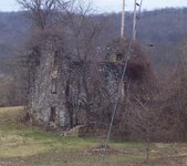
There is an old building that I can see from the back of my house. I'm not sure if it was an old school, church, or farm house. On the map link, the building is in that group of trees next to Weist School Road. I know who owns it, and it becomes very overgrown in the summer, so I don't think I will have trouble getting the OK to hunt it.
Does anyone have an old map of Oley township that may say what it was? It would be the southwest corner of Moravian School Road and Weist School Road. I've seen pictures of The Moravian School, and I know the locations of the 2 Weist Schools, this is none of them. I'll post pictures a little later today. thanx

http://www.flashearth.com/?lat=40.367409&lon=-75.808412&z=18.6&r=0&src=msl
 

Pic added
 

Attachments

  • bld.JPG
    bld.JPG
    211.7 KB · Views: 541
Although I Can't Quite Be sure

Was Weist School Road,
originally part of Bieber Mill road ?

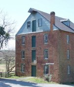
could it be the remains of the Mill ?
 

IF It's a Mill,
there should be a Creek Along side for a water Wheel.

& Possably a Door on the Second Floor

waterford-mill.jpg
 

There is a creek over the hill in the background. It's about 1/2 mile from Bieber Mill Rd. I think I know where Biebeber mill is/ was.
 

mikhen said:
I know for sure it's not Bieber Mill. I just found out that Bieber Mill is for sale.

:thumbsup:

I Have a Friend Checking if he can ID It
as more then just an old Home.

Not sure if this will Show Up
or be a Blur
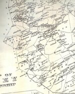
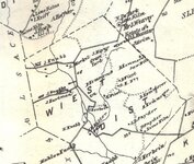
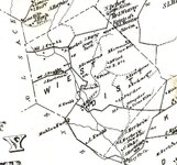
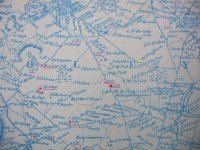
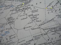
but here is 1876

LastScanw.jpg

LastScanw.jpg

LastScan444.jpg
 

Yellow - i know the 2 farms Kauffman the other Yellow is a Grain Mill

Red - is Sunday Schools Bible Schools Moravian School Grave Yards

............ and a Weist Home maybe you can compare old map to new map ?

black and white - 1876 blue and white - 1862

IMG_9186_2.jpg

IMG_9185_2.jpg
 

I never really compared old maps to new before, this will be fun. I think I know where school house no 7 is. And I see a Moyer listed nearby. The road I live on used to be Moyer Lane. But that means there are 2 graveyards on this map in this immediate area that I don't know about. I know of the 1 so I should be able to go from there. Now I just need a good current map. Thanx.
 

I just ran across this thread and the maps and was wondering if any of you can tell me if the old Jacob and Daniel Wiest homestead survives. I believe it is marked D. Wiest on the 1800 maps.

It was built by Daniel's great grandfather and grandfather (both named Jacob) in the late 1700s and I believe it was a red brick farmhouse with an outlying springhouse.

I think it was still inhabited into the 1900s and I have tried to match up the location on some aerial maps but I don't see anything. Since its in your backyard, could you let me know if anything still stands there today?

Thanks.

Also, what is the history of the Wiest School?

and, I believe there was a private burial plot on the original Wiest property. Any idea if it survives?
 

Sorry for the delayed response. From what I can tell from the maps and looking around back here, it would appear that the Weist School and property are on private property, possibly owned by the quarry.
As far as the building I wanted to search around, I haven't got an answer yet.
 

I believe this place is in my back yard(so to speak). We`ve hiked on the farm land behind our house and found a small house, its not brick, its frame. There are 2 grave sites there. They are both Wiests. They also have those bronze stars there from the milatary? I don`t remember their names. Its been a few years since I`ve been there. The whole bottom of the house is filled with water,clear and cold as can be. (that may be the spring you mentioned)Its pretty well hidden, and I bet the mine owns the land but I have no idea.Its pretty cool and I bet this is what are are looking for.
 

Top Member Reactions

Users who are viewing this thread

Back
Top