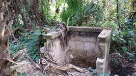
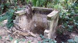
Old Well???

Searchdeep

Jr. Member
Jul 6, 2014
53
102
Orange Park, Florida
Detector(s) used
Minelab CTX3030
Garrett AT Pro
Primary Interest:
All Treasure Hunting
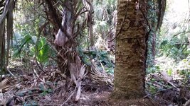
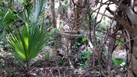
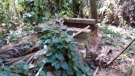
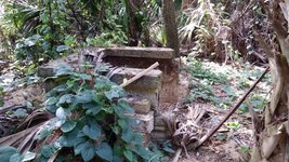
I was out detecting a very old site over the weekend when my wife and I came across this old structure in the middle of the woods. We were a couple of miles from the nearest house. It is made out of coquina coated brick from the Southern Clay Manufacturing Company which is the same brick used to build the streets of St. Augustine. I think it used to be an old well. Anyhow, we are going back to clean the overgrowth from the area so that we can detect it.
 

Attachments

  • image-1113612395.jpg
    image-1113612395.jpg
    118.7 KB · Views: 172
  • image-3855525482.jpg
    image-3855525482.jpg
    115.9 KB · Views: 171
  • image-1614896648.jpg
    image-1614896648.jpg
    110 KB · Views: 180
  • image-3121027849.jpg
    image-3121027849.jpg
    121.4 KB · Views: 171
  • image-1220154297.jpg
    image-1220154297.jpg
    119.9 KB · Views: 161
  • image-3858258911.jpg
    image-3858258911.jpg
    88.3 KB · Views: 151
Upvote 4
Could be the remains of an old liquor still
 

the circular depth of it sure does make it look like a well....
 

I'd clear out the area around it and metal detect it first.
Kind of looks like tabby on top of the brick.. Could be 18 hundreds

Yeah, that is probably what i'll do. See what is around the area first. There should be another structure nearby, but I have not found anything yet.
 

I agree its a water well and not a outhouse just by looking at that top cap of brick. I agree that was the top and went up no further. Two thoughts I had. One it has been dug by someone looking for bottles and relics sometime in the past. I have dug a few wells / outhouses and for safety reason if I was going to dig it I would want to take out one of the walls. Would create a safer way to move in and out instead of trying to climb over a wall. That would explain the bricks stacked up on the side. Second thought was that the wall was removed in order to fill it in after it was no longer in use. Would make it easer to shovel in fill instead of having to lift up over the wall.
 

Try probing inside structure to see how compacted the sand is compared to the surrounding area...

sent from a potato...
 

Try probing inside structure to see how compacted the sand is compared to the surrounding area...

sent from a potato...

I will need to probe this well over the weekend. That is the only time I get a chance to get down there. I will keep you posted.
 

Probably an entire homestead there somewhere I doubt there was just a well in the middle of the woods
 

I saw an app on here to find out who owns what land. It worked for my area (pa). There is a free 7 day trial when you first download it so if you do think of every spot you want to know who owns it before downloading it to get the most out of the trial. It's called onX Hunt. After you download it the display button is a deer rack with the apps name below.
I downloaded it. Unfortunately it doesn't support Maine, the state I live in full time. To bad ad it looked like a cool app...

sent from a potato...
 

If you're looking for property ownership and boundaries, why don't you just go to your county tax assessor website? Just about every parish(county) in my state has a direct link to the interactive GIS mapping database for that area.

Here's a snapshot. Zoom in and out, select the parcel you're interested in with your mouse and the public data is displayed. Often the Property Mailing Address is a PO Box (which doesn't help much), but by doing a little investigating you can usually track it down to a person, family, business or trust entity. If nothing else you get general boundaries. Good Luck!

OK, got it figured out. Just click on the picture and it will go full size.


GIS sample.png
 

Last edited:
Here the taxes are assessed by the local little town. Often the towns website is very primitive. The little town I live in can't even accept debit or credit cards. Lol!

sent from a potato...
 

Here's a pretty cool historical topo website. I use them for finding old schools and other public areas that are long gone, but were always marked on topos.

1) Click on the link below, then click on Step 2 "Map locator & downloader".

2) Double-click and zoom in on the map to get the quadrant you want. Click on "Mark Points" to put a red marker exactly where you want it and then click on the red marker. A list of available topo maps will appear that you can download for free.

3) In the list of maps that appears, under the column "Download" click on the map size you are interested in and it will download a zip file containing a pdf file. Just double-click to open it. They are fairly large files with very good resolution. Some locations go back to the teens and 1920's, others only to the 60's or 70's.

The National Map: Historical Topographic Map Collection -- Download Instructions
Thanks!!!! I'll have a look on the laptop when I get home.

sent from a potato...
 

Top Member Reactions

Users who are viewing this thread

Back
Top