Old Hand Dug Holes Found And What Took Me There

Hello Tinhorn,
there is very likely some useful information the series of dots indicating a trail, the carving on the left hand side looks to be very Spanish, the ? H R ? looks like the rough hewn was done on purpose, the notch on the V lower right hand side should not be discounted either, possible drill hole in the middle. If its easy to get to I would think that a camera with a flash after dark might show more from different angles, That worked on some for me where the carving's were really almost gone, about every 10 degrees or so may work, sometimes a colored filter on the flash. Keep in touch. How's the Kid's & wife and & folk's doing.
 

Those AMBER eye glasses that you can find at the Dollar Store that's helpful in all kinds of driving conditions, I find that when you place one of the lens over the camera lens it intensifies the carving somewhat. I think you will like it if you have a problem. I wonder if the H cross bar is extended because it indicates TWO mountains or streams, the dot in the center may indicate a league
 

Looking at your post once more, I think I see a 4 inch diamond near the bottom. It could be a renegade Spanish / KGC or outlaw that has knowledge of both. Very interesting. It could be a grave marker that was in some ones yard and served as both information and grave
 

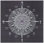
aztec compass_001.jpgcompass_001.jpg
 

Last edited:
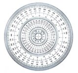
Alabama, the Compass on the left is a Aztec Compass and the Compasses on the right is a selection of compasses ( I think there's five and the one in the center has some thing that verifies that its correct ) Where's Short Stack at.
 

Anyone that's using the Spanish Fort Texas, and the Sacred Heart mission at the west side of Konawa Okla. it was then moved 25 miles to Asher Okla. and North to its New location at Shawnee Okla. Either site will get you there This should put someone in the center of a 25 mile Square Township which should have an old religious Church There's more information on the lay out of what seems to be the method that was used. There should be a vault and perhaps a Royal Trail for( I ) think was used for tools and such for settler's supply needs near by, my thoughts are that they the northeast corner section for the supply depot. My thought's are that if you can find the center location ( Church ) then it will be a lot easier to go from Church location to Church location and locate the N.E. corner of each or you can locate the N.E. corner of a settler's section which is usually the most interesting. To me ITS all interesting, I like the Site's that Twisted Fork worked and DTTH has worked out, I'm sure that there's others also. Something that I find Interesting is the State of Oklahoma was preserved for Indian Land, It seems that from the East Arkansas border to the West Oklahoma border ( Texas Line ) ( and if memory serves me right its 120 Leagues wide ) All of the Distances match, scale border to border, The Spanish that Measured it in 1840, The U.S. Government that measured it for the allotment, and the present is the same. I Believe my memory is that its 300 miles. I'll check it later.
 

Everything on the compass's is used for a purpose, nothing there is to trick or confuse, Time / Distance / Direction, are all there for a purpose
 

Dsty,
i was thinking about some of these square shapes that appear, some are carved into rock, some are square rocks, some are shadow signs, but i'm wondering if they may be corner markers for a square pattern. The small ones i mean, say a foot or smaller?
 

Hello Tinhorn, I would think that if its a 12" X 12" square either a rock or carved in a boulder and the ones that I have seen seem to be the near the center of the rectangle / triangle / square, really look good for corner markers in the degrees as if was in the center, X or a Y and it should work out pretty close. Still have not had a chance to get a Topo for down south. Tell the folks and family I said hello
 

I found this while looking for the Settlers Square League that I posted, This REALLY brings back some fantastic memories, From the Start to The old hand dug hole. The Lessons learned will last a life time, This was in the NE corner of a Settles Square League, information was it was 7ft 7inches deep ( verified by the depth of the hole what was 7' 7" deep and was 7 7 foot across, dirt was in a mound around the top of the hole. I believe all of the square leagues had the same information and it was 112 bars that was 455 grams each.
 

D.T T.H Did you find this information helpful,

Yep, I sure do Dsty. When i cant make it up in the mountains any more, iam gonna search the foot hills and flats for these layouts,and use your thoughts. I believe your right about them leaving caches at certain places to help the Priest start new settelments in the area.
 

Well folks if you can find an old small church or a place of worship which may indicate the center of a settlers square league the look at page 3 / 4 just kinda have to do a lot of walking looking for the 4 corners that will be marked, they will show at least two corners and as many as 4, a river or some other barrier will indicate, Baren land on the other side will be surveyed but will not have as much information in the NE corner such as just initals which you change from letters to mumbers to get the section # such as HJ = 810, I wish I had another life time to figger it all out, take care
 

Is anyone still visiting this one? I had a good one to explain about 6 Indian silver mines in Kentucky and the directions to them...took a long time to cypher it out...but you had to put your mind into Indian gear. Not use todays thoughts.
 

Hello Curtis, seems that everything never remains the same, one of the hardest thing to do is to figure what type of trail you are on, are the trails to the mines marked in the Spanish manner, or just Indian, such as feathers, bow and arrow, Is there a River / Stream flowing down a Canyon. I( would be interested is seeing a couple if you could post them. Thanks
 

Well Here I am in Amarillo, really enjoy it but sure miss home, been here since December. I worked five cache sites where settlers had their stuff. The most important thing is to remember when you find sign there will be something inside the North West Corner that will tell you what to look for, Square, Rectangle, Triangle. Look for the East side for a EXACT MAP of your interest will be. The symbols will be portions of a Cordel 95 feet = 1/2 use 3/4 of a cordel 1 + +cordel ' they will add the measurements also, If anyone is interested I will try and get a pattern worked out and see if someone at the library will post it, or someone out there will do it
 

Last edited:
This is another site that that has stuff that I personally walked / measured and got a lot of info from an found to true
 

Hello Loot, I went back and found where I posted thing's that I have already went thru and have it posted on page 24 I think, nope it came up page 22
 

Last edited:

Top Member Reactions

Users who are viewing this thread

Back
Top