\
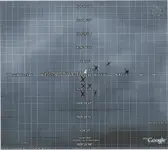
I see a Marquesas Rock in the SE part of the map. I wonder if this is the reef that the ship wrecked on or is it somewhere else? The topo shows a curve to the SW where deep waters and reefs meet.
Atocha coordinates should be about in the SW corner of sect 432. Here is the zoomed in map. I don’t see any 55 feet water areas, just is rather shallow.
All the safe deep water is to the SW of Marquesas Rock.
Sect 478 is where I found a drift trail East of Atocha chords, just above Marquesas Rock. Also found a SE trail in about the where sect 565/566 meet, SW of Marquesas Rock.
The place where the Atocha hull had sunk, according to the info from the references below, was in the deep water of a 55 foot depth. It seems the public records place the coordinates in the center of the sand bar.
The Mel Fisher site mentions Columbian emeralds, silver and gold artifacts recovered from the Atocha.
http://www.melfisher.com/default.asp
A wave lifted the Atocha from being anchored and brought it down on the reef breaking a hole in the hull.
“With crew and passengers huddled, praying below deck, the Atocha approached the line of reefs dividing safe, deep water from certain death. The frenzied crew dropped anchors into the reef face, hoping to hold the groaning, creaking galleon off the jagged coral. A wave lifted the ship, and, in the next instant, flung it down directly onto the reef. The main mast snapped as the huge seas washed Atocha off the reef and beyond, trailing her broken mast. Water poured through a gaping hole in the bow, quickly filling the hull with water. The great ship slipped beneath the surface, finding bottom 55 feet below; only the stump of the mizzenmast broke the waves.“
The Atocha story is told on this page.
http://www.melfisher.com/Library/AtochaMargStory.asp
According to Wikipedia a second hurricane hit in October of the same year which made salvaging the Atocha very difficult. The missing stern castle would hold most of the gold and rare Muzo emeralds.
“The Atocha had sunk in approximately 55 feet of water, making it difficult for divers to retrieve any of the cargo or guns from the ship. A second hurricane in October of that year made attempts at salvage even more difficult by scattering the wreckage of the ship still further.”
http://en.wikipedia.org/wiki/Nuestra_Señora_de_Atocha
I first tried using Xs to find the drift trails. As you can see it looked like a mess. Here is the NW corner. The drift trails are obvious, but stuff seems to be too scattered.
So, I had to do something different. After one X in a location would try to dowse the edges of a trail, working out from that spot. It makes more sense and worked better. The trails were filled in with white grease pencil to make them more visible. I’ve added the extended maps also. A couple places the trails went over the edge.
You can see the original map mess with Xs, follows the second dowsing quite closely, even has similar void areas. When I first started the Xs were much to large, making it too hard to find the drift trails.