new show on the dutchman

I don't agree. I think there is already substantial evidence that Bigfeet (Bigfoots) exist. Thousands of tracks, a crapton of hair samples that when matched against ................. ANIMAL HAIR DATABASES ....................... <cut>
Mike

Mike: Databases!!! Ha ha - good one. In this case, I'm in the database camp. Ha ha.

Harleyman: a number of armed witnesses have been unable to pull the trigger because they were not certain that the creature wasn't some type of human - Neanderthal maybe. If you look at the forensic crime artist's many drawings from witness interviews on the Hoopa Reservation (The Hoopa Project), where sightings are common, you'll see what they're seeing.
 

Joe,

That's what happens when you drop 500 pounds of dried corn in your back yard!:laughing7:

Mike

Mike,

Nop, these boys were just going by at a fast pace......no time to nibble.:happysmiley: After trailing them for a few miles, they stopped for dinner:
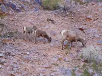


There were around twenty of them in the bachelor party.

Take care,

Joe
 

So it looks like they are going to climb up a ladder.

In the clues I've read, it sounds more like you would ultimately climb down instead of up. Also, if the clues were from Waltz with the intention of helping someone to find the mine, climbing up a ladder seems like a pretty useful clue to omit.

Or am I wrong?

As I've said, I'm not a LDM hunter so maybe I am missing some of the clues or reading them wrong

Thoughts? Thanks!
 

Last edited:
So it looks like they are going to climb up a ladder.

In the clues I've read, it sounds more like you would ultimately climb down instead of up. Also, if the clues were from Waltz with the intention of helping someone to find the mine, climbing up a ladder seems like a pretty useful clue to omit.

Or am I wrong?

As I've said, I'm not a LDM hunter so maybe I am missing some of the clues or reading them wrong

Thoughts? Thanks!

I think walzs said you had to climb up in order to climb down to the mine. Somthing to that effect.
 

Just a nice round number used in the show CN.
You can crunch the numbers if you want, but it's based on Waltz having "guesstimated" that his mine contained enough gold to make 20 men millionaires.
That was back when Gold was valued at about $20.00/oz. Today it was $1,153.38.....down $8.27 for the day.

Hardly worth packin it out....:laughing7:

Well maybe in Canuook money, but the current value of a million ounces is on the order of a billion USD. And ... the million ounces has never been substantiated anywhere. Perhaps you would like to do that for us now?
 

Well maybe in Canuook money, but the current value of a million ounces is on the order of a billion USD. And ... the million ounces has never been substantiated anywhere. Perhaps you would like to do that for us now?

Well yeah it has, There enough gold in site to make 20 men millionaires. At twenty dollars a oz.
It would take one million oz, duh'

Wrmickel1
 

No wonder why waltz farmed chickens.
 

Question for a the group. Doing some research I found some info that was interesting. In the old days all the mountains around the Phoenix area were called the Sups. This included the McDowell range going north up past Pinnacle Peak. Ft Mcdowell to the Indian settlements going north along the Palo Verde was a military trail that was the major trails of the day. I read an account that a rich mine is located north and east of carefree. Some of you might have read the story but I can not find any discussions related to it. The story goes that the Palo Verde and Pinnacle Peak are the land marks. Weavers needle can be seen at 4 O'clock about 60 to 80 miles to the south. This story got my interested because I have 4 wheeled a bit in that area and there is lots of rose quartz there. They actually is and small hill call quartz mountain and it is solid rose quartz. I can't find it on a map but it showed on my GPS in the Jeep. We actually had taken a wrong trail and stumbled upon it. A trail goes right to the top and A big chunck of that hill has been mine out or blasted out facing south. The rose quartz was great looking and I always have wanted to go make with a sledge, chisel and pry bars and get me some big rocks for the yard. This was before I got interested in the LDM but now I want to go back and probe that area a bit more and take a closer look at that rose quartz hill. Could the mine actually be up north and everyone has been searching the current sups and not was once considered the sups. Interested to hear everyone's thoughts. I think I will take my rock hammer and Jeep and do a little searching today as this pretty close to home.
 

Question for a the group. Doing some research I found some info that was interesting. In the old days all the mountains around the Phoenix area were called the Sups. This included the McDowell range going north up past Pinnacle Peak. Ft Mcdowell to the Indian settlements going north along the Palo Verde was a military trail that was the major trails of the day. I read an account that a rich mine is located north and east of carefree. Some of you might have read the story but I can not find any discussions related to it. The story goes that the Palo Verde and Pinnacle Peak are the land marks. Weavers needle can be seen at 4 O'clock about 60 to 80 miles to the south. This story got my interested because I have 4 wheeled a bit in that area and there is lots of rose quartz there. They actually is and small hill call quartz mountain and it is solid rose quartz. I can't find it on a map but it showed on my GPS in the Jeep. We actually had taken a wrong trail and stumbled upon it. A trail goes right to the top and A big chunck of that hill has been mine out or blasted out facing south. The rose quartz was great looking and I always have wanted to go make with a sledge, chisel and pry bars and get me some big rocks for the yard. This was before I got interested in the LDM but now I want to go back and probe that area a bit more and take a closer look at that rose quartz hill. Could the mine actually be up north and everyone has been searching the current sups and not was once considered the sups. Interested to hear everyone's thoughts. I think I will take my rock hammer and Jeep and do a little searching today as this pretty close to home.

Duppa was exploring that area I think?
 

Question for a the group. Doing some research I found some info that was interesting. In the old days all the mountains around the Phoenix area were called the Sups. This included the McDowell range going north up past Pinnacle Peak. Ft Mcdowell to the Indian settlements going north along the Palo Verde was a military trail that was the major trails of the day. I read an account that a rich mine is located north and east of carefree. Some of you might have read the story but I can not find any discussions related to it. The story goes that the Palo Verde and Pinnacle Peak are the land marks. Weavers needle can be seen at 4 O'clock about 60 to 80 miles to the south. This story got my interested because I have 4 wheeled a bit in that area and there is lots of rose quartz there. They actually is and small hill call quartz mountain and it is solid rose quartz. I can't find it on a map but it showed on my GPS in the Jeep. We actually had taken a wrong trail and stumbled upon it. A trail goes right to the top and A big chunck of that hill has been mine out or blasted out facing south. The rose quartz was great looking and I always have wanted to go make with a sledge, chisel and pry bars and get me some big rocks for the yard. This was before I got interested in the LDM but now I want to go back and probe that area a bit more and take a closer look at that rose quartz hill. Could the mine actually be up north and everyone has been searching the current sups and not was once considered the sups. Interested to hear everyone's thoughts. I think I will take my rock hammer and Jeep and do a little searching today as this pretty close to home.

Many people have come to the same conclusion that you did. People have worked above the salt,and some have gone almost to globe ,and others are in other areas. The usgs map that broke up the mountain into different ranges is believed to be one reason why it hasn't been found. People would buy a map,and go to the superstition mtn. Not realising that waltzs sups were much bigger play ground.
I personally doubt his mine is up north based on little side stories.
 

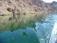
Went boating on the Colorado River in Black Canyon below the Hoover dam and made a few friends!
image.jpg
image.jpg
 

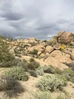
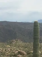
Had a good day poking around yesterday. Found the quartz outcropping I was looking for. Seems to be very extensive in the area. I could follow it up the ridge to for at least a mile. Where ever the top soil got thin the quartz was exposed and eroding away. Looked like a good area to me but what to I know, lol. White and rose quartz that is iron stained and evidence of copper everywhere too. Have some nice quartz samples and one sample with lots of copper in it and lots of tiny sparkle . Saw lots of stacked rock markers too. One picture I took I could see 4 different markers. Walked a couple of miles and it was hot. Close to 90. Rain from a couple of weeks ago has everything blooming and my nose didn't like it. Lots of that white powdery cement like stuff around too "cliche". The biggest outcropping had been worked hard in the past. Half of it was gone. I am talking hundreds of tons of material at least 30 feet high facing south. I am sure someone blasted it out. The north side is still buried under top soil but I bet the area has promise but not for my skill level and it is to close to the ATV crowds also lots of heli's both private and feds flying around. 2015-03-12 14.49.27.jpg2015-03-12 14.57.08.jpg


How many stacked markers do you see in the picture. Second picture shows the tip of weavers needle in the distance
 

Here's the Petroglyph from the Massacre site at Montezuma's head Sierra Estrella Mountains. You can no longer go there roads are all blocked. Looks like an Infinity Treasure Map. Ladder symbol is a mosaic. Almost like the pattern on a Rattler!


View attachment 1130528
 

Here's the Petroglyph from the Massacre site at Montezuma's head Sierra Estrella Mountains. You can no longer go there roads are all blocked. Looks like an Infinity Treasure Map. Ladder symbol is a mosaic. Almost like the pattern on a Rattler!


View attachment 1130528

Nah, it's a Chinese handcuff.

bush_chinese_handcuffs.jpg

I also see a 45rpm turntable spindle adapter on that panel. Guess my pareiodolia has gotten out of control.
45.jpeg
 

Quick ?: was the "Willow Canyon" that Jack took the metal detector guy up to see the ladder glyphs refer to Peralta Canyon?

If so, they didn't have to hike in too far.

George
 

Top Member Reactions

Users who are viewing this thread

Latest Discussions

Back
Top