New permission, old cemetery. How would you approach this area?

TrpnBils

Hero Member
Jan 2, 2005
870
1,234
Western PA
🥇 Banner finds
1
🏆 Honorable Mentions:
1
Detector(s) used
CTX 3030
Primary Interest:
Metal Detecting
I am not asking about hunting the cemetery. I am asking about how to interpret a potential home site or recreation site in which a cemetery happens to be the only thing left.

Got permission at a site yesterday that might hold some promise. A coworker told me about an area on some property he has been deer hunting for the past 25 years and got me in touch with the owner. Basically it's an old, Civil War era cemetery with about ten or twelve marked graves in the middle of the woods on top of a hill not near anything. There's a small dirt access road that goes in the general vicinity of this cemetery, but it's not like it goes TO it, meaning I think it was added later on after the cemetery was forgotten. I haven't been there yet, but I get the impression that it may have been a family cemetery because of the size and because I don't think there was ever a church anywhere nearby.

How far away would any houses likely have been? There is an 1885 house on the property but it's a good half mile away, and the cemetery predates it by a bit. I THINK there may have been a previous house adjacent to the one that's there, but again, it's half a mile away, which makes me wonder if there's another site I haven't found yet.
 

Last edited:
Upvote 0
did you check for historical aerials of the area ?
Perhaps the other home was still standing in the Late 30's when
Aerial Photographs were going on here in PA.
And perhaps that they were going on there Too

http://wvgis.wvu.edu/data/otherdocs/wv_historical_geospatial_products.pdf

I have - the earliest they go back here is 1943 and it doesn't look like anything is there to me, but it's also really grainy at any level of zoom that might be useful. EarthExplorer usually has clearer images than HistoricAerials.com does, so I will give that a shot later. I'm mainly looking for homestead "areas" rather than actual houses at those levels of zoom.
 

Something else that might help would be a topographical map of the area. I believe that the USGS used to put these out and I have some for the Shenandoah Valley area and up toward the mountains near Sugar Grove WV. There are the indications of structures on those depending on how old they are and when they were last updated. It also helps with the contours of the land and roads and trails, etc. worth checking.
 

I'm fortunate to live on our ancestral farm.

My great grandparents are in the family cemetery about 1/4 mile away from the homestead up on the West ridge above the house. Their ancestors are on another ridge to the West about a mile from me.

I guess it really varies, particularly given some folks placed the cemeteries much closer to their homes. It seems in this area that they liked putting them up on ridges - Closer to their eventual homes in the sky.

Yours is on a hill. I'd be looking first around the base of the hill in a flatter area for the homestead.
 

Yours is on a hill. I'd be looking first around the base of the hill in a flatter area for the homestead.

I wondered about this, but the field at the base of that hill is in a flood plain which makes me think it might not have been there. Just going to need boots on the ground to verify.
 

I wondered about this, but the field at the base of that hill is in a flood plain which makes me think it might not have been there. Just going to need boots on the ground to verify.

We've had torrential rains here again. We can't get out right now because the creek is up about a foot over the bridge. And, the branch below the house is up over the sides as well. My folks were very aware of the flood plain, and put their homes on the East slope about probably 15 feet in elevation above that branch.

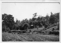
Farm before my house built.jpg
Picture of Great Grandparents home taken in the late 30's or early 40's. You get an idea of the lay of the land - might help.

IMAGE0007.JPG
Me in front of that home in about 1951.
 

Last edited:
We've had torrential rains here again. We can't get out right now because the creek is up about a foot over the bridge. And, the branch below the house is up over the sides as well. My folks were very aware of the flood plain, and put their homes on the East slope about probably 15 feet in elevation above that branch.

View attachment 1443948
Picture of Great Grandparents home taken in the late 30's or early 40's. You get an idea of the lay of the land - might help.

View attachment 1443949
Me in front of that home in about 1951.

That was one of two reasons our family plots where on the west end of the ranch, it was the highest point away from the water, south Texas gets some nice mean floods and people often sort of wash up. But also because it was so far from most game trails. We would hunt off the porch, no sense in doing that city boy hunting in a blind.

Point being is there are some good reasons and some very odd reasons people pick their plots.

This place I would start my looking up the hill, not even an MD hunt, just a walk through looking for anything that stands out from foundation blocks or just trash.

Now an atv trail was mentioned for hunter access. Our small ranch, the 28,000 acre ranch that sits right in the middle of the old Moon Light Cattle Drive trail has been in our families name since we migrated to the US back in the early 1800s. We have trails all over it that have been used for a very long time.

Point is we are humans, its like tracking a human, we are lazy and generally worthless in the bush and sure are not going to cut a new track through no bush if we can use something that already exist, even if it is a hint of an old game trail, who knows maybe that trail before it was game was some access trail for a wagon.

Just saying, we are all pretty darn lazy, I would check that trail too, should not take long if it is only that wide, but you should be able to get pointed in a proper direction based on trash concentrations and the age of the trash.
 

I would imagine that the size of the property would dictate how far away a cemetery would be away from a house. If you only owned 5 acres, you couldn't put your family plot very far away. Knowing who owned the land back when the cemetery was built, and how big their homestead was, would be where I would start. County tax records might help in that respect.
 

I would imagine that the size of the property would dictate how far away a cemetery would be away from a house. If you only owned 5 acres, you couldn't put your family plot very far away. Knowing who owned the land back when the cemetery was built, and how big their homestead was, would be where I would start. County tax records might help in that respect.

I agree - the current property is 146 acres, but I have no idea what it would have been in the 1860s, which are the dates on the head stones.
 

I would concentrate on water sources in the area. The house would more than likely be near a reliable water source.

HH, RN
 

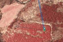
Maybe check that untouched stand of trees before the water down and off to the right of the upper mark if it levels out any in that area.

Many of the burial plots around here seem to be in the best place to overlook the house. Maybe take a walk up there and see what you're overlooking from that perspective.
 

Capture02.jpg

On enlarging it, that area looks too steep...this would be my guess.

Good luck.
 

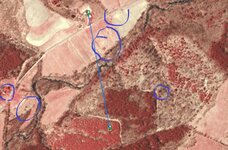
From the looks of the aerial shot you have, looks like the water is there in form of creek or river, looks like there are other trails/roads in the same area that run along that same ridge. Also on the side with the cemetery, where the fields are, looks like a row of trees running to the lower right corner of the picture that could be a property line or field break. Also near the line, just to the lower left, there is a semi-circle of trees (looks like it to me) that might have been near to a house once, maybe. Looks like you have a lot of places to check and several here are seeing a lot of "Hot" spots. Good Luck!
 

Well now I guess there is only one thing left to do, post it in that forum where people look at pictures and tell you what you have and where it is. I forget what they call that stuff and have no idea if or how it works, but it would be cool if someone there pointed you to some nice buried silver.
 

From the looks of the aerial shot you have, looks like the water is there in form of creek or river, looks like there are other trails/roads in the same area that run along that same ridge. Also on the side with the cemetery, where the fields are, looks like a row of trees running to the lower right corner of the picture that could be a property line or field break. Also near the line, just to the lower left, there is a semi-circle of trees (looks like it to me) that might have been near to a house once, maybe. Looks like you have a lot of places to check and several here are seeing a lot of "Hot" spots. Good Luck!
 

though I'm sure You know More about these.

Just a few things that Caught my Eye

Capture.JPG

there are a few others but these were my first catches
 

Last edited:
I'll preface this with; I'm pretty useless with stuff like this (born and raised as a city boy), so country cemeteries are Greek to me.

This may be obvious, but I'd start walking in the direction the headstones are facing. I would imagine they would have faced the homestead? Or possibly away from it? See how much I know? I just think the headstones would face the family. (shrug)

In any case, if I had essentially unlimited MD'ing access, I'd just work it until my arm fell off.
I was told by an older gentleman awhile back that most cemetery's, expecially older ones would always bury you facing East. Christians believe that during the resurrection Christ will come from the East. I've payed attention to this and so far haven't seen one that faced any other way. The cemetery itself may face in a different direction, but the head stones all face East.

HH, RN
 

View attachment 1443991

On enlarging it, that area looks too steep...this would be my guess.

Good luck.


Interesting that you mention that area because on the 1947 aerial photo that point is the only place I can see that looks like it MIGHT have been something of a structure at one point. I'd guess it wasn't unless it was already torn down and messed up by then, but it's the only thing I saw that came close aside from the houses that are still there but not old enough.

From the looks of the aerial shot you have, looks like the water is there in form of creek or river, looks like there are other trails/roads in the same area that run along that same ridge. Also on the side with the cemetery, where the fields are, looks like a row of trees running to the lower right corner of the picture that could be a property line or field break. Also near the line, just to the lower left, there is a semi-circle of trees (looks like it to me) that might have been near to a house once, maybe. Looks like you have a lot of places to check and several here are seeing a lot of "Hot" spots. Good Luck!

You are correct about the property line. The cemetery is up in the corner of the lot and what you're looking at there is the line.

I was told by an older gentleman awhile back that most cemetery's, expecially older ones would always bury you facing East. Christians believe that during the resurrection Christ will come from the East. I've payed attention to this and so far haven't seen one that faced any other way. The cemetery itself may face in a different direction, but the head stones all face East.

HH, RN

This is interesting - haven't heard this before, but it may be something to keep in mind. Even our big cemetery near my house (which is on a fairly steep west-facing hill) has the stones all facing uphill (east) which I thought was odd.
 

Around the border's is fine I wouldn't go few hundred feet. No point... Got not disrespecting nobody by hunting around the border's just not inside
 

TrpnBils, looks like you've got a lot to go on. I agree with KirkS and swing 'till my arm dropped. Good Luck!:icon_thumright:
 

Top Member Reactions

Users who are viewing this thread

Latest Discussions

Back
Top