You are using an out of date browser. It may not display this or other websites correctly.
You should upgrade or use an alternative browser.
You should upgrade or use an alternative browser.
New Gps tracking app for the metal detectorist.
- Thread starter Wormslayer
- Start date
Wormslayer
Jr. Member
- Joined
- Mar 2, 2012
- Messages
- 73
- Reaction score
- 15
- Golden Thread
- 0
- Detector(s) used
- E-Trac, Garrett Pro pointer, Tect O Trak
- Primary Interest:
- Metal Detecting
- #62
Thread Owner
About every 10ft
Last edited:
AzViper
Bronze Member
- Joined
- Sep 30, 2012
- Messages
- 2,038
- Reaction score
- 2,251
- Golden Thread
- 0
- Detector(s) used
- Fisher Gold Bug Pro, Nokta FORS Gold, Garrett ATX, Sun Ray Gold Pro Headphones, Royal Pick, Etc.
- Primary Interest:
- Prospecting
When I first installed the software I was apprehensive that the software was going to work in Airplane mode on my cellphone. Where I metal detect I have no cellphone connection. The nearest tower is a good 6 miles by birds-eye and it’s an A&TT/Verizon tower.
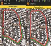
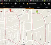
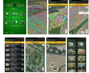
I set out to chart my walk through my sister’s neighborhood using the Tect O Trac and Goggles My Tracks. Below are four images. The first image on the left is with cellphone service on and the right image is with the cellphone in Airplane mode. The next set of images are that of Googles My Track. The images again are with and without cellphone service.
To my amazement both software’s did as they are designed to do. The most important is to track my movement with no cell phone service. Will the software replace my stand alone GPS, no. Being outdoors I need a fighting chance to be able to make an emergency cellphone call if needed. For the relic hunters that are working parks, school yards, etc. the software I give a thumbs up. Even for the gold hunters working outback and has the ability to charge their cellphone I give the software a thumbs up.
When you’re in a wide open space having the ability to at least have an idea as to where you have walked is great, but like all GPS’s they all suffer from pinpoint accuracy and the end user needs to take this in account while using any GPS.
Last edited:
christo000
Silver Member
- Joined
- Mar 17, 2013
- Messages
- 3,765
- Reaction score
- 812
- Golden Thread
- 0
- Location
- mass North Attleboro
- Detector(s) used
- Xp Deus,m-6 pinpointer, technetics t2ltd (had, whites v3i,minelab xterra 705,atpro,prism 4,sunray probe minlabe profind,garret propointer, f75ltd and many more)
- Primary Interest:
- All Treasure Hunting
& that's why I said I use it & have had it for quite a while now cuz it does track where u were & you can see where you havent gone
silverstreaker
Tenderfoot
- Joined
- Jun 18, 2014
- Messages
- 5
- Reaction score
- 3
- Golden Thread
- 0
- Location
- Treasure Coast, FL
- Detector(s) used
- Tesoro Sand Shark
- Primary Interest:
- All Treasure Hunting
Just downloaded the app and will be trying it out this weekend. Looks very nice though

christo000
Silver Member
- Joined
- Mar 17, 2013
- Messages
- 3,765
- Reaction score
- 812
- Golden Thread
- 0
- Location
- mass North Attleboro
- Detector(s) used
- Xp Deus,m-6 pinpointer, technetics t2ltd (had, whites v3i,minelab xterra 705,atpro,prism 4,sunray probe minlabe profind,garret propointer, f75ltd and many more)
- Primary Interest:
- All Treasure Hunting
It does work well especially when u go into larger areas ur not familiar with u just drop ur points down it square s off then hit go ur off it'll let u know where u were what u didn't do to
Jalmar
Tenderfoot
Great work! Im using the lastest version of the app with a Galaxy S4 (Android 4.4.2)
There seem to be a problem with the timestamps. At 14:12 it gives me 02:12. It seems to default to an AM/PM mode, but withouth the AM/PM label? An optional 24h mode would be preferable.
It seems i'm not able to edit the borders of a search area once it's finalized. This functionality should be looked in to.
For future development i would recommend implementing customizable categories for the finds. And the posibillity to hide/show specific categories of items on the map, as well as in the find list.
Wormslayer
Jr. Member
- Joined
- Mar 2, 2012
- Messages
- 73
- Reaction score
- 15
- Golden Thread
- 0
- Detector(s) used
- E-Trac, Garrett Pro pointer, Tect O Trak
- Primary Interest:
- Metal Detecting
- #68
Thread Owner
Thx Jalmar.
Oops! the date/time stamp.. I had noticed but i'd forgotten all about it.. Thanks for reminding me. It will be corrected in the next update.
Quote "It seems i'm not able to edit the borders of a search area once it's finalized. This functionality should be looked in to.
I'm not quite sure what you mean? Why would you want to edit the borders (search area) After finalizing? You have plenty of opportunity to plan and fine tune your search area before you finalize and save. Unless, its just to correct a user error?
Thanks for the idea about hiding/showing categories. Just to take it further.. If the find list image is viewed in a category, (as opposed to being viewed in the general finds list) then it will only show other images from the same category when scrolling through the gallery. Cool! I'll do that!
HH..
Oops! the date/time stamp.. I had noticed but i'd forgotten all about it.. Thanks for reminding me. It will be corrected in the next update.
Quote "It seems i'm not able to edit the borders of a search area once it's finalized. This functionality should be looked in to.
I'm not quite sure what you mean? Why would you want to edit the borders (search area) After finalizing? You have plenty of opportunity to plan and fine tune your search area before you finalize and save. Unless, its just to correct a user error?
Thanks for the idea about hiding/showing categories.

HH..
CWnut
Hero Member
- Joined
- May 9, 2003
- Messages
- 591
- Reaction score
- 37
- Golden Thread
- 0
- Location
- E. Tennessee
- Detector(s) used
- Tesoro tigershark----Tesoro Conquistador Umax------Fisher FX-3----Master Hunter CX-Plus w/ depth multiplier
- Primary Interest:
- All Treasure Hunting
just installed the demo version..i'm thinking i might integrate it as a search and rescue tool....will try it out and get back with my thoughts
Wormslayer
Jr. Member
- Joined
- Mar 2, 2012
- Messages
- 73
- Reaction score
- 15
- Golden Thread
- 0
- Detector(s) used
- E-Trac, Garrett Pro pointer, Tect O Trak
- Primary Interest:
- Metal Detecting
- #70
Thread Owner
Thanks CW
I have just added a compass bearing tool which you might also find useful.
Find out more here:- Tect O Trak - HistoryHunters.co.uk
I have just added a compass bearing tool which you might also find useful.


Find out more here:- Tect O Trak - HistoryHunters.co.uk
MD'erStEvO
Full Member
- Joined
- Feb 16, 2015
- Messages
- 150
- Reaction score
- 170
- Golden Thread
- 0
- Location
- Vicenza (Military)
- Detector(s) used
- XP Deus V3.2 11" Coil, Bounty Hunter Platinum Edition, Garrett Pro-Pointer
- Primary Interest:
- Metal Detecting
Wormslayer,
Congrats on the app.... Do you have it for iPhone ?
?
Congrats on the app.... Do you have it for iPhone
 ?
?Wormslayer
Jr. Member
- Joined
- Mar 2, 2012
- Messages
- 73
- Reaction score
- 15
- Golden Thread
- 0
- Detector(s) used
- E-Trac, Garrett Pro pointer, Tect O Trak
- Primary Interest:
- Metal Detecting
- #72
Thread Owner
Thanks Stevo.
Sorry, no iPhone version yet, but this might interest you..
There is a facebook action group dedicated to getting Tect O Trak onto the iOS platform.
https://www.facebook.com/groups/1569584126596648/
I have copied the text below from the group message board which explains the current situation ~ ( and saves me a lot a typing)
'Unfortunately, due to the specialist nature of our hobby, user numbers are too low to make it an economically viable project. However, I will make it if I can guarantee to cover the development cost. Although I designed and developed the app myself, I am not the actual coder. The hard coding is done by a bachelor of computer science, and he doesn't come cheap! The aim of this group is to collect together 400 users who ( when the time comes) would be willing to pledge £3/$5 in a crowd funding drive facilitated on kickstarter.com. When we have 500 group members, (some are bound to drop out.. ) I will launch the project.
All backers will get a complete and fully functional copy of Tect O Trak for iOS.
I hope you will join us.
HH & Good Luck.
Sorry, no iPhone version yet, but this might interest you..
There is a facebook action group dedicated to getting Tect O Trak onto the iOS platform.
https://www.facebook.com/groups/1569584126596648/
I have copied the text below from the group message board which explains the current situation ~ ( and saves me a lot a typing)

'Unfortunately, due to the specialist nature of our hobby, user numbers are too low to make it an economically viable project. However, I will make it if I can guarantee to cover the development cost. Although I designed and developed the app myself, I am not the actual coder. The hard coding is done by a bachelor of computer science, and he doesn't come cheap! The aim of this group is to collect together 400 users who ( when the time comes) would be willing to pledge £3/$5 in a crowd funding drive facilitated on kickstarter.com. When we have 500 group members, (some are bound to drop out.. ) I will launch the project.
All backers will get a complete and fully functional copy of Tect O Trak for iOS.
I hope you will join us.

HH & Good Luck.
Last edited:
Wormslayer
Jr. Member
- Joined
- Mar 2, 2012
- Messages
- 73
- Reaction score
- 15
- Golden Thread
- 0
- Detector(s) used
- E-Trac, Garrett Pro pointer, Tect O Trak
- Primary Interest:
- Metal Detecting
- #73
Thread Owner
Hi,
To update..
I have recently added some cool new features. You can now view your tracks and finds in Google Earth using a new kml creation and export tool, You will this find by clicking the backup/restore icon. This will create a new Kml folder in the main Tect O Trak directory. You will need to copy this folder onto your pc. You can view your records by clicking on any or all of the kml files contained within the folder, or open Google Earth and drag and drop.
---
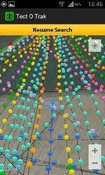
There is also now a new way to view your all your finds at their individual locations all on one map, using the new cluster gallery. There are many ways you can manipulate the gallery, Just have a play!..


Last edited:
Wormslayer
Jr. Member
- Joined
- Mar 2, 2012
- Messages
- 73
- Reaction score
- 15
- Golden Thread
- 0
- Detector(s) used
- E-Trac, Garrett Pro pointer, Tect O Trak
- Primary Interest:
- Metal Detecting
- #74
Thread Owner
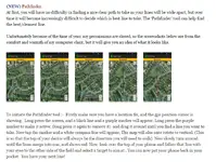
A short clip showing how the 'Pathfinder' tool is used to find your next line.
Harley
Jr. Member
- Joined
- Oct 5, 2004
- Messages
- 25
- Reaction score
- 2
- Golden Thread
- 0
- Location
- Palm Coast, Florida
- Detector(s) used
- Fisher CZ-5, Fisher 1280X,Fisher F-2, Minelab Safari
Ready for the i-phone version.
Wormslayer
Jr. Member
- Joined
- Mar 2, 2012
- Messages
- 73
- Reaction score
- 15
- Golden Thread
- 0
- Detector(s) used
- E-Trac, Garrett Pro pointer, Tect O Trak
- Primary Interest:
- Metal Detecting
- #76
Thread Owner
Wormslayer
Jr. Member
- Joined
- Mar 2, 2012
- Messages
- 73
- Reaction score
- 15
- Golden Thread
- 0
- Detector(s) used
- E-Trac, Garrett Pro pointer, Tect O Trak
- Primary Interest:
- Metal Detecting
- #77
Thread Owner
Tect O Trak. Latest update.
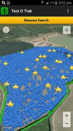
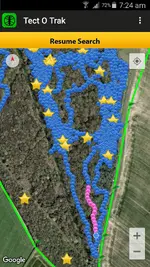
There is now an option to temporarily display all old tracks in a single colour of your choice, while at the same time allowing a high contrasting custom colour selection for the new track. I think you'll agree that it's an improvement and and will have its uses. It definitely makes the 'missed bits' easier to see.
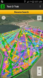
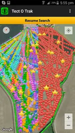
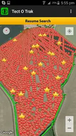
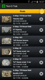
Also, you can now edit your find records titles and descriptions.
Long press the individual find record to activate edit mode.
Also added a user alert if GPS not enabled at start up.
HH
Mark.
There is now an option to temporarily display all old tracks in a single colour of your choice, while at the same time allowing a high contrasting custom colour selection for the new track. I think you'll agree that it's an improvement and and will have its uses. It definitely makes the 'missed bits' easier to see.


Also, you can now edit your find records titles and descriptions.
Long press the individual find record to activate edit mode.

Also added a user alert if GPS not enabled at start up.
HH
Mark.
Last edited:
Wormslayer
Jr. Member
- Joined
- Mar 2, 2012
- Messages
- 73
- Reaction score
- 15
- Golden Thread
- 0
- Detector(s) used
- E-Trac, Garrett Pro pointer, Tect O Trak
- Primary Interest:
- Metal Detecting
- #78
Thread Owner
Tect O Trak update.
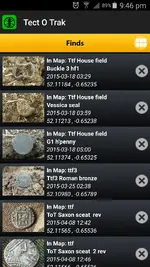
I have just reworked the 'Finds' list. There are now two parts to entering details when recording a find. You now have the option to edit, or add further info. ( ie - after research..) Only the first part which is the the short title, will be visible in the finds list. To view the full title and description, you will need to view the full sized image. Press the ' i ' button top left (full image) to toggle info on/off. To edit, long press the individual record in the finds list.
Also,
The find list image gallery now has auto rotate
The find list thumbnail is slightly bigger.
Replaced the icon used to access the find geo location cluster gallery (Finds list, top right)
For more info about Tect O Trak please visit:
Tect O Trak - HistoryHunters.co.uk
There is a free full functioning version available here
https://play.google.com/store/apps/details?id=com.trib.app.tectotraklite
Or you can 'go pro' and help support further development here..
https://play.google.com/store/apps/details?id=com.trib.app.tectotrak
HH.
Mark.
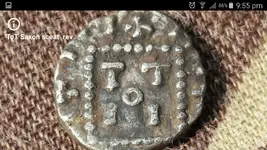


Last edited:
FlightRisk
Jr. Member
- Joined
- Apr 13, 2016
- Messages
- 23
- Reaction score
- 40
- Golden Thread
- 0
- Location
- South Jersey
- Detector(s) used
- Garrett: AT Pro,ACE 250 w/5x8 DD, Pro Prointer
- Primary Interest:
- All Treasure Hunting
I have this app and it works great! I would be interested in the historical map overlays you spoke about earlier in this thread
Wormslayer
Jr. Member
- Joined
- Mar 2, 2012
- Messages
- 73
- Reaction score
- 15
- Golden Thread
- 0
- Detector(s) used
- E-Trac, Garrett Pro pointer, Tect O Trak
- Primary Interest:
- Metal Detecting
- #80
Thread Owner
Thanks Flight,
I will get to map overlays eventually.. That's all I can say at the moment. So much to do, so little time..
I will get to map overlays eventually.. That's all I can say at the moment. So much to do, so little time..

Similar threads
- Replies
- 65
- Views
- 4K
- Replies
- 12
- Views
- 2K
Users who are viewing this thread
Total: 1 (members: 0, guests: 1)


