My abbreviated theory for the Knights Templar treasure in Nova Scotia

A quote I found while researching some of your keywords Loki: "Since Peter-Roger of Mirepoix had been given permission to take all gold and silver with him, what the four intrepid Cathars brought to safety in the caves of the Sabarthes on the lands of the Lords of Castellum Verdurum certainly wasn’t that."

No, it wasn't. When I mention the 160,000 florins of gold the Templar's may have brought to Nova Scotia, it was their own treasure that they had brought from Cyprus. There may have also been some treasures from their Paris headquarters, Temple Villeneuve.
What the Cathar's had saved from the inquisition and later passed on to the Templar's was much more important. It was the same object Otto Rahn mistakenly thought was still within the mountain pog of Montsegur, The Holy Grail.
Cheers, Loki
 

Last edited:
No, it wasn't. When I mention the 160,000 florins of gold the Templar's may have brought to Nova Scotia, it was their own treasure that they had brought from Cyprus. There may have also been some treasures from their Paris headquarters, Temple Villeneuve.
What the Cathar's had saved from the inquisition and later passed on to the Templar's was much more important. It was the same object Otto Rahn mistakenly thought was still within the mountain pog of Montsegur, The Holy Grail.
Cheers, Loki

An interesting little prophecy by the last known Cathar, Guillaume Belibaste, in 1321!
"In 700 years the Laurel will turn green again"
 

Six Years and the Laurel will turn green again......Ok I'll buy that.

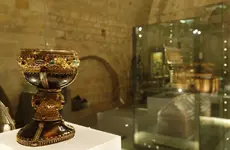
Oh and the Cup that Jesus drank from........was recently given to the public for viewing ...

It is solid onyx and the Spanish Monarch they gave it to keep and hold safe was a friend of the Templars who let the troves rest there until the tomb was built in Rennes Le Chateau and it was left as a gift to him......it was encrusted over with gold and jewels......
Hewn out of Solid Onyx.... slide_343733_3573026_free.jpg
 

Last edited:
The Holy Grail;
from the 1982 publication, Holy Blood Holy Grail, pg. 306:
"In many of the earlier manuscripts the Grail is called the Sangraal,...it is likely that some form-Sangraal or Sangreal-was in fact the original one. It is also likely that that one word was subsequently broken in the wrong place. In other words, 'Sangraal' or 'Sangreal' may not have been intended to divide into 'San Graal' or 'San Greal'-but into 'Sang Raal' or 'Sang Real', Or to employ the modern spelling, Sang Royal. Royal Blood".
The authors continued this line of reasoning with "Its traditional association as the cup that caught Jesus blood... would seem to reinforce this supposition".
In keeping with the Oak Island, Nova Scotia, treasure theme of this section of the Forum, I premise this particular form (mostly in documents, but with a surprise) of the Holy Grail along with other Templar treasures was at one time at New Ross (Charing Cross) Nova Scotia, and moved to the area of Annapolis Basin!
Cheers, Loki
 

If there is any interest I can publish the solution to the famed "Shugborough Code" here (there may be a surprise or two). Interesting to note is that the Ansons of Shugborough, Thomas and his younger brother Admiral George Anson were taught navigation by the very good friend of Issac Newton, William Jones. Jones is considered the father of the symbol "pi" for the relationship of the circumference of a circle to its diameter. He also published "The New Compendium of the Whole Art of Navigation".
Cheers, Loki
 

Last edited:
The Shugborough Monument itself, created in the middle of the 18th century, as most already know, is very similar to the 2nd of Nicolas Poussin's painting of "Shepherds in Arcadia" mentioned in post 7 of this thread. The major differences are that Shugborough is a relief and the scene is basically reversed from Poussin's version. But one outstanding feature common to both is that the figures are mulling over a specific part of the lettering that reads "Et in Arcadia Ego" which can be loosely translated to "Also in Arcadia I". The questionable letter seems to be the "R" in Arcadia with one of the Shepherds in the Poussin pointing directly to it and in the Shugborough he is pointing to the word (albeit with a broken off forefinger) "in" while if the thumb was not also broken off it would be almost completely hiding the letter "R". In both works the theme seems to be that the message is transferred to Acadia from Arcadia. One must also wonder why these two particular digits were broken.

The next clue is the letters "D" and "M" at each end of the coded message below the Shugborough relief. What needs to be taken into perspective here is the navigation backgrounds of both of the Anson brothers and at the same time understand that seconds of a degree of latitude or longitude were hardly used in 18th century navigation. These facts would lead one to the conclusion that the "D" stands for "degrees" while the "M" stands for "minutes" or minutes of a degree. A known degree and minutes of latitude along with a known degree and minutes of longitude would be a certain position on the Earth or the "coordinates" of a location. Without the use of "seconds" it would take 4 numbers to supply these coordinates. It is also important to note that prior to the latter half of the 18th century longitude, the position East or West could not be accurately determined while at sea. Only with the use of an accurate timepiece would this become possible. There can be no doubt that the solution to the Shugborough code is the coordinates of a location, but how to read it and where does it take us? Next chance I get I'll post my own answer IMHO.

Cheers, Loki
 

interesting topic especially with the starting of the new Oak Island special November 10th and I think the reruns start 10/27. Hopefully someone can tell the forum if its for real or like Nessie...a phantom picture.
 

The Shugborough Monument itself, created in the middle of the 18th century, as most already know, is very similar to the 2nd of Nicolas Poussin's painting of "Shepherds in Arcadia" mentioned in post 7 of this thread. The major differences are that Shugborough is a relief and the scene is basically reversed from Poussin's version. But one outstanding feature common to both is that the figures are mulling over a specific part of the lettering that reads "Et in Arcadia Ego" which can be loosely translated to "Also in Arcadia I". The questionable letter seems to be the "R" in Arcadia with one of the Shepherds in the Poussin pointing directly to it and in the Shugborough he is pointing to the word (albeit with a broken off forefinger) "in" while if the thumb was not also broken off it would be almost completely hiding the letter "R". In both works the theme seems to be that the message is transferred to Acadia from Arcadia. One must also wonder why these two particular digits were broken.

The next clue is the letters "D" and "M" at each end of the coded message below the Shugborough relief. What needs to be taken into perspective here is the navigation backgrounds of both of the Anson brothers and at the same time understand that seconds of a degree of latitude or longitude were hardly used in 18th century navigation. These facts would lead one to the conclusion that the "D" stands for "degrees" while the "M" stands for "minutes" or minutes of a degree. A known degree and minutes of latitude along with a known degree and minutes of longitude would be a certain position on the Earth or the "coordinates" of a location. Without the use of "seconds" it would take 4 numbers to supply these coordinates. It is also important to note that prior to the latter half of the 18th century longitude, the position East or West could not be accurately determined while at sea. Only with the use of an accurate timepiece would this become possible. There can be no doubt that the solution to the Shugborough code is the coordinates of a location, but how to read it and where does it take us? Next chance I get I'll post my own answer IMHO.

Cheers, Loki

To make a long story short, the solution for the Shugborough code is the coordinates, 44 degrees 32 minutes north by 63 degrees 43 minutes west, or for Google Earth, 44 32 00n X 63 43 00w. This is a general location evidently for the purpose of narrowing down the location of the searched for object in Acadia to Nova Scotia. But, also note that the latitude of 44 32 00n comes very close to the mouth of the Gold River, and in 1750 longitude would never have been very accurate. If anybody wants to know how I arrived at these figures just ask.

Cheers, Loki
 

Last edited:
To make a long story short, the solution for the Shugborough code is the coordinates, 44 degrees 32 minutes north by 63 degrees 43 minutes west, or for Google Earth, 44 32 00n X 63 43 00w. This is a general location evidently for the purpose of narrowing down the location of the searched for object in Acadia to Nova Scotia. But, also note that the latitude of 44 32 00n comes very close to the mouth of the Gold River, and in 1750 longitude would never have been very accurate. If anybody wants to know how I arrived at these figures just ask.

Cheers, Loki

Hi Loki

My coordinates for the Freemason's Celestial Map are at 44.51.23 and 64.28.92, which is where their Apex Point at the Triangle would have been located.

When I use your coordinates of 44.32 and 63.43 on my Stellarium program it gives a perfect fit for all the cross triangulation leading to both the Treasure Vault and Francis Bacon's Tomb.

What I had not taken into fact was that the "Prime Meridian" has shifted "East" each year.

In 1750 the coordinates you gave would have been the coordinates of Oak Island.

This could explain how these coordinates may have been supplied to the American Freemasons to recover the treasure.

My question is: How did you obtain these coordinates from Admiral Anson's Shugborough Monument?
 

Last edited:
Hi Loki

What I had not taken into fact was that the "Prime Meridian" has shifted "East" each year.


Robot, I do not follow your reasoning here. The Prime Meridian was always determined by men and since the late 18th century has been located at Greenwich, England and it has not moved. Prior to this it was located at Paris, the Canary Islands, West of the Cape Verde Islands (the Tordesillas Line of 1494) and Potolemy's use of the Fortunate Islands in the 2nd century, among a few others along the way. How do you arrive at the conclusion that it has shifted East each year?

Cheers, Loki

Hi Loki

Yes, roughly 350 feet each 100 years

Why the 'Prime Meridian of the World' Shifted Hundreds of Feet

Let me know how your deductions for your coordinates from the monument were derived.

Thanks

Robot
 

Hi Loki

Yes, roughly 350 feet each 100 years

Why the 'Prime Meridian of the World' Shifted Hundreds of Feet

Let me know how your deductions for your coordinates from the monument were derived.

Thanks

Robot


No, some 300 feet because of more accurate measurements, not a certain amount east every 100 years, you may be confusing this with the magnetic North Pole which is steadily moving. Remember, the Prime meridian came first and the worlds grid of longitude followed from that. Now with the grid established by gps systems it was found that the original pm needed to be moved the 300 feet to compensate for a certain error. It also had been moved some 20 feet west because of an error discovered earlier. The longitude I posted is actually 29 miles east of Oak Island, but I also mentioned that at the time accurate longitude readings were very difficult to obtain. Without an accurate timepiece an observer would have to use a known timed event such as a lunar eclipse and also know at exactly which moment during this eclipse to take his readings in order to determine how far he was east or west of a known meridian. All of this would also depend on how accurate the forecast of the timing of the event was from the several months earlier when he left the known meridian.
The coordinates I posted could possibly be referencing Oak Island as 29 miles of error is well within the standards of 1750. I have found as much as 40 miles of error in longitude in 18th century maps of the Acadian areas.

I used the Cub Scouts "letter number cipher",lol, to get the coordinates from the Shugborough Monument. The relief on the monument is reversed from its famous counterpart so you need to start out by reversing the numbers. Did you even notice that both works are telling us that what we are looking for is in Acadia and not Arcadia?
Cheers, Loki
 

Last edited:
No, some 300 feet because of more accurate measurements, not a certain amount east every 100 years, you may be confusing this with the magnetic North Pole which is steadily moving. Remember, the Prime meridian came first and the worlds grid of longitude followed from that. Now with the grid established by gps systems it was found that the original pm needed to be moved the 300 feet to compensate for a certain error. It also had been moved some 20 feet west because of an error discovered earlier. The longitude I posted is actually 29 miles east of Oak Island, but I also mentioned that at the time accurate longitude readings were very difficult to obtain. Without an accurate timepiece an observer would have to use a known timed event such as a lunar eclipse and also know at exactly which moment during this eclipse to take his readings in order to determine how far he was east or west of a known meridian. All of this would also depend on how accurate the forecast of the timing of the event was from the several months earlier when he left the known meridian.
The coordinates I posted could possibly be referencing Oak Island as 29 miles of error is well within the standards of 1750. I have found as much as 40 miles of error in longitude in 18th century maps of the Acadian areas.

I used the Cub Scouts "letter number cipher",lol, to get the coordinates from the Shugborough Monument. The relief on the monument is reversed from its famous counterpart so you need to start out by reversing the numbers. Did you even notice that both works are telling us that what we are looking for is in Acadia and not Arcadia?
Cheers, Loki

You are right this shift is due to inaccurate measurements and not a shift due to the Earth

The Prime Meridian has been corrected several times over the centuries due to inaccurate measurements to where today with modern satellite measurements it is out over 100 meters to the East.

Maybe more info on your Boy Scout Decoder Ring and how you came up with your coordinates?
 

You are right

Maybe more info on your Boy Scout Decoder Ring and how you came up with your coordinates?

A=1, B=2, C=3, O=15, U=21, V=22, S=19, now you have to create 4 numbers from 8,= 36/ 34/ 23/ 44 ( read latitude first from right to left (reversed, as the relief tells us), longitude still reversed but read left number (degrees) first, very simple, yes! D and M, degrees and minutes.

As I mentioned, I have found more than 40 miles of error in longitude readings from 1750 maps, but latitude from a land based observation can be very accurate. I have come within a quarter mile using simply a framing square and level (which is basically all they had in 1750) in an experiment.

Cheers, Loki
 

Last edited:
When I use your coordinates of 44.32 and 63.43 on my Stellarium program it gives a perfect fit for all the cross triangulation leading to both the Treasure Vault and Francis Bacon's Tomb.

In 1750 the coordinates you gave would have been the coordinates of Oak Island.

Robot, the coordinates I gave were for degrees and minutes of a degree, each minute being 1/60th of a degree, but the way you wrote them is in degrees only. For instance a longitude written as 63.43 degrees would actually be 63 and 43 hundredths of a degree, whereas what I had written would be 63 degrees and 43/60th of a degree. This would result in an error of several miles. Just curious about what that does to your cross triangulation?
Cheers, Loki
 

Top Member Reactions

Users who are viewing this thread

Latest Discussions

Back
Top