Mine with the Iron Door The Legend

I just l-o-v-e their GPR - wish I had one of those!! Last time I checked it was the 'box-on-wheels' and it cost a fortune-and-a-half to rent one (deep sigh)

It may not be A GPR.

It could be a Cesium Photon Magnetometer which does not need to have ground contact.

Accurate locators used to make and sell those units. They've gone under and are no longer in business. I had one for a while and they are quite impressive. Unless you have decent target already picked out they can be just as cumbersome as a GPR. When I had mine years ago I wore out the Mag's running them over weeds and other plants. When Accurate attempted to not honor the warranty on the sensors accusing me a dragging the sensors behind a vehicle I argued that it was BS and they needed to send me another set of four. They eventually conceded and sent them. I sold the unit right after discovering they would wear out fairly quickly on the Desert plants in Arizona. I wish now I would have kept it. But since Accurate is no longer in business it would be impossible to get any parts for it. If it is a GPR it must be a powerful signal to be able to penetrate the ground from a foot above.
 

The last episode of the Sacambaya Treasure on Treasure Quest this season has many similarities to the Molina Document and Map. I would say that whomever constructed the t of t waybill did the same with the Sacambaya waybill. They both sound the same in that respect. It seems to follow a pattern of waybills and could be true. If it is than the Tumacacori waybill must also be treasure document. I don't think it to be Jesuit. Just maybe those who reported the Jesuits before the expulsion as being rich are the ones that had the treasures and only wanted to pin the hoarding on the religious priests. The references to "San Ramon" and other similar writing gives one pause to these waybills.

If the Treasure of Sacumbaya is proved to be real I believe the waybill Treasure of Tumacacori could be real as well.
I noticed they mentioned Tumacacori and El Tio in the history of Jesuit Missions.


I can't wait to see the show next week!!

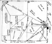
Bill , of course the treasure of Tumacacori is real as its map . Want you something to see about ?

Tmap.jpg

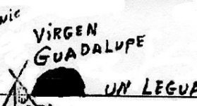
Look at the map and you can see they give a clue of how the region of the Virgen de Guadalupe should looks like .

VdG.jpg

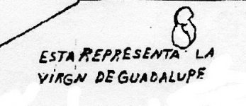
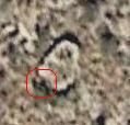
Also they give the clue how the site of the mine should looks like

Virgen de Guadalupe.jpg

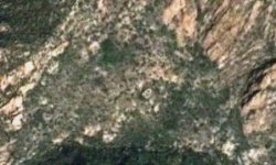
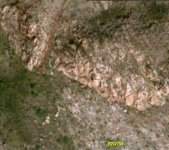
Now look at this GE image which shows the region and almost in the middle ( to the right ) , what have remained of the mine site after they blowed it up .

Vergine de Guadalupe.jpg
 

View attachment 1631316

I guess that depends of which version of the map you end up with. The first one I was given from Ron Quinn was different from this one I photographed in 2001 with permission from an infamous Treasure Hunter that lived and breathed for this Treasure.

He still does hunt for it to this day.

I went after this map looking for one symbol that I recognized in it.

A Cemetery.

The map showed me where that cemetery was at even before I went there. It ended up being the cemetery for San Ceyantano De Tumacacori before I even knew it was that original first location of Tumacacori so it has some validity to it. With so many versions that've been manufactured or manipulated of the original map, if there truly is an original map or it's a fake, it's like old Travis Tumlinson's stone maps...

Which version do you believe is real?

Pick one and go find it.


Bill , of course the treasure of Tumacacori is real as its map . Want you something to see about ?

View attachment 1630750

Look at the map and you can see they give a clue of how the region of the Virgen de Guadalupe should looks like .

View attachment 1630751

Also they give the clue how the site of the mine should looks like

View attachment 1630752

Now look at this GE image which shows the region and almost in the middle ( to the right ) , what have remained of the mine site after they blowed it up .

View attachment 1630758
 

Bill

I have both maps of Tumacacori , and a supplement of a crop from a very old map which shows how the Virgen site looks like .

Want you to visit a site that could be of the La Purisima Concepcion mine ? Has a copper door and could be attached to the mines with a specific kind of metal door like in your thread .
This is an aerial pic of the LPC site . You can see the " Pass of Janos " ( red line ) and below the mine site .

LPC.jpg
 

Is it possible that the = on the PSM represents the iron door located in front of the church represented by the cross inside the parentheses on said map? " in a tunnel or vault 2, 281 varas (about 57 years) south of the church door." I think they meant yards not years...From lost mines of Tayopa...Though the distance still would not make sense...

Who can say for certain?

Ed T:)
 

Last edited:
Bill

To close the debate on the Tumacacori keeping the thread on track , I post a close up of the Virgen site of a GE image . Is good to have it in your collection , even if for now is the only way to see it . In the red shape are the " dos picachos que fueron derrunbados sobre la Mina " .

VdG.jpg
 

Bill

To close the debate on the Tumacacori keeping the thread on track , I post a close up of the Virgen site of a GE image . Is good to have it in your collection , even if for now is the only way to see it . In the red shape are the " dos picachos que fueron derrunbados sobre la Mina " .

View attachment 1631438

The debate will never be closed my friend, that is, until it's proved to be a real map and not a Manuel Ortiz fake from Nogales. I think I may know where the real map is and it's going to be hard to access and take a photo. I guess if you believe in one of the maps you could consider it solvable from that perspective. I've seen some of what this one map map shows in a Spanish Mining district which brings up the clue this may be a land grant area mining claim. It reads like a Jesuit Treasure Map in one way and a Hacienda owner map in another way.

It sure is fun looking for though!!

Bill , for sure the Jesuits had treasures and were haciendas owners . So , the map could be considered a Jesuit treasure map . They always used in their treasure maps as orientation , mines , a chuch , buildings and different other landmarks that would been easy recognizable in the field .
The map which was posted by me , is more accurate than the other that was posted by you . The only accurate in your map , are the words " Monumento puntas roca divercion " which show exactly what the words say .
In the map posted by me , all the clues are exactly where the map shows them . But , to read correct the map , you have to take in consideration how the most distances are measured in legua ( distance per one hour walking ) , so the map has not the proportion that you see . Is more longer from the church side to the Virgen side ( because is more easy to walk in that direction ) than from Purisima Concepcion to San Pedro .
For example , the first half legua from the church to the Virgen site , is the same distance with the next one legua ( the terrain turns more difficult ) . Also , the three leguas from the Virgen site to La Purisima Concepcion site , are almost the same distance with the one legua ( after the half legua ) from the church to the Virgen mine site .
For this are the lines in the map , to calculate degrees in regards to find the correct sites in comparison with the landmarks which are depicted in the map .
If you know where the old Tumacacori mission site is , the " Monumento puntas roca divercion " and the San Ramon water , i believe you could decipher the map .
BTW , according with the map , the Santa Isabel mine is about 500 yards off the wilderness border line .

I know the map I posted is partially real.

The one you have I've never seen before and it looks even faker than the one Ron Quinn gave me!

The map I posted was given to me by a man that had dedicated his life since the early 1960's to treasure hunting. He said that he went to an old library in Mexico and used one of the first copy machines ever built to copy that Treasure of Tumacacori map. He told me it purposely has a few lines and words missing that he didn't want to give out. You can see where some of the lines were erased if you blow it up. But, never the less, this probably is a true copy of the original that came from a Jesuit Mission Rectory hiding place a young Mexican boy discovered while playing around an old Mission ruin in the late 1800's. Don Page talks of this in his notes. Don was Arizona's earliest Archeologist and Treasure Hunter and had access to information about the Jesuits and Gold Mines we can only dream of. He died suddenly in the 1950's of a heart attack and his map collection mysteriously went missing. It was rumored he had many similar maps that he acquired from talking with the man that was the young boy from the 1800's who showed him where the hiding place in the Mission complex's was located. Don went around to every mission ruin he could find and collected these maps for his vast Mission Gold Mine and Treasure map portfolio.

Whomever you received that map from is trying to deceive you. It reminds me of an earlier Treasure Hunting group that came down here after I posted that copy of my map on Treasure Net many years ago and tried to silence me with an agreement I would not sign. Those guys were so underhanded they would manufacture fake map's and propaganda just to keep any others away from the real maps and the main location they were looking at. I know because they were trying to do this to me.

The map you have is a very poor fake at best. It's one of the most faked maps behind the Julia Thomas Lost Dutchman maps in this area. I wonder if old Travis Tumlinson ever had a go at this map? He didn't because this map was discovered in Mexico by the man I'm talking about in the 1960's while researching Don Page's papers. So the provenance of this map is well known and all others are simply fakes or like this real one have lines omitted.

Sorry to be the one to tell you. If you really want to meet the Treasure Hunter and see the real map I have his phone number and address. I'll have to call him first for permission to send you down there.

To Tumacacori Arizona that is....origin of the Treasure itself!
 

Bill

How somebody can understand if a map is a fake copy ? I believe because the landmarks in the map have not the proper distance and angles between them like are in the reality . So , your map is not inaccurate because are missing some lines and words , but because the landmarks are not at the correct place and this modify the real angles of the lines .
But like you said , the best map is the one you believe is the accurate one . For me , have worked the map I posted , and if you want I can prove that . Have worked your map for you ? Have you found anything written in that map ?
 

Bill

To close with the Tumacacori map , i will post a GE image with the San Pedro mine site . They left on the nearest saddles two arrastras almost intact . You can see them in the picture ( yellow circles ) , and the arrow shows the direction to the mine .
If you want , i will give you ( PM ) the Santa Isabel mine site , just to see all these are not BS .

View attachment 1633284
 

What legally ,can u do if u found something of great significants, but it's on state property??
 

What legally ,can u do if u found something of great significants, but it's on state property??

You could try to file a treasure trove claim on it. You would need to get photos of the find and provide as much documentation as you can get to support your claim.

:coffee2:coffee2: :coffee:
 

State Land Treasures are not for trove. They all belong to the state according to the laws of the state of AZ. Only large mining claims are allowed on state land. If you think you have a gold deposit just file a claim and go through the process. I would suggest acquiring an EZ RES like the one I have for finding any ore bodies or tunnels previously dug containing Gold. Get the permit and drill or survey the suspected area of discovery. If it's there it'll show up. Like the GEO company told me before they surveyed my spot. The expert VLF Geologist told me if there's something down there it'll show up and he'd never found a thing in the 15 years he'd been surveying for various mining companies, individuals. He ate his words rather fast after the first survey showed a huge anomaly at 60-90 feet down! This was verified by my EZ RES as being a void with Gold in the bottom which I believe to be a huge Breccia Pipe Gold Vein. That's the kind of Treasure I like. It's like finding the Lost Dutchman. Just a rich Gold mine is all, no Treasure, only a natural one worked before this became America and hidden from view of any prospectors or miners!
I charge a fee for my services plus expenses for surveying a small area if you grid it off yourself like I did. Still, hiring a well know Geologist for the survey is the best way to prove a find and satisfy any would be backers of your venture.
 

Stories like the Iron door treasure cave variants rose to popular reading during the time of the great depression, it was a way to escape the poverty and broken dreams and have a delicious pipe dream about 'hitting it big'. Cheap magazines and dime novels found a rich market mining the pockets of the depression era public. And you know, if you saw it in writing, well it must be true, right?


The Iron Door Mine was first mentioned in a news papers I believe in 1880. So that predates the depression era theory. The Legend had been around since the later part of the 1700's according to a Priest Don Page talked with as he was born in the mid 1800's and heard the story from his family I believe. I know it predates the Dutchman mine story. A lot of legends of lost mines came to be because of all the Indian activity and raids of working mines killing off the owners and destroying the entrances. Mexican on Mexican raids probably were also a problem. Like the Dutchman story he killed for gold. They probably did to.

The entrances to these mines were not large by any means. Very easy to conceal or booby trap. Even the storage vaults had death traps small but effective. I would love to stumble into one of those! They were near surface and had easy access!
I came across one once. I didn't know at the time I had found the Arrastra associated with it. So I just saw it as a curiosity out of Tiger Kenworthy's book. Until I sat down and had a chance to read the whole book not just flip through it. I lost the GPS I was using for the location and never made it back there! I know the general area. It floods quite often.
 

Sorry Folks,

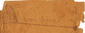
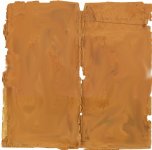
But if your Tumacacori Guadalupe Treasure Map is black and white, it is 99% likely to contain fraudulent information. I say 99% but believe 100% because I have never seen a 100% accurate copy, but one may turn up some day. The oldest known version of the map is (about) 1886. It was the map given to Judge Barnes by the ragged Priest. It is drawn in pencil on a very old piece of Manilla Paper that at one time served as an "end paper" for a much older book. The story most people know says the map disappeared.........but it didn't. It just went into a private collection.

Here is the top right corner of the map:

BarnesMap.JPG

Here is what the entire map looks like. I have altered some of the edges and smudged out all of the map except the upper right corner that I posted:

JudgeBarnesMapSmudged.jpg

This shows the map exists. It also won't allow anybody to "edit in" map data. If the edges don't match the original. It aint real! Everybody; if anyone shows you this complete map and the edges are the same as this one...............its a fake. If anybody offers anyone this map, I ask you to cut out all the middle and email me the outer edges, and I will tell you if it is authentic to my copy.

I haven't seen any older.

AZQuester, if you knew Ron, my guess is your old timer in Tumacacori is named Dan? Nice wife? Nice dog? Couldn't be Gary Oliver, as he lives in Oregon, and as far as I know, hasn't been to his old Treasure Trove Site since the late 1990s.

Best of luck - Mike
 

Last edited:
AZQuester,

I don't believe you are correct in your assertions regarding Treasure Trove. It would depend on where your find is located. If it is on State or State Trust land, then yes, the state would fight you tooth and nail for every fleck of gold. If your find is in a National Park or National Forest (like Coronado Natl Forest) regular treasure trove rules apply. You don't have to do anything with the state. Your TT Contract is negotiated with the US GSA (United States General Services Administration). You have to have a recognized Archaeologist do an Archaeological Survey of your site to make sure you don't dig into an Indian Burial Ground or other historically significant site. Then, depending on whether you plan to dig using only a pick and shovel or, up to heavy equipment like a Cat D9, you will be required to file a "Reclamation Bond". This ensures that after you are finished digging, you will return the entire area to as good or better than it was before you started. This will be somewhere between a couple of thousand dollars and half a million dollars. If your find is on private property, the state loses out. Treasure Trove also trumps the current land owner (unless they were the one that hid the treasure).

Mike
 

Hello Gollum

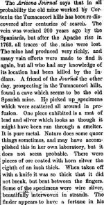
The following newspaper article may be of interest. Las Animas Leader, Volume 3, Number 15, September 17, 1875

Las Animas Leader, Volume 3, Number 15, September 17, 1875.jpg

The Article mentions many mines but one mine it mentions Ore from the Tumacacori mine 80 mile south of Tucson that was very rich. And for some 3 times richer than the silver king. A famous wealthy silver mine north of Tucson that sold for 200 thousand in 1875.The Silver King mine operated from 1875 to 1889, and again 1918 to 1928, producing 6.2 million troy ounces (190 metric tons) of silver

1875 was in a uncertain era because the region was still in throes of the Apaches wars. It would be easy to see why a silver lode like Tumacacori being abandoned because of the conflict?

Now you mentioned a cave?

You might find the following newspaper story interesting? Dolores News, May 14, 1881

Dolores News, May 14, 1881.jpg

While I concede it is hard to put a name of the correct mine on a hole in ground as thee mine? But interesting no less. I do believe the copy you have is one of the oldest copies.

I recall not to much detail that the ragged priest made a deal he was only interested in the silver hidden under the altar of the church. The mines was given to some local men as part of the deal for their help. Hence the map ended up in possession of Judge Barnes.

I do think also the map was a true copy but like you said all maps are not entirely accurate.

Kanacki
 

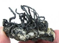
Here is an example of wire silver.

silver-wire.jpg

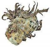
Another example of silver remaining with matrix has broken away.

thumbnail.jpg

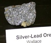
The purity level can vary with silver as some times the silver is mixed with lead.

silver_lead.jpg

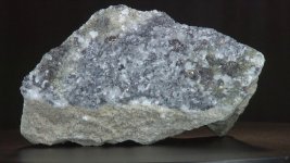
As you can see an example of silver lead ore below.Here is silver lead ore from the famous Silver King mine 100 miles north of Tucson.

SILVER KING ORE.jpg

As reported in the Tumacacori mine was more concentrated in native silver occurring in the fractures of geothermal veins fractures and not in host rock surrounding it. So in short most of hill around Tumacacori mine are barren except for areas that have had faulting created by thermal pressures pushing up metal rich waters. That said any exposed dike or faulting would have veins and tiny fractures of silver just like in above pictures of wire silver. As reported in the above newspaper these small areas have intense concentration of silver.

The silver king 100 miles north has higher concentration of lead with in the ore and much of the silver is impregnated into the surrounding host rock.

While the ore bodies around the Tumacacori mine are small and not likely worth the effort of big modern mining companies. They would of been very attractive historically due to mining practices of the time. Being very rich in ounces per ton. they would in their day been very valuable indeed.

It would be easy to see why The early Spanish and perhaps Jesuits and even the Franciscans was tempted to mine these small but very rich loads?

Kanacki
 

Last edited:
It should be noted in above pictures the color variation of silver is due to the amount of exposure to sulfur. The longer silver is exposed to atmosphere with trace elements of sulfur the darker it becomes.

Kanacki
 

Last edited:

Top Member Reactions

Users who are viewing this thread

Back
Top