Mine near squaw valley

Hello Mr Roberts,

Thank you for your enlightening response. I believe those mountains hold more secrets than what has been revealed. In your opinion, do you think that there could be another entrance to that hole in the ground?

Thanks,
oldpueblo


oldpueblo,

Personally I don't believe so, but I cannot say for sure. Over the years I have learned anything is possible in those mountains.

I think someone with enough money, time, resources and energy might be able to take equipment there and somehow photograph whats in that hole. Just getting to that place takes a considerable effort, its not a leisurely hike down a well worn trail a few miles from the trail head. Modern technology is nice but somehow I can't bring myself to even carry a GPS unit. If I ever find the mine I'm looking for, it will be the same way the Mexicans or the early anglos found it.

I would give anyone the same warning I received, and gave to my two friends, don't go down in that hole, leave it be, some things are better left as they are.

Matthew
 

Wonder what it would take to put together a battery powered light/fiber optic camera to look around in some of those old holes - even ones that are 50-100 feet deep? I imagine snaking something around rocks and angles would be tough, but where there's a will, there's a way.

Your best bet would be a tethered camera robot with fat tracks like this one:

superdroid

This one is pretty expensive, but there are cheaper versions, I'm sure.
 

Last edited:
A GoPro or something similar, and a couple of led flashlights taped together..... in some kind of protective but open frame.
Turn it all on and lower it down as far as it will go.
Wouldn't be too hard to build a remote controlled crawler, using a toy tank or 4x4 truck with a couple of cheap pocket video cameras and LED lighting.
Some of those toys are quite powerful and agile. Certainly safer than going in yourself for a first look.

https://i.pinimg.com/736x/5a/4a/c2/5a4ac27230adf9af1ee0a08c25709a93--arduino-motors.jpg
 

Last edited:
This would be a good foundation:

alloy tank robot chassis

I would tether it rather than use wifi. That way, if it gets stuck or malfunctions, you can just pull it back out.
 

As an eBay Associate we earn from qualifying purchases.
Yes for a tether. Or at least a strong line with which to pull it back or out when necessary.
Maybe one or two cameras recording and one wi-fi for real time view to the android device for guidance.
But a full control tether setup would eliminate any chance of radio interference or signal loss.
 

chiin-tuh-yo.jpg pesh litsog pesh o'odo.jpg
 

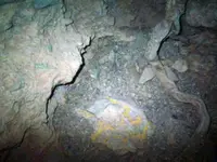
I'd also say it looks like an older dig/mine. Copper sulfate deposits on the wall.....maybe even turquoise ?
Regardless of native superstitions about the place, it seems someone was able to do all that work without falling victim to any spirits or whatever it is that spooks them.
If that second photo IS the bottom of the shaft, it's very clean and tidy down there.

the first people that worked the mine wern't under any curse...something real bad happened to them at that location and they cursed it...i wouldn't go down in that mine ...the blue on the wall would be copper oxides...probably chrysocolla
 

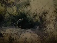
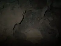
The Matthew's pics are from two different mines ( concluded from the pics titles ) , The first is of the cursed shaft/hole from Doc region , and the second is of the Camp mine from which ore was made a ring .

PS

Also the tree root in the second pic shows how the mine is close to the ground surface level .
 

Last edited:
View attachment 1583154

azdave35,

Something interesting about that area.

The area circled by Doc4261 is up at the top of Squaw Canyon, actually the correct name is New Squaw Canyon. The real Squaw Canyon, or Old Squaw Canyon, is one canyon to the south. When the Forest Service gave information for the updated topo maps someone who didn’t know which canyon was which marked the wrong one and today everyone recognizes it as Squaw Canyon. Old timers however still refer to the canyon to the South as Squaw Canyon and it causes confusion with the younger crowd. There are numerous errors of misnamed canyons and sites by the Forest Service on today’s topo maps all over the Superstitions.

There was an old trail coming up out of LaBarge Canyon at Marsh Valley that followed up (New) Squaw Canyon. That trail is impassable today due to erosion and Crazy Jake using dynamite on it. If you followed that trail all the way to the top you would be standing at the northwest end of the area Doc4261 circled. That circled area is a fault, the north side being the hanging wall and the south side the footwall. I’ve been in that area many times. Walter Gassler’s camp in the grove of Laural trees was just to the east of that circled area about 1000 feet away and John and Joe Kochera found their rotted leather sack of gold ore just to the southeast of the circled area.

Walter Gassler showed me an old mine / hole in the ground over by that circled area. He was afraid to go down in it and when I saw it I could see why. The entrance was a down shaft in solid rock. You could stand on a small ledge about 6-7 feet down but the ledge was slanted and not very big and was dangerous. From that ledge you could look down but couldn’t see the bottom because the shaft angled off to the north a little. It was hard to judge how deep the shaft was from the ledge but it was between 70-90 feet.

Ropes would be a must for going down and it would be a three man endeavor at the very least. Two men above and one going down. After Walter died I forgot about it until one day I was on Peters Mesa with a friend from San Carlos and we got to talking and I told him about Walter’s mine / hole in the ground over there and asked if he knew anything about it. He did know about it and warned me about going in and then proceeded to tell me a pretty hair raising story about it.
The next day we went over to the hole and I let him lead the way to make sure we were talking about the same place. He made a bee line right for it and never wavered or seemed not to know where he was going.

Years later Greg Davis was with me and I showed it to him. Greg said one day he would like to go down and explore it. I gave Greg the same warning my friend gave me and said it was best to just leave it alone. Sometime after that I learned Greg and Jack Carlson were out there and Jack attempted to go down but got only as far as the ledge. With a light he could not see the bottom and bees had made a home down in the shaft somewhere. I was relieved Greg and Jack had not attempted to go in. According to my friend from San Carlos, whoever goes in, never comes back out and there is something terrifying at the bottom.

Matthew


Thanks for the info , do have another thing that has been on my mind, was the cave on malapais that supposedly had a pic of the Dutchman. is it on the north side or south side of malapais. Havent seen much on it but can u clue me in on where that is in regards to that mine. ruling out all the little things that could or couldn't make sense as u seem to be very knowledgeable on the subject. Im not sold the pit mine is the Dutchman.
 

Thanks for the info , do have another thing that has been on my mind, was the cave on malapais that supposedly had a pic of the Dutchman. is it on the north side or south side of malapais. Havent seen much on it but can u clue me in on where that is in regards to that mine. ruling out all the little things that could or couldn't make sense as u seem to be very knowledgeable on the subject. Im not sold the pit mine is the Dutchman.

Doc4261,

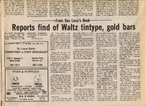
I believe you are talking about the tintype photo of Jacob Waltz the Dutchman.

That tintype was not found in a cave on Malapais it was found at the bottom of a 25 foot mineshaft in the Goldfield Mountains in 1971 by Das Lucas (a Frenchman).

I don't recall any pic of the Dutchman in a cave on Malapais. The article tells of the discovery of the photograph and other items found at the same time.

Matthew

Das Luca Article pg 18-B.jpg
 

The Matthew's pics are from two different mines ( concluded from the pics titles ) , The first is of the cursed shaft/hole from Doc region , and the second is of the Camp mine from which ore was made a ring .

PS

Also the tree root in the second pic shows how the mine is close to the ground surface level .


markmar,

The "tree root" is actually debris from sticks and limbs and grass that littered the bottom of the mine over the course of a century or more. The mine is not shallow.

Best,

Matthew
 

That's all part of the ironwood cover old Waltz put on top the shaft before he sealed it! Eureka! The Dutchman was discovered and worked already! No more gold might as well stop looking...
That's what you call the Peach Pit mine because it's surely a peach of a pit! Go down there and you'll be a daisy if ya do! Or a Huckleberry!
 

Doc4261,

I believe you are talking about the tintype photo of Jacob Waltz the Dutchman.

That tintype was not found in a cave on Malapais it was found at the bottom of a 25 foot mineshaft in the Goldfield Mountains in 1971 by Das Lucas (a Frenchman).

I don't recall any pic of the Dutchman in a cave on Malapais. The article tells of the discovery of the photograph and other items found at the same time.

Matthew

View attachment 1584857


Thanks , that is interesting.
 

View attachment 1583154

azdave35,

Something interesting about that area.

The area circled by Doc4261 is up at the top of Squaw Canyon, actually the correct name is New Squaw Canyon. The real Squaw Canyon, or Old Squaw Canyon, is one canyon to the south. When the Forest Service gave information for the updated topo maps someone who didn’t know which canyon was which marked the wrong one and today everyone recognizes it as Squaw Canyon. Old timers however still refer to the canyon to the South as Squaw Canyon and it causes confusion with the younger crowd. There are numerous errors of misnamed canyons and sites by the Forest Service on today’s topo maps all over the Superstitions.

There was an old trail coming up out of LaBarge Canyon at Marsh Valley that followed up (New) Squaw Canyon. That trail is impassable today due to erosion and Crazy Jake using dynamite on it. If you followed that trail all the way to the top you would be standing at the northwest end of the area Doc4261 circled. That circled area is a fault, the north side being the hanging wall and the south side the footwall. I’ve been in that area many times. Walter Gassler’s camp in the grove of Laural trees was just to the east of that circled area about 1000 feet away and John and Joe Kochera found their rotted leather sack of gold ore just to the southeast of the circled area.

Walter Gassler showed me an old mine / hole in the ground over by that circled area. He was afraid to go down in it and when I saw it I could see why. The entrance was a down shaft in solid rock. You could stand on a small ledge about 6-7 feet down but the ledge was slanted and not very big and was dangerous. From that ledge you could look down but couldn’t see the bottom because the shaft angled off to the north a little. It was hard to judge how deep the shaft was from the ledge but it was between 70-90 feet.

Ropes would be a must for going down and it would be a three man endeavor at the very least. Two men above and one going down. After Walter died I forgot about it until one day I was on Peters Mesa with a friend from San Carlos and we got to talking and I told him about Walter’s mine / hole in the ground over there and asked if he knew anything about it. He did know about it and warned me about going in and then proceeded to tell me a pretty hair raising story about it.
The next day we went over to the hole and I let him lead the way to make sure we were talking about the same place. He made a bee line right for it and never wavered or seemed not to know where he was going.

Years later Greg Davis was with me and I showed it to him. Greg said one day he would like to go down and explore it. I gave Greg the same warning my friend gave me and said it was best to just leave it alone. Sometime after that I learned Greg and Jack Carlson were out there and Jack attempted to go down but got only as far as the ledge. With a light he could not see the bottom and bees had made a home down in the shaft somewhere. I was relieved Greg and Jack had not attempted to go in. According to my friend from San Carlos, whoever goes in, never comes back out and there is something terrifying at the bottom.

Matthew


Another question, By chance is there a very Large rock by that mine , as I believe all the mines were marked with a large Rock.
 

Another question, By chance is there a very Large rock by that mine , as I believe all the mines were marked with a large Rock.

Not trying to be snotty or snarky or anything, but there are large rocks EVERYWHERE out there no?
 

Top Member Reactions

Users who are viewing this thread

Back
Top