Mariposa county / Maxwell creek private land

Jbarsk8

Jr. Member
Joined
Mar 13, 2016
Messages
71
Reaction score
118
Golden Thread
0
Primary Interest:
All Treasure Hunting
Hi all-

Lurked for a long time around here but finally decided to see what my property has to offer. I'm in the coulterville area on my private ranch. I have numerous drainages on my property that eventually end up in Maxwell creek. These drainages are thousands of feet long, and start at an elevation of about 3000-3500 feet in elevation and drop to roughly 2k feet in elevation before entering my neighbors ranch where Maxwell runs through. The neighbors have been there since the 49r days so gold is obviously there and they have a couple hard rock tunnel mines on their land that they haven't worked in at least 50-75 years. There are numerous tailing type piles on my land, although I have yet to find a tunnel. There are roads that you can see carved into the sides of the hills on my ranch going to some precarious places which are now completely overgrown. I can only imagine if these roads or trails are in these areas, they must be for very good reason because it is not easy travels to say the least. I also have two of the best springs in the area that run year round even in the worst of droughts. I'm telling you all this just to paint a brief history and of my thought process as I'm certainly new to this.

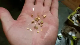
Anyways, I bought a little yellow jacket 36" sluice and figured I'd look on my property to see if there was any type of placer in my drainages. First spot I went to was the spring. I dug a decent hole behind a nice "knob" of bedrock in the spring area and found a few nice specs and some decent flour gold. This wasn't even a proper hole down to bedrock. I'll have to go back. I know there is gold eroding from somewhere above this drainage point now, so I decided to go to the drainage behind my cabin which looks much more mild, less steep and doesn't flow nearly the water, only flows a few times a year during rainiest times. I found a nice little spot where the bedrock drops a foot or two into a "hole" of bedrock. I cleaned it out decently, certainly not as precise or in depth as I could have gone and I again, got some nice colors but also got a little picker that I saw sitting in the sluice before panning! I can't tell you how excited I was. The reason I'm writing this isn't to boast or brag, the fact is the number value is small. What I'm most excited about is that the gold is on my ranch. Because my ranch is a big hill (80 acres) and flows into Maxwell, does this mean that this gold has to be eroding from a vein somewhere above me on my land? These drainages pretty much start on my property at the peak of the hill. Because gold can't travel up stream my understanding is it must be from somewhere on the face of my property? Please correct me if I'm wrong. I'm not in a hurry to find the gold as it isn't going anywhere and I'm never selling this place, but what would you folks do? I have a lot of free time for the next few months which happens to be when the water is flowing. I feel like a newbie at this and if I found this little gold in 2 days with minimal effort and knowledge my thinking is there has to be some nice deposits here. With the best springs in the area on my land, all the gold activity in this area back in the day, and even all the hand forged tools I've found on my land (axes, rock hammers, etc....) I figure there must be a lot here that was missed ? Maybe I'm being naive I don't know, but please if you have any thoughts or suggestions share them. I'll try to put up a picture of the "picker!" Thank you for reading.
 

Last edited:
Upvote 1
Hoserjohn-

Thanks for stopping in! I love bagby. I actually bought my land after camping on the Merced near bagby back in high school and telling myself I wanted to live here one day. It's a magical place. Eagledown was a big inspiration RIP, although I never got to meet him, I still read and reread his thread because the knowledge of my local area in that thread is incredible. The conservation dept and joining a club are awesome suggestions, thank you very much.
 

View attachment 1398898

A couple hand tools I've found. That axe head is incredibly heavy. Must be made of almost pure iron. When I was going to take this pic I noticed a faded but obvious "star" type engraving or logo on the bottom.
Looking at the hill picture based on the buckbrush and Grey(digger) pine I would say your in an area with serpentine that's a good thing. Look for where quartz is contacting green rock in the area . Do you have slate? You should.

The hammer on the left is no more than thirty years old I would say it was where you found it no more than ten.The axe head is typical for the mother lode. There is a good chance that it was used as a wedge to split bedrock . That's why it's beat up on the backend. Someone could have been hitting it as a maul in wood but they don't wear as heavy when your splitting wood.
Both are indicators of placering one old one recent. Large property is hard to keep high graders off of. Joining a local club is great advice. However no matter how friendly and innocent DO NOT just start inviting people to your ranch to help you look for gold. Someone will comeback or tell someone and they will come check it out.
Stacks of rock next to the creek are also a good sign. If it seems like they bunched stuff together in certain areas that's where they were finding color. And I would investigate the hillside there for veins. The seasonality of most of our creeks doesn't move the gold very far from the source. Look for stringers crossing the creek too.
If you find moved rock the whole way along the stream they were finding gold the whole way. If a good majority of the stream gravel is quartz it's also a good sign.
If you are on slate sample the stretches where the creek runs perpendicular to the bedrock. Use a big screw driver to flake pieces apart. Pan the material from in between.
If you start finding color use a prybar for bigger cracks. Don't neglect smooth slate dig out any crack you find in the smooth slate. The rough choppy stuff is good at catching gold but if you see it exposed most of the time that is the last stuff the old timers were breaking apart.
Your property being an old large property has a lot going for it as even though it has been high graded GAURANTEED!! it is less accessible to serious focused work. That's your luxury now. Use mylandmatters it will have heaps of old mine info. Try to find one mine on or close to your land. That you can positively Identify. You can then have a known fact to cross reference on for geology,geography and history.
 

Last edited:
And don't let anyone convince you that the "old timers" were so great at getting the gold.
About 2 % were good and also on stupid rich ground...the other 98 % really sucked at it and we're on stupid rich ground...and they were fickle as hell and would chase new leads often leaving good gold inches away.
I look for areas last worked by the 49 ers whenever I can.
 

Attachments

  • 1483806607713.webp
    1483806607713.webp
    15.8 KB · Views: 143
  • 1483806623030.webp
    1483806623030.webp
    21.6 KB · Views: 150
Goldwasher
Thank you sir for taking the time.you obviously are a knowledgeable person. I am located on serpentine, I know that for a fact. There are many parts of the land where bedrock is on the surface or very close. Any yes, those are all digger pines. I'm not educated enough in rocks to be able to determine the amount of slate. When I think of slate I think of thin sheets of easily breakable rock. The stuff I see is dark and very hard and seems to have a large amount of metallic content, very dense and heavy. I can't think off the top of my head where quartz meets a green rock (mariposite maybe) but there is a tremendous amount of quartz everywhere, from veins feet thick to little stringers of rotten degraded looking quartz.
Sorry for my ignorance but what are highgraders? I know mining was done here back in the day. One of my large ravines even appears to have been hydraulic mined back in the day just based on old satellite pics and the barren look of the drainage. In these areas the ground just looks very odd to me. Lots of mini little gullys or pits that seem very out of place but are now grown back in. When I go into the drainage(s), which there are 3 or 4 major ones on my ranch, there are some areas that seem to have minimal rock ( where I found the picker) and other areas with large rocks and boulders. It's very hard for me to tell if this was due to erosion or moved there, as some area very large. Given the seasonality of the rains like you said, I think it would take a tremendous amount of rain to move these things. I can't thank you enough for your knowledge. I just want to approach this in an efficient manner and hopefully avoid walking around like a chicken with my head cut off. Your pics were incredible and that gold is gorgeous. What methods do you use to find it?
 

Jbar, This is a great story and I'm hoping you will keep it going. Best of luck to you in your prospecting!
 

Sniping cracks and shoveling gravel. Sluice and gold pan....and after the last storm some just picked out of exposed cracks.

Highgrading is when someone trespasses and takes whatever it is you are mining. Be it on your claim or property. Most of the best snipers (success wise) in the mother lode are unfortunately high graders as well. they like to keep boundaries fuzzy and you will hear often "well he should mark his claim." Unless a previous owner lost or gave permission for someone to prospect on your ranch, that two pound hammer belonged to a high grader. The more people that know gold has been found on your land the higher your chances for visits goes up. Don't add to that percentage if you can help it.
Claim jumping is also used as a term for high grading. Claim Jumping is when someone files a claim over your claim.
Here is a general geology map of your area http://www.appliedminex.com/decrep/calif/molodec.png You will know generally where your ranch is scroll to the bottom of the map. Learn the key to the formations. read what types of rock and minerals are in each. Study those so you can ID them in the field Luckily most of the rock in the Mariposa and Calaveras formation are readily identifiable. Even with their geographical variances. Put on a blind fold and get dropped off at 600 to 3k feet from the Middle fork of the American down to your area and you would most likely not be able to guess at where your at other than in the foothills. Many of the things that matter most to prospectors are very similar from here to there.
There are "high resolution" geology maps here as well as a library containing many reports from the State Division of Mines and other agencies and their different forms over the years. Learn to use the maps and especially the info tool and the way it will tell you about the reports that are available for that area. http://mylandmatters.org/Maps/GeologyCA/GetMap It says "high resolution" but, when your in one of your dranages it will be even HIGHER resolution. As in you will see slate with small contacts of https://en.wikipedia.org/wiki/Porphyry_(geology) and you'll notice that your in an area on the map where it mentions those rock types as common to that formation.You'll get a good idea of what to look for. The reports mention the rock types at the mines.
 

Last edited:
First off, welcome Jbarsk8. I just now caught up on your post and love it! When I came to CA and moved in right next to a gold bearing river, i was disappointed BECAUSE I didn't get results like yours right away. Then, I learned about the mother lode country and frankly, got jealous pretty quick. While I've learned how to find it here, your the kid in a candy store and after your first picker, I know of your excitement. Good luck, watch your 6* and please keep us posted.

*Be cautious new friend, undesirables also use the internet for wrongful gain.
 

Wildminer
Thank you sir, I will definitely do my best. The knowledge around here is an incredible thing!
 

Goldwasher
Thanks again for stopping by. On that map, it's a little hard to tell but I'm either in the serpentine section or the greenstone, amphibolite, chlorite schist section. The reason I said yes to serpentine previously is because my spouse works in environmental health doing a lot of things like land surveys and even septic inspections and such and she told me long ago that I'm on serpentine so I just trusted her opinion. I'm not far at all from the Mary Harrison mine. Moccasin, coulterville, and Mary Harrison are basically my home.
Thank you also for the clarification on high grading. I'm sure that does happen often, don't get me wrong but to do that on my ranch seems fairly unlikely and far in between to me. There are MUCH more accessible places let's just say. I'm surrounded by very large ranches some being 500 acres, their land all has gold too, why trek through to mine? The best and national forest is on the north east end but you'd have to hike miles through unforgiving brush and then come down over the face of my mountain. On top of that, all of my neighbors are gun toting rednecks and I mean that in a very loving manner. I love hearing them shooting their automatics off, no one calls the cops here! I've owned my place for 5 years. The previous owner 15 years. That's 20 years of no mining. The previous owner certainly may have done something. There is an old Caterpillar D7 from the 30s I believe sitting near my cabin that I inherited in the land purchase and I think it was his. Looking back on old maps you can see some very interesting cutouts and roads that were probably done by him with this dozer. Obviously it's mostly grown back in now, but just analyzing the land and getting an intimate feel for it, you can see tons of work and cuts and such leading to odd places. Some of them in the last 50 years and I can only imagine they were at minimum exploratory work gaining access to areas because these chaparral forests are hard to walk through unless your in the oak tree spines. The chemise and manzanita are crazy to walk through. It literally turns into a military crawl on all 4s and you're barely moving.
Mylandmatters seems like an incredible resource I will use, unfortunately it doesn't seem to work well or maybe not properly on my phone? My connection is frequently bad, maybe that's the issue. I can't seem to zoom in on my area to even be able to see anything. As far as the porphyry rock, I haven't seen any big red ones like that but definitely smaller red ones and even dark ones that have crystal or quartz type formations which look almost like granite however I do not think it is. Thanks again for sharing your knowledge.
 

Jeff95531
Thanks for popping in! I love your region. I've spent some time up there for sure and done lots of business in areas like garberville, shelter cove, redway, and honeydew. Reminds me a lot of Alaska but not as cold obviously. Thank you for the advice. People would be crazy to trespass in my area. Neighbors are nuts and will flag down cars in the middle of the road if they look out of place, and the sheriff seems to support it. Oh ya, what sheriff ? To anyone that tries to use the net for wrongful gain, smile, you're on camera!!! Thanks for all the tips folks, very much appreciated.
 

Hey Jbarsk8,

I know the area well. Do some research on eluvial placers, that is gold that has broken free of the vein (lode) that is working its way down the hill to the creeks (alluvial placer). Lode, eluvial and alluvial were all mined around that area and more than likely on your ranch, just about every drainage in that area has been worked at some point. There are road cuts on all the hills in the area, I believe these were research cuts looking for deposits. The hills are so full of brush, grasses and soil that makes seeing the native rock difficult so they would scrape it away and look to see what was underneath. I would work the very center of the more prominent drainages on your property for alluvial placers, be sure to dig the cracks deep. Keep track of what you find and where you find it, you may be able to track where the gold is coming from and find an eluvial and/or lode deposit. Good luck!
 

Jbar you have a lifetime of fun ahead of you. When at Bagby lookout parking lot just look across the river and there is 3 cements steps left of our house and not much else. I'll look for pics from the 50s when it was really a fantastic place to spend summers,holidays and vacations. Bagby was Benton Mills-owned by Senator Benton- who gave the town site to General John Freemont-father of Calif. as a wedding gift. Much history in Mariposa Museum and yet another great place to visit. Our best finds have always been in the black fractured shale as you spread the shards and vapor deposition gold within like golden leaves in a book. Read up on rhodium as mariposa is the only proven producer of commercial amounts of the nasty black,reddish iron oxide looking ore. Were you around when all the gold coins were found in the streets of Coulterville?? What a rush like the gold rush in Sonora when the new water lines diggings brought forth massive amounts of gold? Fun country for sure-John
 

Spillercanyon
What you describe seems spot on with what is going on around here. Seems like scraping and then clearing down to bedrock, which is very close to the surface in some places or just a few feet down. Im very excited to start doing more searching on the ranch. How do you recommend processing the material in the drainage easiest when there isn't water ? Currently, were getting hammered with rain so they have some flow, I can put a sluice in the drainage, dam it up, and process but 95% of the year the only water is in my drainages where the spring flows. I have about 4500 gallons sitting in water tanks at the spring that I could also set something up at. Would I dig material into 5 gallon buckets and transport down to the spring when all else is dry? Thank you for your time sir!
 

Hoser john
Wow! You had a house there? I know exactly what you are speaking of. Fremont seems to own all of the land in and surrounding bagby, as there are no trespassing Fremont signs everywhere. A gold mining company has been doing exploratory work above bagby on the way to mariposa for a few years new drilling test holes gathering data. Some of their samples show large concentrates of gold per ton of ore. How incredible to have a place in bagby! I'm certainly gonna pry open some shale. I can actually access the Merced river via a back route and 4 wheeler that takes me near bagby but to areas that are explored much less commonly as they are off the beaten path. I was not around when the coins were found but have heard many stories. My neighbor owns an old building on Main Street and there are many stories of people remodeling and finding gold hidden in walls and under floor boards. There is still the 75,000 in gold coins lost and never found. So many incredible stories! You must have a wealth of knowledge in the area. If you ever make it down this way I'd love to meet up and hear some stories!
 

Start a log and write down everything you test and exactly where you tested,, how deep was it ,what was found, size and amount. It will start to tell you a story. Sounds like you want a Trommel and back hoe. Good luck keep us posted.
 

The black rock that flakes in the Mother Lode is slate MOther lode fault - california - Structural geology of... You are looking for metamorphic rock. And where it contacts intrusions. It as once shale but, https://en.wikipedia.org/wiki/Metamorphism isn't anymore. The shale that sits deeper in the valley is shale because it hasn't been introduced to plate tectonics like the slate in the mother lode. We do have oil shale in California. https://en.wikipedia.org/wiki/Monterey_Formation https://en.wikipedia.org/wiki/Shale read the details, Proper ID matters a lot to prospectors.

I'm not sniping Johns comments but, in mining shale and slate have differences that matter.
 

Burrows
Thank you sir ! I've already started a log and plan to keep working on that. I'm not at all opposed to spending some real money on equipment but just want to make each step along the way as efficient and worthwhile as possible, especially because I'm a newbie. The good thing about a tractor or backhoe is that I can further develop my land putting more equity into my pocket, not even talking gold.
 

That lack of water is both good and bad. Makes extracting the gold harder and less encouraging at the same time.

Probably easier to move the water to where you want to dig in the end. Some form of recirculating sluice might be the best option. Not sure how far water is from where you plan on digging. Bucket of water weighs less than rocks/dirt. Hoses and a pump might work?
 

Thank you goldwasher. I'm thinking the slate is the dark very dense and hard rock that is in many places. The greenstone is much more soft. Those maps you show are very helpful. I'm definitely in the Paleozoic region and again it's hard to tell but in between or may have both the greenstone chlorite schist and the serpentine on my land. Some of the drainage seems to be littered if greenstone I believe, other sections I believe are the slate and the massive piles of rocks on the hill I believe are slate, but an educated man would be much easier able to identify. I'm doing my best to learn!
 

Top Member Reactions

Users who are viewing this thread

Back
Top Bottom