MA/VT/NH Panning

dvdtharaldson

Full Member
Sep 19, 2012
246
178
Massachusetts
Primary Interest:
All Treasure Hunting
Hi ,

This is the first time I have posted on this website. I live in Western MA and am planning a trip during the last few days of September to Vermont to try my luck panning. I was going to try Buffalo Brook and Five Corners in the Bridgewater area. Does anybody know how far down you ordinarily have to dig to hit black sands in those areas? Any comments on whether you have to dig deep or just stay on the surface? I was thinking Irene probably deposited alot of flood gold on the surface. Does anybody know if some of the small brooks high up in the mts. north of Bridgewater contain gold? All I ever hear is Buffalo Brook and Five Corners. Any advice would be greatly appreciated. As you probably could tell I am new to panning for gold.

Thanks,

David
 

Last edited:
Upvote 0
dvdtharaldson said:
Roadtrip,

I have never personally prospected in Baldwin Creek, but I am familiar with the area. I like to go trout fishing in the headwaters of the New Haven River which is right in the area. The last time I was up there I didnt even know there were colors in Vermont. However you can bet the next time i go up there I will check it out.

David

I've pulled a few trout out of the New Haven river myself. However, I usually catch and release, so it may have been the same one over and over. lol. If the weather isn't too bad next week, I may swing over to Baldwin Creek on my lunch break for some quick panning. I saw one spot with a lot of exposed bedrock on one side of the water.
 

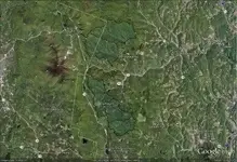
fyi, there are over 20 different gold find records close to these 5 basin fingers.
.
Click here for interactive google map
treasurenet sample 1.jpg
 

Last edited:
Roadtrip,
I to practice catch and release, havent kept a trout in many years. Do you fish the New Haven above or below Rocky Dale? It can be a fickle river, some years I am able to pull out trout after trout, some years I couldnt buy a hit. About four years ago I was fishing the headwaters and caught 15 brook trout in about an hour. That day they were in every pool. I went back a year or so later and didnt even get a rise to my fly. Do you live up that way? I know most people fish it farther down towards the flats for big rainbows, but I have always been a dedicated brook trout fisherman.

David
 

vtgoldprospector aka Corey,

Earlier in this thread I somewhat detailed my trip to this specific area. I had so much fun panning and hiking around that I will be hard pressed to go to a different location in Vermont. I camped at Coolidge State Park and was surrounded by gold bearing streams. While I did not find alot of gold, i am convinced that there is a good amount of it in the area. My physical condition will not allow me to dig down to bedrock, but if I could I would have found more than what I did. Mind you, that I only spent about an hour doing very light digging and found colors. The real value came from the experience of being in a remote setting, not the colors found. For now I will have to be satisfied occasionally panning the barren streams of my native state of Massachusetts. My salvation is that I know that my annual trip to Jamaica State Park in Southern Vermont is only 7 short months away! Yeah I know, I said i wouldnt go anywhere besides Coolidge, but there are still a few foolish friends who dont pan, and wont drive more than 1.5 hours away. As an aside the area really got scoured by Irene and in some places looks like a moonscape. Alot of the mountain streams had to be rebuilt with excavators. Some of the streams like Whetstone brook defy description. Ecological disaster are the closest words I can think of.

Best Wishes,

David
 

Jamaica State Park Photos

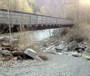
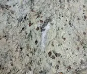
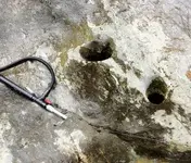
I have personally been to Jamaica State Park. I love the path that runs along the river! Closer to the dam upriver there is a side stream, Cobb Brook. There is so much garnet there it would make your head spin! Boulders the size of cars covered in dots. The cons from a little panning is red! The following photo is where that stream dumps into the river. Only around 200 ft up the brook you will see a few fist sized holes in the rock (on the left), that is where the middle two photos were taken. I really must go there again. :icon_thumleft:

IMG_0520.jpg

IMG_0510.jpg
polka-dotted bolders

IMG_0513.jpg
Rock n' hole

IMG_0521.jpg
Cobb Brook from the foot bridge

ps
I didn't get anything in my test pan but I didn't have the time to find a proper location. After I got back and looked at the photos I realized that the last photo above may show a very good candidate for a test hole. I'll be sure to look closer at it when I go back next time.

Gold Map Maker -- The ultimate prospecting tool!
 

Hey Corey,

Thanks for the pics. I made it down to the spot in your photo a few years ago, I couldn't move for a week after, but I made it down there. About a mile upstream there is a nice waterfall (Hamilton Falls) with alot of exposed bedrock. Cobb brook eminates from about the same place as Turkey Hill Brook which i am told has colors in it. It wouldn't surprize me if Cobb has colors in it as well. About 2 years ago during our yearly trip to Jamaica State Park my friend found a small flake in the West River. That was my introduction to panning and i have been hooked ever since. I eagerly look forward to going to JSP every year. I am hoping to try to access Cobb Brook via the switchbacks at Ball Mountain Dam this coming May. All that depends on how my back holds out though. As to the garnets, I remain perplexed. I never find colors where there is a high concentration of red garnet. I know they have a high specific gravity. It doesn't make sense to me. I dig down far enough to find black sands but never find colors. If you dont mind me asking what has been your experience with red garnet as it relates to the presence of gold?
 

Menotomymaps,
Nice to hear from you. i dont often hear from people who pan the same drainages as I do. My only luck in the Westfield has been in tribs of the Westbranch. Colors for me have been very small and infrequent. I have tried the Eastbranch but no success. But the spot I was in probably wasnt the best choice. I just happened to be there with a group of friends. Eventually I am going to try the middle branch. If you dont mind me asking what branch do you pan? Best Luck.

David

East.
 

To Anybody thats Interested,

I was up in a trib of the East Branch of the Westfield River around Cummington, Ma trying to locate a bit of color. I didn't have any luck finding any. Just alot of purple-black Garnet . Even the black sands were comparitively light. After an hour or two I decided to head up to Windsor for awhile. I found a stream with some greenstone in it and decided to make it my destination for my next panning trip later this month. Has anybody tried panning up in those areas?
 

Just to help you out... Minecache is a subscription service that the USGS's MRDS (Mineral Resource Data System) will provide for free, which is where minecache gets their info from. On this page:

Select data by geographic area: United States (North America)

Select the state, then the Google Earth format (typically). On the next page either download the kml or the kmz (they are the same, one is only compressed). This will provide all pits and mines, past and present registered with the USGS in your Google Earth program.

Or, here is the whopper...

If you want only 1 type of commodity (like gold) in any particular state use this form:

Search the Mineral Resources Data System

Just specify the commodity and the state and it will provide a list as well as a Google Earth download of all sites with that commodity.

Or just use my library, it's all there and then some! (VT only)
Gold Map Maker -- The ultimate gold prospecting tool!

It's free right now and I have more info then anyone!
 

I just purchased a Mac Kirk Recon sluice. I called the factory and got thru the first time, talked to Angus himself. He seemed like a really decent guy, he took the time to answer all my questions and was very informative. The only down side is, it is a Christmas present and I probably wont get to use it untill next year, unless I put into practice some sort of deception. I am definately chomping at the bit.
 

A couple weeks ago I went back to the Windsor area to try my luck at a different place. I was in the East branch of the Westfield. Unfotuneately I didn't find any colors. There seemed to be very little garnet but alot of sand in the area. I really could have used the sluice I ordered, but it hasn't arrived yet. I hear that there is a little color in the area but I haven't found any yet. Anybody else out there panning in Western MA?
 

Vt prospector....thanks for the links to usgs. Just started poking around them. There is a line of old mines that runs parallel to the west side of 'my' creek where I have property. I like how it links into google earth.
 

Vt prospector....thanks for the links to usgs. Just started poking around them. There is a line of old mines that runs parallel to the west side of 'my' creek where I have property. I like how it links into google earth.


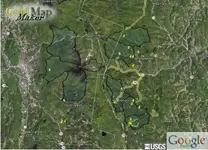
Not a problem at all. Sounds like you are in the killington / Plymouth area. Here is a screen shot of that area out of The Gold Map Maker Library...

P.S. Gold Map Maker is free right now... :occasion14:

Enabled items:
- MRDS gold mines
- Gold history
- River basin segment profiles
- USGS survey data
gmm_sample235.jpg
Gold Map Maker -- The ultimate gold prospecting tool!
 

Last edited:
To Whom it may Concern,

I just received my MacKirk sluice. A word of caution to all who intend upon ordering one for themselves. I ordered an AU trap sluice called the "recon" it looks like a great low water sluice. When you read the dimensions of the sluice on the company website be aware that the demensions are outside measurements. The website said the width was 9 inches across, however the narrowest riffle was 5 inches and they increased in width as you move down the sluice. Dont get me wrong I think the sluice will perform flawlessly, just be carefull that you dont order to small a sluice. I am very happy with the size of my sluice, it should be perfect for what I need it for-small streams. I will let you know how well it worked- next spring.

I too am in the market for a Sluice that is lightweight and better for small streams, Looked at MacKirk products as well as the Le trap out of Canada. Did you consider this sluice at all as it
seems to be fairly well received/reviewed?
Thanks
 

EMassAUMan,
I really liked the design of the LeTrap and feel its a great sluice. The problem is its length, which is over 36 inches. If your sluicing in New Hampshire your sluice has to be less than 36 inches. Do you do any prospecting in Western Mass or Vermont?
 

When I got my MacKirk I was surprised that it was so small. I just recently got a Bazooka to try up in the WMNF the prospector is normally 30 inches but Todd made me one that is 36 inches to meet the forest requirements.
 

Top Member Reactions

Users who are viewing this thread

Back
Top