Lost Spaniard Mine?

airborne1092

Hero Member
Sep 7, 2008
573
373
Inland NW
Detector(s) used
Ace 250
Primary Interest:
All Treasure Hunting
OK -

I wanted to start a reasonable, logical discussion about this place.

Does anyone have any information on this mine? I'm lead to believe it's on the NW shoulder of Mount Adams, near the headwaters of the Lewis River. That would place it in the vicinity of the Pacific Crest Trail where it passes by Adams.

Was this a lost mine, worked by a Spaniard?
Was this a mine, located by accident by a lost Spaniard?
Was this mine found by a Spanish explorer, working in Washington State - like back in the 1700s?
Or, was this a mine found by a Spanish guy in the mid 1800s or early 20th century.

I believe answering these questions will better determine the level of legitimacy for this legend.

Let's get talking - I'm interested!
 

The documentation of this story is weak. Ruby El Hult has a retelling of this story in her book, "Lost Mines and Treasures of the Pacific Northwest." We don't know if the mine was a hard rock, placer, or a pocket.

According to the story, the miner whose name is unknown would travel down the Klickitat Valley on his way to the Dalles. He would cash in his gold at the French & Company Bank. The dates for this story are uncertain but thought to be sometime in the 1880s. It is possible that the mine was actually an Indian mine, located on the Yakima Reservation. The miner disappeared and it is unknown what happened to him. Skeletons of a man and pack animals were found East of Spirit Lake. It could have been what happened to the miner. In 1922, Charlie Wannassie of the Yakima tribe offered to sell the secret of the "Spanish diggings", but it unknown if anyone took him up on the offer. Like a lot of lot mine stories, the quantity of gold is always exaggerated.

A large area around Mt St Helens was obliterated by the May, 1980 volcanic eruption. Millions of tons of ash covered the landscape and changed the topography of the areas around St Helens and Mt Adams. There were places in Eastern Washington where the ash was over a foot deep, and the ash was carried across the entire United States. Rivers and streams in the area were permanently changed. It is my opinion that search for this lost mine is a waste of time.

There are gold veins and pockets in the coastal mountain ranges from Central America to Alaska. The best chances of a new discovery are in areas that have already produced gold in the past. Some of the best areas are already under claim or have been withdrawn by our Government. It is very expensive to develop a hard rock mine, and there is a lot of red tape and compliance. The hobby miner has a much better chance of finding and working a placer deposit. Black sand deposits along the entire length of the Lewis River contain flower gold. The lucky prospector may find some good sized nuggets in the headwaters of the river. Prospecting on the Yakima Reservation is prohibited.
 

I have never told this information about the lost Spaniards mine in the mt Adams area to anyone before. The information I have comes from a relative of a gentleman that researched the location back in the 1930s. There were two individuals involved in locating information about this mine. One was a cousin of a co worker (whom I introduced to prospecting back in the early 70s.) The other partner was a photographer. My friend named Jim was discussing prospecting trips we took with his cousin, who went on to tell Jim of this story. He mentioned that after collecting information from various sources, the two spent a lot of time looking for the location of the mine.They finally ended up on the west side of the Lewis river. Back in the 1930s road N90 only went to the east side of the Lewis river.
They found what they believed to be the proper location of the mine and actually found the opening, and went on about their lives. From the information they collected the following was the key to the location
small creek that had steep sides
the mine was at the top of a water fall not at the bottom as believed.
there was two large flat rocks that were used by the Indians to wash their clothes on
the headwaters held a large aquifer that would expell a large amount of water after a heavy rain to the point of safety while being there.
It was in the mid 70s that Jim and his cousin went on a prospecting trip to the area to retrace the location. I was asked to go but at the time i couldn't make it. I did tell Jim that I would go on the next trip. After driving and using an old map from the 30s Jim's cousin felt that boulder creek a tributary to the Lewis river was the probable location.
Jim's cousin went salmon fishing a couple of weeks later , fell asleep at the wheel and was killed returning home. We were devastated by the accident as the next week the three of us were going back to retrace the location.
I had spent many years prospecting the upper reaches of the Lewis river and boulder creek had the most promising mineralized potential. But there was no gold in the creek. It was from my own research that the gold might have came from straight creek which is a tributary to quartz creek. There is evidence of diggings said to be from Indians and later from a mining coop out of Tacoma washington in the 30s called the plamondon Indian mines inc.
 

Here is Mike Higbee's website on Skamania County mines:
http://49ermike.com/skamania_wa.shtml

Here is a Google Earth reference to the Plamondon Prospect:
http://www.minecache.com/showdetails/10047831

The prospectors of long ago were patient and skillful in their activities to locate gold and other minerals. Where gold is not currently found in a creek, it may not be a good indicator. Old water channels and benches sometimes contain more accessible gold than the current streams that contain overburden and mud. Today's prospectors should look for ancient benches and gravel bars above the current stream levels. The finding of rough quartz "float" in stream beds is a good indicator that a quartz lode is near by.

The information available on the "Lost Spaniard Mine" seems to suggest that the miner used placer gold for his purchases. I suspect he was working a placer pocket somewhere on or near Quartz Creek.
 

I hiked to the Plamondon mine/prospect last summer. It's pretty easy to find. I spent a couple of hours checking things out near the entrance with my metal detector. Didn't go inside as I didn't want to end up having the thing cave in on me. It didn't look that promising as a source of gold, and I doubt that it has anything to do with the Lost Spaniard mine.

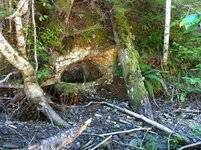
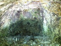
Here's a picture of the entrance. It only goes in 10-12 feet.
 

Attachments

  • IMG_0568.JPG
    IMG_0568.JPG
    109.4 KB · Views: 2,610
The lost Spaniards mine was hard rock and behind a waterfall which could be why you say he paid with placer gold if the vein was being hit by the waterfall then thers would be a glory whole of placer gold along witb his hard rock
 

hi big bear
I have been to the location as shown in your picture. I am going back there jun3 to take samples of the rock. What is unique about this geology is its
similarity to gold deposits in virginia.The gold would not be in the peebles but in the cementing mix that holds the peebles together. Especially if the cement is black.
This location probably was not the plamondon diggings as in the records at the skamania court house show they worked outcrops on straight creek. If you visit straight creek you will find it well mineralized. I still have a portland state university geological and mineralogical survey done in the 80s from straight creek. I would be willing to share that information with those who are interested .But the gold content is low to nill. This is why I believe the real opportunity exists further up the lewis from this point. I have panned quartz creek above french creek and have not found any colors. It was frustrating because there is abundant gold over the divide into yellowjacket creek area.
Then we go to boulder creek further up the lewis and there is mineralization above the falls but again no gold. There appears to be more calcite in this area which indicates a lower temperature intrusion.
The most nteresting find from my experience is in two different locations one above twin falls along road n90 and on alex creek next to quartz creek. At these two location approx 15 miles apart i found float of copper carbonate silicified into a flint like quartz. I still have these in my possession for keepsake.
I hope this information helps develop some more input into this area.
In closing i wonder if the spainard found his gold in yellowjacket creek and everyone during that time thought it came from the lewis area? There were some rich gravels along the creeks in that region.
 

those who are interested in this thread I made it back to quartz creek june 3 2012 and hiked up to the plamondon opening. There is some slight oxidation in the volcanic flow rock along with some fractures. There is no quartz associated with this location or any metallic mineralization. With all of the rain dumping into the area at this particular time I could not hike up quartz creek to further investagate any probable locations.
I did go to the skamania county court house and study the history of that area. It appears that most of the exploration was by an association from the tacoma washington area(olympia). There were a large group of individuals that thought they had found something of value due to the lenght of time they were up there. from 1937 to 1950. After that time all traces of interest dissappeared. After many years of absence from the area when I returned to straight creek I was astonded that I was unable to remember the terrain. It looked so different that I remember. From this I can understand how a small opening in a bank can become lost.
 

I hiked to the Plamondon mine/prospect last summer. It's pretty easy to find. I spent a couple of hours checking things out near the entrance with my metal detector. Didn't go inside as I didn't want to end up having the thing cave in on me. It didn't look that promising as a source of gold, and I doubt that it has anything to do with the Lost Spaniard mine.

Here's a picture of the entrance. It only goes in 10-12 feet.

I was hunting in this area in November and looked for the Plamondon Mine. The only GPS coordinates I could find show the mine up the hill quite away from the creek so I didn't find it.
By the looks of the picture, it's down near the creek. Is it on Straight Creek or Quartz Creek? I've also searched the coordinates of Plamondon Prospect, across and downstream from the mine location and never found anything except Chantrell mushrooms. There are many other mines in the area, and I've looked for the Williams mine, which according to the Lat/Lon is right next to the road.

One interesting thing I've found in the gravel of Quartz Creek was what I think might be small bits of coal, it burned with the smell of oil. I've panned both Quartz Creek and one of the tributaries of McCoy creek without getting any color, but I'll keep looking.
 

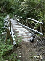
The mine opening that is in the photo is down by Quartz Creek. You have to go down to Quartz Creek immediately after the trail crosses a small tributary creek (Platinum Creek, I think). There's actually a bit of a trail, and its probably no more than 15 or 20 yards down to the creek from the main hiking trail and bridge across Platinum Creek. The photo below is the bridge that crosses Platinum Creek.

IMG_0585.JPG

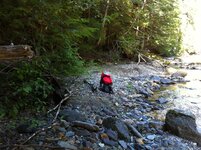
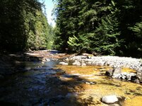
Once you get down to the Quartz Creek, turn left and go up the creek a few yards.

Here are a couple of photos looking up Quartz Creek. The mine opening is on your left as you're looking up Quartz Creek (to the left of where the red backpack is).

IMG_0562.JPG

IMG_0566.JPG

Here's a photo taken from the entrance.

IMG_0577.JPG

I haven't been back since I took these photos.
 

Anyone going up this year? Maybe that old mine might be worth checking around!!
 

lost Spaniard mine interesting comparison

OK -

I wanted to start a reasonable, logical discussion about this place.

Does anyone have any information on this mine? I'm lead to believe it's on the NW shoulder of Mount Adams, near the headwaters of the Lewis River. That would place it in the vicinity of the Pacific Crest Trail where it passes by Adams.

Was this a lost mine, worked by a Spaniard?
Was this a mine, located by accident by a lost Spaniard?
Was this mine found by a Spanish explorer, working in Washington State - like back in the 1700s?
Or, was this a mine found by a Spanish guy in the mid 1800s or early 20th century.

I believe answering these questions will better determine the level of legitimacy for this legend.

Let's get talking - I'm interested!


located in the headwaters of Mc coy creek north of quartz creek was/is a mine called the primary gold mine. The country rocks are similar to those of the quartz creek drainage. What makes this interesting is most of the gold produced was found in the iron oxide joints and seams adjacent to the quartz. Some masses of gold were found in these seams.
I recently visited a mine in Susanville Oregon that produced some rich pockets where the gold was in small masses. The gold was found in iron oxide(ochre) seams with the best value in the parts that were blackened by manganese and possibly some graphite.
The Williams mine on the white Salmon River was found along a cliff where there was no occurrence of quartz. There was iron oxide joints in the short audit. There is some pyrite showings in the audit.
Some rich gold occurrences were found just south of Canyon City Oregon. The great Northern mine was one of them. The gold was found in stringers which were adjacent to the quartz vein and in places crossing it. The gold was associated with the iron oxide and the calcite more so than the quartz.
Now how does all of this relate to the lost Spaniard mine? My theory is that the lost Spaniard found a location where there is a porphyry type of igneous rock that has strong seams of iron oxides. I believe every one was looking for the big quartz vein. I have never had a good assay from a quartz vein from the Lewis river drainage including quartz creek. I have seen some very rusty rock types along with some calcite but never paid much attention to it.
. Years ago I called the Yakama Indian tribe and talked to an elder. He was very kind and answered my questions. He mentioned the fact that the Indians had knowledge of gold occurrences along the nw side of mount Adams east of council bluff. The Frenchman and the Spaniard both knew of the location. A photographer for National geographic magazine was sure he found it in 1934. Does the mine really exist I believe it does.
 

Thanks Big Bear - I didnt get down there this year during Elk Season, but I'll remember and try again next fall or this summer. I've crossed the bridge in the picture many times, so I'll take a closer look. I believe that is Plomodon Prospect though, correct? The coordinates for the Plomodon Mine would be up the hill from there.
 

I might, back in 1979. We heard about the lost Spaniard mine, potentially at ape canyon off Mt St Helens. That summer, we would fly my little airplane around St Helens looking for a potential "waterfall hidden cave." When we thought we found a potential site. We would drop bags of flour to mark where we would need to hike to. It was late September maybe October. The waterfall was dry at the time. We would climb down to this cave, maybe 5 to 7 feet deep. Took some rock samples, you could see the gold flakes simmer in the rock. Had them essayed. And sure enough test came back positive for gold. And you know what happened May 18th 1980. That was the end of our treasure hunting.
 

I would like to see if there is any new interest in this thread? I've been looking in the area and finding some interesting geology.
 

I would like to see if there is any new interest in this thread? I've been looking in the area and finding some interesting geology.

I was just there - Elk hunting - and took a day off to look for the mine. I did not find the mine as pictured.

The bridge over Platinum creek is out now and the water was too high to attempt a crossing.

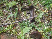
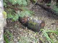
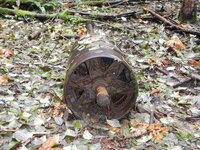
What I did find was the location of the mine compressor apparatus.

DSCN0635.JPGDSCN0638.JPGDSCN0631.JPGDSCN0639.JPGDSCN0640.JPG

This is located just about 100 yards before the Platinum Creek crossing and up hill a bit. LAT/LON coordinates N46.19954 W121.83389 From my GPS... A little off when you look at them on Google earth. Google earth shows them at 46°11'43.16"N 121°49'40.89"W.
 

Last edited:
I'm interestad

I would like to see if there is any new interest in this thread? I've been looking in the area and finding some interesting geology.

I just found this thread and am interested. Been looking at local treasure sites for a while now and decided to join the forum. I only know what I have read but would love to take a trip and learn more. I can buy a good metal detector and own a 4X4 if necessary. I have some hills in Yakima County that I have scouted and found traces of old living establishments but never anything more than old bottles.... I can be reached at [email protected] and have access to means if necessary.

Thanks
 

lost spaniard mine,
the headwaters of the lewis river in the wilderness area of mt adams there is a deep canyon that flows the lewis river. close to the top south of the canyon are several grassy meadows. north of the canyon is lava beds. just up hill of the lave beds in line of the most upper meadow on the north side of the canyon is a very very old log cabin about 12'x12' still standing as of 2008 my guess is the mine is some whers close to that cabin. cabin is about 200 yards from canyon. cabin is very hard to find on flat ground in old growth. i have paned the headwaters of the lewis river and there is gold there. I have never heard of your story before but now i am intrested. One of the orig. settelers of trout lake is Hallenbeck family they lived off gold from mt adams. Want to know more. about that area just ask.


Anyone going up please let me know. I have a nice gold detector. I also have a friend that knows that area well and knows of a abandoned cabin.
 

DeepGold my daughter wants me to take her to this area in search of the cabin this summer. I don't know the area and another set of eyes would never hurt.
 

Top Member Reactions

Users who are viewing this thread

Back
Top