Lost City of Paititi....................The greatest treasure hunt of our lifetime.

Is Paititi a myth?


In 1532, Francisco Pizarro took the Incan King, Atahualpa, hostage and demanded a ransom of gold that would fill a room 24' long by 18' wide and a height of 8', and double that amount in silver. In 1533, fearing an attack by the king's army, he executed the King. Unbeknownst to him, the army he seen was led by Inca General Ruminahui, who was transporting 750 tons of gold to pay the ransom (DOH!). Upon hearing the king was murdered, General Ruminahui hid the gold in a "cave" deep in the Llanganatis Mountains. So...........where did the Incans acquire over 750 tons of gold? There are very rich deposits in Ecuador and Peru, but none producing that volume.

On a different topic, one version of the legend says the Incan god, Viracocha, is living in an underground city with his army, and will one day come out of the city and rebuild his empire.

And lastly, Jesuit Priest, Andrés López, mentioned three German miners towards the end of the letter to the Vatican, which is not unusual because it is well known Spain relied on German mining engineers in the New World.

Is Paititi a myth? My personal theory is Paititi is very real. However, it is not a "city"...........It is a massive underground gold mine.

Gidday Amigo

In all my time and Crow's time drilling all over Ecuador, Peru and Bolivia. Most ancient hard rock mining sites that involved tunnels was colonial Spanish. Most of precolonial gold working by Incas and other tribes.was working placer deposits along rivers.

Here is one such site along the Sacambaya River in Bolivia, and also streams around lap Paz and San Gaban just a name a few.It was a very primitive methods animal skins stretched over a frame and the gold was crudely sifted through. All streams flowing east rule of thumb showed traces of gold amigo. As well as other metals.

Kanacki


As mentioned before, Inca General Ruminahui was transporting 750 tons of gold to pay a ransom. However, after the king was murdered, General Ruminahui hid the gold in a "cave" deep in the Llanganatis Mountains. As for Paititi, that would also be Incan.

750 tons of placer gold means there are mega veins somewhere up stream. Has anyone located the source of the placer?

Gidday Phil

Yanacocha (Cajamarca Quechua: yana "black, dark", qucha "lake, puddle, pond, lagoon")is a gold mine in the Cajamarca region of the Northern Highlands.Considered to be the fourth largest gold mine in the world, it produced 0.97 million ounces of gold in 2014.

The 251-square kilometer open pit mine is situated about 30 kilometers (14 km straight line) north of Cajamarca, in high pampa, straddling the watershed. The operation is a joint venture between Newmont Goldcorp (51.35% ownership), Compañia de Minas Buenaventura (43.65%) and the International Finance Corporation (5%).

The company we worked for was contracted by Newmont Goldcorp in exploration drilling along outer edges of the main mining areas.

Production began in 1993. By 2010, 20 hard rock deposits and 2 gravel alluvial fan deposits were being developed. The gold deposits are located in Miocene to Pliocene volcanic andesite host rocks.

Crow
 

this is a very interesting topic! I would gladly go with you on this search! there is definitely something else there, we could not find everything
 

Gidday Phil

Yanacocha (Cajamarca Quechua: yana "black, dark", qucha "lake, puddle, pond, lagoon")is a gold mine in the Cajamarca region of the Northern Highlands.Considered to be the fourth largest gold mine in the world, it produced 0.97 million ounces of gold in 2014.

The 251-square kilometer open pit mine is situated about 30 kilometers (14 km straight line) north of Cajamarca, in high pampa, straddling the watershed. The operation is a joint venture between Newmont Goldcorp (51.35% ownership), Compañia de Minas Buenaventura (43.65%) and the International Finance Corporation (5%).

The company we worked for was contracted by Newmont Goldcorp in exploration drilling along outer edges of the main mining areas.

Production began in 1993. By 2010, 20 hard rock deposits and 2 gravel alluvial fan deposits were being developed. The gold deposits are located in Miocene to Pliocene volcanic andesite host rocks.

Crow


That was their bad year. 3.3 million ounces in 2005. Impressive by any standard.

You and Kanacki know the area. Are there any undeveloped/unexplored deposits worth looking at?
 

That was their bad year. 3.3 million ounces in 2005. Impressive by any standard.

You and Kanacki know the area. Are there any undeveloped/unexplored deposits worth looking at?

Gidday Phil

Pretty much altoplano is tied up in mining leases. however descending the Andes into the Amazon there are illegal miners working the rivers and old gravel beds. Very rough and cut throat there amigo.

There is a legendary gold mine "Tres Torteas" in Bolivia and many abandoned colonial Spanish working along the San Gaban river. Some workings was abandoned because of an Indian uprising.

Crow


Peru is cracking down on illegal miners, and encouraging large scale mining investment. Granted, it takes 4-5 years to get a permit, but if the ground is worth it...........
 

Peru is cracking down on illegal miners, and encouraging large scale mining investment. Granted, it takes 4-5 years to get a permit, but if the ground is worth it...........

Opportunities Peru is a global mining powerhouse, ranking third in global copper production, second for silver and sixth for gold. More than 14 per cent of Peruvian territory is concessioned for mining, with only 1.34 per cent of the area being used for exploration and exploitation.

Crow
 

Hola phil

For most junior mining firms, the goal is not to bring their project to production, but to advance it to a stage in which it becomes an attractive take-over target for a major mining firm. In April 2015 Rio Alto Mining, which had successfully developed the La Arena and Shahuindo gold projects in Peru, was subject to a friendly take-over by Tahoe Resources in a deal that valued the former at $1.3bn.

But for Average Joe blow bucket and spade miner forget it. Those days are gone like the California 49ers.

Bolivia, Ecuador, Peru, Columbia has had being in conflict with smart artisanal miners since at least 2010. Because all of these countries have sold concessions to junior exploration companies or major mining companies

Kanacki
 

Last edited:
Hola amigo Kanacki,

Yes, I know just about all of those "Paititi seekers" that have done something, or written something, concerning The Quest, and have known Thierry since he first contacted me in 1995, as well as met him a couple/few times over the years in Cusco. On pages 140/141 of his book "PUSHARO...", is presented a little something I wrote concerning my view of the increasingly famous petroglyph site.

Muchos saludos,
Greg
[email protected]
 

Hola amigo Megantoni

My apologies I have a question about Thierry? That you may not be able to answer? Why did he after looking for Paititi then switch to searching Machu Picchu for an underground chamber?

On May 22, 2012, Jamin submitted a new project proposal to the Ministry of Culture to open the door. In November 2012, the regional Direction of Culture of Cusco denied the authorization to excavate the site and, in February 2013, strongly criticized, along with the Direction of Machu Picchu Archaeological Park, the lack of scientism and methodology of his project and assumptions.

But as you can see he left himself open to criticism by archeologists by having a member of his team using divining rods ( at 825)


Kanacki
 

Last edited:
Gidday Phil

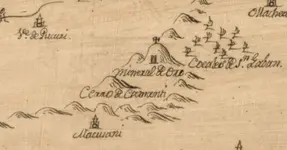
The following parchment is part of 1780 map of the area under control of an Indian uprising against the Spanish.

SAN GABAN MINES.JPG

San Gaban was very productive gold mines in their time.

Crow
 

Gidday amigos

In the National Archives in Sucre for the colonial period from 1765 to 1820 there are over 200 uncataloged manuscripts on Mojos and 41 volumes of cataloged manuscripts on Mojos and Chiquitos in the Rene-Moreno collection. Most of this material is on administrative matters, but there is some commercial information.

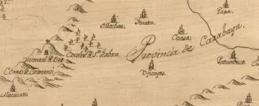
Padre Agustin Zapata in 1695 describing his journey north to the land of Cayuvavas. Which at the time was still thought to be that of Legendary Paititi?

san gaban cayabaya.JPG

Is the Provence of Cazabaya recorded on this 1780 map is the land of Cayuvavas mentioned by Padre Agustin Zapata in 1695 ? Over 85 year a different linguistic spelling version of the spoken name appeared?


Carabaya Province is modern spelling for a province of the Puno Region in the southern part of Peru. It is bounded on the north by the Madre de Dios Region, on the east by the Sandia Province, on the south by the provinces of Azángaro, Melgar and Putina and on the west by the Cusco Region.

If so proximity of San Gaban could of been the source of gold?

Crow


Last edited:
I should also note

In 1693 Padre Agustin Zapata visited the Canichana villages along the Mamore and was told that there were numerous people further down river called the Cayuvava. Zapata visited the Cayuvava the same year trading knives, axes, and machetes for peanuts, maize, and manioc. He reported seeing seven villages, averaging 1,800 people each, ruled by one chief who was bearded and called Paititi. In 1695 he entered one large village that had a plaza, streets, and a temple; people were dressed with feathers and maniaI a big fire was burning day and night; and sacrifices were made of deer, rabbits, and birds (Eguiluz, 1884:336 )

Crow
 

".......ruled by one chief who was bearded and called Paititi."

Very interesting. I have more research to do. Thank you
 

".......ruled by one chief who was bearded and called Paititi."

Very interesting. I have more research to do. Thank you

Gidday amigo

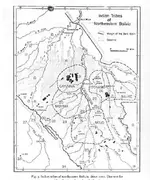
Here is an interesting map of territories of the tribes. However linguistic place names belonging such present day tribes suggest tribal areas in the past was in different locations.

mojo tribe map of bolivia.JPG

Crow
 

Gidday amigo

Here is an interesting map of territories of the tribes. However linguistic place names belonging such present day tribes suggest tribal areas in the past was in different locations.

View attachment 1904758

Crow


The river system to the left (West) of Cayuvava, looks like the Beni River, which would put it in the old Paraguay (Jesuit Paraguay). Interestingly, it would also put it roughly 10 days ride from Cuzco as described by Father Lopez.

Please tell me Paititi was not an old white dude living in the jungle. LOL!
 

Hola Phil amigo

There is an old archeological saying in Peru. From east to west. "Wood, Stone, Clay"

Peruvian amazon buildings was made of wood, On high altplano the Inca built of stone. On the west coast of Peru cultures made cities of Mudbrick. Reason that was the most material; available in each respective region.

You will notice in all of the accounts as far as I can recall there is no mention of a stone city?

Kanacki
 

The river system to the left (West) of Cayuvava, looks like the Beni River, which would put it in the old Paraguay (Jesuit Paraguay). Interestingly, it would also put it roughly 10 days ride from Cuzco as described by Father Lopez.

Please tell me Paititi was not an old white dude living in the jungle. LOL!

Gidday Phil

In our travels in Bolivia We met an old bearded white dude who looked like a scruffier version of Gandaff. He was a practicing sharman. To me he looked like an old hippy anarchist from the 1960's that had taken one acid too many. He told me he was from San Francisco and he had fled down south America in the early 70's. He wore only handmade clothes and ate only native food and to medicines from the Forrest.

I found him a little too "out there" but he seemed happy in himself?

Such is the people you can come across in the extrodinary of places.

Crow
 

Hola Phil amigo

There is an old archeological saying in Peru. From east to west. "Wood, Stone, Clay"

Peruvian amazon buildings was made of wood, On high altplano the Inca built of stone. On the west coast of Peru cultures made cities of Mudbrick. Reason that was the most material; available in each respective region.

You will notice in all of the accounts as far as I can recall there is no mention of a stone city?

Kanacki


Is it because of material in each region, or rather, because the Incans were dispersed after Spanish Conquistadors arrived,and thus, were less organized when they built on the coasts and jungles?

In other words, they had a remarkable knowledge of working with stone, as well as engineering, and they built amazing structures that are still standing today. Those structures are primarily located in the Sacred Valley, which was occupied during the peak of the empire. Yet, on the coast, they used mudbrick, which seems odd considering their skill working with stone.

Have the ruins on the coasts and jungles been dated to a general time frame?

Or perhaps the different building techniques reflected the mindset of the person in charge of each region?
 

Top Member Reactions

Users who are viewing this thread

Back
Top