Lassetters Lost Gold Reef

:laughing7: :laughing7: :headbang:

That's a good one!

There's a long held story here about "manufactured nuggets".

Those who worked in the large Kalgoorlie underground mines (before they became the worlds largest super pit) would every day wear Brylcream in their hair (a brand of hair gel for men popular back before the 70's) & ensure some little bit of gold dudt went home each day any way they could - some in their hair, socks, lunch box, clothes, thermos.

A little bit of gold everyday over a lot of years grows very quickly!

BUT

Also in Kalgoorlie, was the "Gold Stealing Squad" of the WA Police -

How to explain having a large amount of gold - after 30 years or more of working for the mine?

These miners would have gold traps on the plumbing drains from their showers and washing machines - to collect the gold from their clothes washing and showers where they washed the gold dust out of clothes and out of the gel in their hair with strong soap at bath time.

They would each accumulate quite a lot of gold over a long lifetime in the mines - BUT - if they suddently apeared at retirement time with a lot of Gold unexplained - the Golds Stealing squad would be investigating if it was depisitied in their bank for example.

Then in the early 1970's - invention of the "gold detectors" machines.

Suddenly these retired gold mine workers are out in the goldfield and looking for gold nuggets & finding them!

Typical stories were - "I was traveling to the gold fields and we stopped at the side of the road, to relieve our bladder! I decided to try out my new gold finder and after only 3 steps I got a big signal and dug up a 2 kilo hand of faith nugget!"

These photos & stories would show up in the newspaper of old guys with giant nuggets happened quite a LOT - everyone in the 70's was in on the new gold rush with the whites and garretts gold seekers.

What was really happening in many cases - the old retired miners with a LOT of hidden stolen gold over their working careers took the opportunity of the new metal detectors to legitimize their stolen gold by melting a big ol nugget right into a hole into the ground and then straight after, dig it out and photo it with their new detector and send the story to the news paper!

Suddenly - no way for the Gold Stealing squad to prove they didn't just find it in the desert!

A new way to legitimize their stolen gold.

Another story my friend who was a policeman in the Gold Stealing squad for 15 years told me.

A guy has a job at the big Kalgoorlie mine - He drives a truck of ore to the crushing battery there and back a few times every day!
The ore usually around 1 ounce to the tonne - does this for maybe 7 years or more.

In this time, he has his own small "Hobby" mining lease, a small show on a road leading off the main haul route to the crushing battery from the Mine. On weekends off - he has a loader and is blasting and winning ore (low grade) from his lease and stockpiling it!

During the working week on a friday before weekend - he would take the last load and turn off to his lease - tip maybe half the high grade 1 ounce per tonne ore into a pile on his lease, and then quickly top up the truck volume with his loader of his low grade ore, barely worth crushing, and take the half and half load to the battery - and it would be crushed as the mines ore.

No one knew - he did this unchallenged, for maybe 7 years!

Then slowly - he tells people his lease is picking up - maybe he is starting to find a good ore surce and he is carting his stockpiled ore from the big mine and having it crushed & getting 1 once to the tonne!.

Some one came along and sees his crushing records and buys his lease etc based on 1 ounce per tonne for BIG $!

He takes off very wealthy from crushing most of the big mines stolen ore!

The new owner crushes the last of the stockpiled ore and is getting one ounce per tonne - he's happy!

Then he tried crushing ore from the open cut mine slot in the ground and......very very low grade ore, the mine/lease is useless.

It took the gold stealing squad a LONG time to work out how he did it and got away with it!

The big mine didn't even know a little half a truck load a week was missing - because the low grade ore made up the missing volume of ore crushed, they just got back a little less gold each week on a Friday for 7 years!

This is apparently the best way of gold stealing - slowly slowly catchee monkey & no one sees!

Cheers
 

The BIG superstition of Lasseters lost gold mine........

I recently heard a good rumor of what happens to lasseters lost gold mine.

It says that the location was FOUND by US interest in military while using space satellites to search for the lost gold reef.

Suddenly not far south from where Lasseters base camp was and where he claims to have found his fabulously wealthy gold reef, pops up a joint US & Australian secret military base Pine Gap.

Story is gold is flown out direct to US on military craft every week.

australia_map.jpg


thegap.jpg


Yes - its been found and the gold being smuggled out every week by air to the USA!

It funds the underground government and secret flying saucer research - there is no global financial crisis, just a big con job - the underground govt in USA have all Lasseters gold reef $$$$$$$$$$$$$$$

So many covert operations funded from this dollars more than the world can imagine.

Very big conspiracy no one can go there to the top secret base (read mine).

PineGap-sign.jpg


Yeah sure it's defense! :icon_scratch: :icon_scratch:

Steal the big lasseters Gold Reef More likely and right in the spot where he says it was too!

Must think the world is all idiots! ::)

Cheers
 

Haven't posted to this thread in quite a while - 'life' tends to "get in the way" sometimes.
Have been thinking about this topic again today.
I had the opportunity a while ago now to read a very well researched and written book (The Lost White Tribes of Australia) published by one of my fellow countrymen & members here (Thank you Duyfken), which i have to say is a most scholarly and professional work & totally gripping, and in it, was mentioned one specific thing that peaked my interest greatly.

Henry (Duyfken) mentioned words to the effect that, back in the early settlement days of Oz, and prior to - the measurement of latitude was reasonably well mastered... it was longitude that gave them all so much grief and this wasn't eventually sorted until the advent of accurate 'ships chronometers' to allow the reasonably accurate measurement of distance traveled over time period.

Ships navigation - (celestial nav) is a fascinating topic and an extensive one also. Its all pretty much redundant with the advent these days of Sat Nav, however, having passed a 100 tonne ships masters qual I had to learn and practice Navigation with the old manual forms of parallel rules, compass and nautical charts.

So this gives you, a little of an appreciation, of what old time sailors managed to do with limited resources and just how amazing some of their journeys were.

I happened ot live for about a year on an Offshore Island off the West Ozz north west coast, one visited in 1840 by HMS Beagle under command of Wickham and Stokes, and spent time reading their diary /s hips log etc.

Beagle2.jpg


Beagel1Inscription.jpg


They even called in at the above Island (Depuch) next door to ours (West Moore Island) in 1840 (to re-provision the ship with water) and left their "calling card" engraved on a couple of the rocks there...

DepuchIsland1.jpg


So reading such journals - when your actually domicile din the area and can walk in their foot prints and read their inscriptions of the time - sort of brings things clearly into focus!

Anyway in relation to what Henry wrote.. it was about the common practice at the time that Lasseter was around in the 1870's of taking a Known departure point (nearest capital city) as their GMT point for the purpose of discerning longitude and referring to degrees east or west FROM that point, NOT As one familiar with navigation might have done, from GMT (Greenwich)!

I can't thus help wondering having read a fair bit about Lasseter's diary and so on, whether many more modern based navigators, haven't completely mis-read/mis understood his locations distances and bearings.
As you've seen in this thread I've given exact GPS co-ords from Google Earth of the Iilpili Spring/soak where they had one of their last base camps.

Lasetter was only 2 days camel ride south west from that camp, supposedly when locating his Eldorado, now 'lost' reef.

But What I am left wondering i guess is if one were to go back and research his original notes and all that is known and apply say his longitude references as based from say either Adelaide whence his well financed / resourced trip originated, or even Alice Springs...

Would this maybe substantially "alter" any the actual location of his purported find?

i.e are people interpreting his distances (nautical miles = 1.18 statute miles) and also his bearings from say magnetic north, rather than true north etc, incorrectly?

It's mentioned in the "story" linked above, about him walking to Carnarvon on the West Coast - that they took bearings using their watches, and upon arrival at Carnarvon were "surprised" that both watches were well "out" by some hours and thus any bearings would be incorrect by that margin....?

But likely this is not the case at all.

Where they departed from (Either Adelaide or Alice Springs) are well EAST of Carnarvon & thus in a different 'time zone'.
Today if you flew from Adelaide to Perth, on a commercial Jet - you'd set your watch back or WA Time Zone by 1.5 hours or whatever.
If you walked that same / similar distance - then when you "arrived" at the West Coast in Carnarvon - then yes they would all have their clocks 1.5 hours different to the watches the 2 men were wearing!.

So I guess what I am saying is - that it should be easy enough to work out from the actual historical record, of Lasseters diary and bearings, distances etc - pretty much were he actually was within a couple days camel ride. (So probably within 40 odd miles and we do happen to know where his base camp was at Ilpilla Soak to today's accurate GPS coordinates.

Of course big mining company's have certainly done huge amounts of magnetometer work looking for gold in this area - the facts are it's within the Yilgarn Craton which is a known major auriferous zone in Australia and POSSIBLY the longitude readings Lasseter gave, were based on a meridian running thru either Adelaide or Alice Springs itself as zero meridian.

What i am suggesting is this "work" doesn't actually NEED an expedition - its basic desk top research.... do the math with whats already known, historically and physically on the ground - and the modern new tools like Google earth to try and confirm and calculated position.

If there's any sort of 'north - south' 10 mile long 'reef' type structure visible THEN look at mounting an expedition to go sample it.

As others have said - he didn't get samples containing gold at decent amounts near 3 or 4 ounces to the tonne unless he had a good show to collect them from.

OMMV of course - there are many who spend a great deal of time trying to debunk Lasseter.

Hard physical samples are hard to debunk IMHO.
 

Last edited:
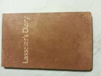
Hi Eddie, with all the research you have done, I guess you have already read this : 2015-05-13 17.01.10.jpg
 

Actually No I haven't read his physical diary at all Mike - thanks heaps for posting up the photo!. I didn't know (and still don't) know where the original exists these days (A museum/library I am guessing?).

I have read various 'excerpts' quoted from it tho - that have been posted by some who were "interested" in the topic at a few Aussie and West Aussie prospecting web forums!.

And thats always frustrated me a great deal - because I do like to research things thoroughly and sometimes having "snippets" of the real thing is more frustrating than reading the real thing in its entirety because of whats NOT included in the snippets & THAT then leaves one desperate for more!.

One of the problems is that sometimes people post excerpts that suit their belief system or agenda and the quoting can be selective to support their supposition/s.

As I learned from reading Wickham and Stokes logs from their trip past the Island i lived on for a year - sometimes you have to read the whole thing (more than once) in order to get the proper context & you also have to interpret the thing in relation to the time it was written also!.

I would give my left ball to be able to read all of Lasseters Diary at my leisure and in full & to make notes etc.

Dyfken will know what I am saying here... he is a researcher par excellence.. having read his latest book about the Lost White Tribes of Australia Chronicling the fate f the dutch sailors shipwrecked on our coast from the 1600's onwards.

Like I said - it was his comment about using the nearest major city as Zero meridian for longitude - that made me do a double take about what I can remember of what I have read, in the snippets quoted online, from his diary over the years.

And this is crucial to understanding what is written - interpretation based on the history at the time... the social mores etc are probably very critical to correct interpretation.

Many things when written aren't mentioned specifically because they are taken as a given (everyone of the time knew them, so there was no need to mention it specifically). Maybe everyone of the time KNEW that his determined positions with the Surveyor partner (Harding?) were from a Adelaide (or Alice Springs?) zero meridian?

Maybe its oly later navigators who have overlooked this histrocal aspect and ascribed a much later Greenwich mean time Zero Meridian?

Is this why so many attempts to relocate his reef have failed?

Let me see if I can give an example of the need for understanding the traditions in existence at the time in interpreting a narrative.

I did some reading once of a theological nature, bye an anglican priest (Johnathon Selby Spong) who authored a basicaslly theological book called "Born of a Woman" about the life & times of Christ, re - interpreted in the Jewish period of 2000 years ago!.

Many are probably familiar with the basic story.

We know for e.g. that he went to a wedding in Cana and performed his first miracle there, turning water to wine.

We know that He raised Lazarus from the dead.

We know that he too was placed into a tomb in the Garden of Gethsemane, that belonged to one Joseph of Arimathea from which he was also raised.

We know that John The Baptist was beheaded at Herod's wife's insistence.

We know that Mary Magdelaine was "a disciple" of Christs (The one he was described as loving more than all the others in the Gospel of Thomas found in the dead sea & Nag Hammadi scrolls for e.g.).

We know that Mary Mother of Jesus (Jospeph's wife) went to visit with her cousin 'Elizabeth' while herself newly pregnant with Christ - when Elizabeth herself was already 6 months pregnant with John the Baptist.

So Jesus and John the Baptist were about 6 months apart in their ages & were "related" by virtue of their mothers being first cousins.

But.

How many are aware of the Jewish custom of 2000+ years ago... that if a man who is married dies, without issue (children) that his brother then "takes in" the widowed wife, as his own wife and that any "issue" (children) are considered the children of the deceased male relative?. And of there is no brother then the responsibility falls to cousins.

If you research it as author Shelby Spong did - you will find that in all likelihood Mary Magdelain was John the Baptists wife and that when John The Baptist was beheaded without issue that Jesus his cousin 'married' her at the wedding in Cana!.

It also seems that She had issue fathered by JC - (named in the bible as "jesus barabbas" literally "son of the rabbi Jesus" in the old hebrew) BUT importantly considered to be the male offspring of John The Baptist under Jewish custom of the time!.

Many other things make sense when you realize these familial relationships.

Mary Magdelaine, was the daughter of Jospeph Of Arimathea.
Lazarus was the Son of Joseph of Arimathea!

Thus Jospeh of Armimathea was by default - JC's father in law after the wedding to Mary Magdelain in Cana!

Is this not why Joseph of Arimathea was able to go to Herod and get JC's body down off the cross for passover, an dplaced it in his own tomb in the garden of Gethsemanie?

Did not JC raise Lazarus because he was his brother in law & his wife Mary Magdelaine (Lazarus sister) insisted?

Who provides the wine at a wedding? The groome!. Who turned the water int wine at his wedding in Cana to Mary Magdelain, his cuzzin John The Baptists widowed wife? Thus JC was the groom!

Who instructs JC to do something about the wine running out? His mother... Mary wife of Joseph!. What is her public "role" under jewish custom at this wedding? Mother of the groom she is the "hostess" of the wedding feast.

No Jewish woman under their custom 2000+ years ago could tell a grown Male (Much less "the teacher" which translates as rabbi / raboni) what to do in public.. UNLESS he is "the groom", and "she is the hostess of the wedding" because then it IS his responsibility to furnish the drinks for the wedding - which he then does (by performing his first documented miracle of turning water to wine!).

Many things about the JC narrative make complete sense when interpreted in accordance with the historical context of the time.

I have a suspicion that much about "Lassetters Diary" and the surveying notes therein - could be better understood if they were re-interpreted in accordance with what were the navigational/surveying "norms" of the time in relation to longitude and zero meridian as so aptly pointed out by Duyfkens (Henry's) most excellent research about this 'historical phenomena' in relation to zero meridian common practices of the era published in his book.

I think this could well be "KEY" to re-interpreting the record, in a more modern context!.

Who knows what enlightenment it might yeild?

Could it hurt to try?

Would love to knwo how to get hold of a copy fo his original diary for this specific purpose?.

Intriguing idea to say the least!.
 

LASSETER'S DIARY

Theres indeed a great deal of reading to be had on the matter of Lasseter on line if one is of such a mind.

Some of it places questions about the published record of Lasseter's diary.
 

Thanks heaps Grantler... I shall go invest some reading time - gonna rain solid here for the next 2 days...so a good time to do some homework.
 

I need to go back and re-read that section of Dyfken (Henry's) book - to make sure I quote him correctly! Maybe there's something in his references as to where he found this information?, It might even have MORE data regarding this apparently common practice of using the neatest major city as zero meridian in the late 1800's explorations of Oz?
I might send Henry a link to this thread - maybe it's something he would like to contribute information to - seeing he has researched this aspect thoroughly for his book.
I would hate to get this wrong based just on my memory of reading his book!
You see, there's only about 5 degrees (1 degree = 60 N/miles) so 300 N/miles or 354 miles "difference", east/west between Adelaide (138Deg East) and Alice Springs (133 Deg East).
We know Lassetter camped west of The McDonnel ranges in the Northern Territory at Ilpilla spring as his last base camp (with permanent water).
We know his discovery was somewhere East of the Peterman ranges near the West Australian Border with Northern Territory.
The thing is - what was He using as his zero meridian (With the surveyor Harding)?
Did Harding the surveyor keep any diary / notes that might give us any further clues?
I am just thinking that IF perhaps Harding and Lassetter used Alice Springs (133 east) rather than say Adelaide (138 East) as his zero meridian, then distrances etc could be anything up to say 354 miles further WEST than previously thought maybe?
So to give an example...
Lasseter at some point walked all the way to the West Aussie coast at Carnarvon.... (113 east) presumably from Alice Springs (133 East) in the earlier story posted in this thread where he reported his and hardings watches being "out be a couple hours" (to be expected due to time zone differences).

That's a full 20 Degrees of Longitude (West). 20 Degrees x 60 N/Miles per degree = ~1200 N/miles or 1416 Statute Miles (or ~ 2265 kilometers!). Now that's a hell of a walk! (At least 70 days at ~20 miles a day).

For this guy & his crew (with Camels) a mere 350 miles (west), due to maybe using Alice Springs as his Zero Meridian rather than Adelaide a further 5 degrees East, probably wasn't "a lot" to speak of...here or there!.
It might well have been something that wasn't specifically mentioned because - it was "the norm" for the time - no need to mention it - everyone at the time did it?.

See what Henry has to say I guess?.

Cheers
 

I wrote a piece on this for my shipwrecks and lost treasure page on Facebook... His son, Bob Lasseter , is still looking for it ...1381486_724119207603596_2084530189_n.jpg
Lasseter's Reef ... Australia's Lost Dutchman Mine ...
Lasseter's Reef refers to the purported discovery, announced by Harold Bell Lasseter in 1929 and 1930, of a fabulously rich gold deposit in a remote and desolate corner of central Australia. Lasseter's accounts of the find are conflicting and its precise location remains a mystery—if it exists.
Discovery
In 1929 and again in 1930 Harold Bell Lasseter (1880–1931) made conflicting claims that either in 1911 or in 1897, he had discovered a rich gold deposit.. On 14 October 1929 he wrote a letter to Kalgoorlie federal member, Albert Green, claiming to have discovered "a vast gold bearing reef in Central Australia" 18 years earlier and that it was located at the western edge of the MacDonnell Ranges. He made a similar claim to other officials and was interviewed by a commissioner and a geologist, the government took no action to investigate the claim. It was revealed that from 1908 to 1913 Lasseter lived on a lease-hold farm near Tabulam.
https://www.facebook.com/notes/ship...ustralias-lost-dutchman-mine-/724110894271094
 

I remember hearing a story about Lassitters map being deliberatly made upside down, could throw a whole new slant on things.
 

Duyfken (Henry) got back to me...

No I didn't say that (re capital city zero meridian).

What I did say is that the OLD prime meridian (zero) used to be at Tenerife, an island in the Atlantic coast off Portugal. It was logical to use that point as nobody believed that you could go too much further than point without falling off the edge of the earth.

It was later changed to Greenwich but it took sometime before every country used it.

My memory is obviously playing tricks on me (which is why I wanted Henry's input)!.
 

Hi Lucky,
I'm well acquainted with Lassiter's reef. i know where it approximately is and I was asked to lead an expedition there but it has been a couple of years now since I have heard from them. They needed to raise the capital to go there, prospect etc and return. That's all I can say as I am committed to secrecy except I wish them good luck with or without me.
As far as confusion over navigation goes, you need to know if he was speaking in English land miles of nautical miles. By Lasseter's time they were able to work out pretty accurately where they were. However, it is an extremely dry and unforgiving place. The mind plays tricks, the energy can be completely sapped and your judgement could quite easily become impaired.
 

Just wanted to chime in, 4 years later, that I've been intrigued with the Lasseter story in the last few years. I've been writing a fictional story about its being found in a small Aborigine tribal area, and they have been keeping it secret all these years since it is at one of their sacred locations, and they have been able to keep outsiders out of it. (FICTION, I say!). When a crisis forces their hand and they have to cough up ransom money in a hurry to recover a kidnapped aborigine toddler, they come into town with a box with over a million dollars of gold in it to meet the deadline (The kidnappers know they have gold, and have given them an impossible deadline to make it surface). It all goes awry for the kidnappers when station owners from further south hear of the toddler's loss (before the ransom message is given), and launch a massive ad hoc search effort of the desert with their mustering aircraft. (Kidnappers put her in a cage under a bush with water and food out in the desert, not particularly caring whether she survives or not). One of the searching pilots sees the cage just as he is about to run out of fuel, and just then the search is called off due to the ransom note insisting the planes and helicopters be grounded. The pilot and his daughter are not sure there was anything (or anybody) in the cage...... the little girl is rescued that night by searchers who go out stealthily with the GPS bearings of where the cage was sighted, unknown to the Police, who are following up on a false lead that ends as a trap with two of the officers being shot in the desert a few miles away. They get the toddler back to town, but not before the village elders bring out the strong box. Thankfully, the kidnappers get neither the strongbox, nor the toddler....but the village secret is out. These Aborigines have gold--lots of it--and now it's public knowledge......Fearful that outside forces will strongarm their way into their territory and cut them out of both their sacred land and their gold, they decide to make a village effort to mine the alluvial ASAP. Then they take several million in gold by plane to Kalgoorlie and start setting up bank accounts and legal help......There's more to story, but that's my part about the gold deposit. I haven't finished the book yet.....

One of the young girls in the book, who is partly Aboriginal descent, is a talented child musician. Her brother writes folk songs, and together with their friend, another girl, the three record music videos and upload them on the internet. One of the "original" folk songs they sing is called "The Girl From the Rawlinson Ranges" which is an ironic song about a lady who didn't know how to gently say "no" to a soldier who was interested in her, so she told him to come find her at her home in the Rawlinson Ranges. Unfortunately, he takes her seriously and set outs to find her....as you can imagine if you know anything about the Rawlinson Ranges, that didn't end well for him. She tells him to come find her at her home "in the Rawlinson Ranges, just west of Lasseter's Reef." If he'd been smarter, he would have known she was dismissing him. He thought she meant it..... Anyway, the song propels the kids into serious recognition on the fictional equivalent of You-Tube.....anyway, reading this thread makes me want to get in there and finish the book!
 

Top Member Reactions

Users who are viewing this thread

Back
Top