KY Historical Markers

Mundy had been a captive of the Indians and was suppose to know the area, which would have been a big advantage over an explorer of the area . Mundy was also suppose to known where the silver deposits were from working them. As for 8 to 12 miles a day traveled, figure that to be accurate for a explorer that would be looking at everything around in new territory.
 

Last edited:
Mundy had been a captive of the Indians and was suppose to know the area, which would have been a big advantage over an explorer of the area . Mundy was also suppose to known where the silver deposits were from working them. As for 8 to 12 miles a day traveled, figure that to be accurate for a explorer that would be looking at everything around in new territory.

I think Mundy (an English proper name) being called a Frenchman, represents the French mines that already existed in the story line, I am beginning to think he was not French at all. I think the Spanish opened the mines, used Indian labor and later the French operated the mines prior to Swift working them. This makes more sense as conventional theory says Natives didn't know how to smelt metals at those temperatures. This thought process has no proof obviously, just a theory on my part.
 

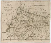
Finally found a good copy of the map of KY that shows 'Reputed Silver Mines' East of the KY river headwaters and West of Paintsville. Many of these maps have been altered online....why? Download if you wish for your own research.

Gilbert Imlay Map KY.jpg
 

Reputed : being such according to reputation or general belief

Seems even in the 1790s there was only general belief that the mines existed.
 

Finally found a good copy of the map of KY that shows 'Reputed Silver Mines' East of the KY river headwaters and West of Paintsville. Many of these maps have been altered online....why? Download if you wish for your own research.

View attachment 1906935

Great score and share, thank you. I followed the link and found his 1797 map which is much improved and omits the silver mines reference. Interesting to note all of the roads and paths. I have never seen the "Road to Virginia" before, that route covered a lot of ground, going thru Mt. Sterling, Olympia Springs (Mud Lick) and Morehead. Interesting route from Mud Lick into Frenchburg and then to the Gorge area.
 

Great score and share, thank you. I followed the link and found his 1797 map which is much improved and omits the silver mines reference. Interesting to note all of the roads and paths. I have never seen the "Road to Virginia" before, that route covered a lot of ground, going thru Mt. Sterling, Olympia Springs (Mud Lick) and Morehead. Interesting route from Mud Lick into Frenchburg and then to the Gorge area.

I wondered about the three circles South of the Red River marked as 'Settlements' too.
 

I don't know if any or many of you have interest in the Col. Harrod aspect to the Swift legend, but he does occupy a major place in KY pioneer history. This was a live feed of a presentation about his contribution to KY history. Interesting what is known of him and differing competing story lines of him...gives some idea of why so much of early KY/US history is not well documented...and may explain why so little is known of Swift?


Top Member Reactions

Users who are viewing this thread

Back
Top