Jesuit Symbols?

Deducer,

Gold could be refined to a very high degree hundreds of years ago as evidenced by some of the gold bars recovered from the Atocha (1622). The bars are marked in Karats from 16 through 23.5.

When I say refined, I don't necessarily mean .9999 pure. By refined, I mean a step beyond Dore.

.........as to where the bars came from...............I have no idea. None of them were marked in any way (according to Willie). Because nobody has found Willie's Cave (that I am aware of), I don't believe anything was added to the mix. In the case of The bars under Victorio Peak, Doc described the amount of bullion he saw. It was FAAAAAAAAAAAAAR less than the "approximately 93 million troy ounces" as described by Capt Orby Swanner. In Doc's Case, I think the government mixed gold from either (or both) recovered plunder from Europe and\or the Pacific by the Axis Powers during WWII.


DIRT1955,

I don't believe so. At least (according to Willie) as of 1998 nobody had found his cave. Doc Noss had a second cave in the Caballos that he showed to Willie at some point. This cave MAY have been found by Fred Drolte in the 1970s. There are reports of Drolte telling all his workers to leave the site one day (the site being The Drolte Hole). Drolte supposedly hauled something out of the hole that night, then paid off his workers handsomely. One of the workers told this story. Can't verify one word of it though. LOL

Mike

Thanks for sharing this fascinating story- if you're able, please share more.

Have you formed an opinion on where the gold came from and who put it there?
 

Not even near the ballpark. There are several historical claims near your spot, but for Willie's Cave, Drolte Hole, Doc's Caballo Cave, you need to be in the area of Burbank Canyon to the North. I promise you will never find it on G.E.

Mike
Not expecting to find it using GE, however, locating areas where natural caves may be formed is possible with GE
 

Not expecting to find it using GE, however, locating areas where natural caves may be formed is possible with GE


Alan,

You REALLY need to talk to some locals about caves there. More stories than you could shake a stick at. Willie's Cave is not exposed. It is sealed. If it were an open cave it would have been found loooooong ago.

Deducer,

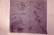
I really couldn't say. One thing for sure; if the two maps are real, and they do fit nicely together, they show two two "Almacens" (counting rooms/warehouses). One look like in the Caballos and one somewhere near the headwaters of the Gila River. The latter being the largest and most important. If the two maps are authentic, they also show that the Caballo Almacen was on the route the gold and silver took from the Sonora Mines of the Jesuit Order. The map shows a mule train would start from "La Sonora" which was run at the time of the map by a Padre Francisco Villegas Garsina y Orosco SJ. The loads from the various mines would intersect with the path of the La Sonora Mule Train at different intervals.
img131.jpg

THIS map shows a Mule Train Trail from Jesuit Sonoran Mines straight to a Counting Room/Warehouse in the Caballo Mountains. If the map is authentic, then it is strong evidence for the bullion found there as being from those mines!

Mike
 

Last edited:
Deducer,

I really couldn't say. One thing for sure; if the two maps are real, and they do fit nicely together, they show two two "Almacens" (counting rooms/warehouses). One look like in the Caballos and one somewhere near the headwaters of the Gila River. The latter being the largest and most important. If the two maps are authentic, they also show that the Caballo Almacen was on the route the gold and silver took from the Sonora Mines of the Jesuit Order. The map shows a mule train would start from "La Sonora" which was run at the time of the map by a Padre Francisco Villegas Garsina y Orosco SJ. The loads from the various mines would intersect with the path of the La Sonora Mule Train at different intervals.
View attachment 1734515

THIS map shows a Mule Train Trail from Jesuit Sonoran Mines straight to a Counting Room/Warehouse in the Caballo Mountains. If the map is authentic, then it is strong evidence for the bullion found there as being from those mines!

Mike

Mike,

You mentioned two maps.

Does your other map contain the phrase "Anno Mariano" at the bottom?

If so, I agree that those two maps are very much related, and are real- but that the map you posted (or rather NP) is a hand-drawn copy of another map.
 

Deducer,

I really couldn't say. One thing for sure; if the two maps are real, and they do fit nicely together, they show two two "Almacens" (counting rooms/warehouses). One look like in the Caballos and one somewhere near the headwaters of the Gila River. The latter being the largest and most important. If the two maps are authentic, they also show that the Caballo Almacen was on the route the gold and silver took from the Sonora Mines of the Jesuit Order. The map shows a mule train would start from "La Sonora" which was run at the time of the map by a Padre Francisco Villegas Garsina y Orosco SJ. The loads from the various mines would intersect with the path of the La Sonora Mule Train at different intervals.
View attachment 1734515

THIS map shows a Mule Train Trail from Jesuit Sonoran Mines straight to a Counting Room/Warehouse in the Caballo Mountains. If the map is authentic, then it is strong evidence for the bullion found there as being from those mines!

Mike

That map appears to be a sort of summary chart similar to the more detailed "MLCXVI ANNO MARIANO" map (I won't post that map - don't ask), which essentially shows the same information and much, much more. The provenance of both maps is unknown, but it's my working model that the information contained on them far predate the Jesuits, and the 16th Century too for that matter.

The Jesuits may have somehow had access to this original map information and possibly re-discovered old mines in the Sonora region based on their intel. I don't believe the Jesuits ever ventured into the Caballos (through Apache territory), as New Mexico had been granted by Papal Bull to the Franciscans and was clearly under their control at the time. However, it does bring to mind the unsubstantiated rumors that Kino may have made covert reconnaissance missions into, say, the Gila headwaters region.

Bottom line: it seems plausible there is a solid link between the Gila headwaters region and the Caballos that predates the Spanish Conquest.
 

Mike,

You mentioned two maps.

Does your other map contain the phrase "Anno Mariano" at the bottom?

If so, I agree that those two maps are very much related, and are real- but that the map you posted (or rather NP) is a hand-drawn copy of another map.


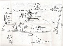
No, the other map is not the Anno Mariano. It is the map Willie Douthitt used to find his cave that he got when he killed young Jack Reynolds:

map.jpg

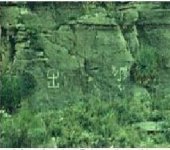
If you orient the map 90° Clockwise, you get a very good representation of the Rio Grande from the curve to past Truth or Consequences. Notice the trail comes from the Southwest right to the mountains? Just like the previous map. One thing that lends credence to Willie's Map is a glyph found in the mountains:

mapmatch1.JPG

If you look closely, you will see that glyph on the map.

Mike
 

No, the other map is not the Anno Mariano. It is the map Willie Douthitt used to find his cave that he got when he killed young Jack Reynolds:

View attachment 1734678

If you orient the map 90° Clockwise, you get a very good representation of the Rio Grande from the curve to past Truth or Consequences. Notice the trail comes from the Southwest right to the mountains? Just like the previous map. One thing that lends credence to Willie's Map is a glyph found in the mountains:

View attachment 1734681

If you look closely, you will see that glyph on the map.

Mike

Very interesting, thanks for sharing.

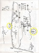
I do agree that the map is meant to be viewed in the way you describe it. I've seen the two symbols circled in yellow below, on another map- accompanied by the words levante and poniente which of course you would know to be the rising of the sun and the setting of it, e.g., a clue to the cardinal directions, East and West- and therefore the proper orientation of the map. I don't want to reveal too many details but there are quite a few similarities between the other maps I've seen and the one you just posted.

Ccopy.jpg
 

I don't believe the Jesuits ever ventured into the Caballos (through Apache territory), as New Mexico had been granted by Papal Bull to the Franciscans and was clearly under their control at the time.

You may want to revisit that premise after reading a little about the Jesuit-Franciscan dispute over territory known today as New Mexico, here.

In May of 1651, the Jesuits were told to stay west of the headwaters of the Bavipse.

I now suspect that the Jesuit practice of sequestering their riches was not something done on the event of expulsion or the expectation of it, but was in fact, something started on day one, from the moment they set foot on New Spain. That is, they already had their game plan by the time they put foot down on terra firma. Let's face it, everyone that set out west for New Spain had visions of gold dancing in their heads. They went there to get rich. Evangelizing was just another excuse to plunder.

So by the time the area known as New Mexico was granted to the Franciscans, I think that the Caballos almacen was something that had already been underway for a very long time.

Yes, there was some friction between the two Orders in the 17th Century, even the alleged intrusion(s) by Kino. However, to the point, an apparently large scale Jesuit gold caching operation smack on the Camino Real de Tierra Adentro at the Caballos, 100 miles north of Paseo del Norte (as speculated by the rumors) is unsupported. If there are true facts underlying the modern "treasure maps" in the region, the origin of the loot remains unidentified, IMO.
 

If you learn how those Ancient store houses are made and marked, you dont need a map. Just drive to any mountain range out here in the south west and you can spot them. They also have been marked by a great group of Treasure hunters from the past. You have the Canadians that seem to have knowledge of those store houses out here. They seem to be trying to work their way into getting at them thru a fake front as wanting to mine for non precious metals. I hope the U.S.A doesn't give them permission. Its kinda interesting that the French got that knowledge. I sure would like to see our Government work with treasure hunters here in the U.S.A. to open those sites.
 

Yes, there was some friction between the two Orders in the 17th Century, even the alleged intrusion(s) by Kino. However, to the point, an apparently large scale Jesuit gold caching operation smack on the Camino Real de Tierra Adentro at the Caballos, 100 miles north of Paseo del Norte (as speculated by the rumors) is unsupported. If there are true facts underlying the modern "treasure maps" in the region, the origin of the loot remains unidentified, IMO.

The Camino Real de Tierra Adentro (CARTA for short) didn't become a busy route until well into the 18th century, long after the Jesuits had gone.

And it isn't as if they used the CARTA, because all three maps show that the routes they took crossed the Rio Grande from a Southwestern direction, from Sonora.

Also don't forget the Pueblo revolt of 1680 which was a huge setback to the Spanish colonizers- and virtually left New Mexico unattended for the next several decades, during which only conductas made the journey north, every three years, to supply the missions and presidios.
 

Man, I need to pack my bags and move to the Southwest before I get too old to be scampering up and down mountains.
 

Dog’s post got me thinking: I read about some of you researching The Spanish Archives for information or clues about these mining operations. It blows my mind that there would still be information detailing the locations of gold and silver mines, storehouses, etc that hasn’t already been exploited by the big boys (billion dollar mining corps, political titans etc)). Surely information like that would be immensely valuable to the people in charge (Royal families, Roman Catholic ecumenical councils) and would be protected through politically turbulent times. If I was a European regent or religious leader and understood that the wealth of America is forever out of reach, I would capitalize on my knowledge and sell that information to the industrial barons or heads of state of 18th/19th century USA.

So where/how did these maps you guys are sharing or alluding to end up in the hands of mere mortals (no offense, lol!) ??
 

Last edited:
Why you guys were busy tapping on your keyboards trying to figure out who did what and were they went and how to get in the storage this company came in and got it.
 

Dog’s post got me thinking: I read about some of you researching The Spanish Archives for information or clues about these mining operations. It blows my mind that there would still be information detailing the locations of gold and silver mines, storehouses, etc that hasn’t already been exploited by the big boys (billion dollar mining corps, political titans etc)). Surely information like that would be immensely valuable to the people in charge (Royal families, Roman Catholic ecumenical councils) and would be protected through politically turbulent times. If I was a European regent or religious leader and understood that the wealth of America is forever out of reach, I would capitalize on my knowledge and sell that information to the industrial barons or heads of state of 18th/19th century USA.

So where/how did these maps you guys are sharing or alluding to end up in the hands of mere mortals (no offense, lol!) ??

It takes money and good connections, including respected academic credentials, to be allowed to research documents in the Seville archives. I've posted the protocols before for those who were interested. Early Spanish sites in the New World and elsewhere can be researched if you have some pretty good info to begin with, since specific documents have to be requested, and I'm sure modern discoveries have been and will be made for the diligent. That said, it's ungodly naive to assume that information leading to fabulous abandoned gold mines is available by browsing in the "Spanish archives." Anyone need an explanation why?

Same goes with treasure maps, as you alluded to. Why would a schmo ever lay eyes on a genuine map? Even if Noss The Grifter somehow came across genuine maps, how did they come to be published into the public domain? I guess we're all fortunate, eh? Or hopelessly gullible.

That said, I was given one of these old maps myself a few years ago, either an obvious modern copy or a hoax of some sort. As with the NP map, I would have dismissed it if it weren't for certain symbols and their alignments, which I found independently during prior decades exploring in certain areas, some of these associations not available anywhere else. Do I "believe" the MLCXVI ANNO MARIANO" map? All I can say for certain is that whoever drew it up was well informed.


I suppose one explanation is that the map bearer met a untimely end at the hands of person(s) with a lust for gold ? Murder and thievery seems to be common factor in these stories.
 

I suppose one explanation is that the map bearer met a untimely end at the hands of person(s) with a lust for gold ? Murder and thievery seems to be common factor in these stories.

That was the case with Willie Douthitt (and his friend Doc Noss).

In the case of the Jesuits, they were hiding their wealth from the Spanish. They knew the Suppression was coming before their arrests in 1767. When arrested, they were only allowed to keep the clothes on their backs, their breviaries, and a copy of Thomas á Kempis' "An Imitation of Christ". If they had tried to smuggle out a map, they would have easily been caught, and their hidden treasures compromised.

HIDDEN treasures were hidden for a reason. The hiders didn't want anybody else to find them!

Mike
 

I agree that they must have had some knowledge of what was coming for them. They would have hidden their wealth away from the missions. I have a theory on where they may have hidden some of it. There are many signs at places where no missions are known to be. Way to much for a trail. Most of these places are at a 12 mile distance from each other. Well that is only tested in my area. Have anyone noticed this out west?
 

For an explanatiom as to where the dore' bars came from, they came fro the Tayopa mines in Chih, Mexico, see NP's lil map.!
They was the storage pts for transference from the nines to Chih. city to the l Paso and then to Victori Peak and the Caballo mt, where they had the holding caves ready for a quick trip -realitively - down the rio del Norte to Matamoros to a waiting jesuit ship for transference to Rome See Oro.
 

Last edited:

Top Member Reactions

Users who are viewing this thread

Back
Top