I've been in the Red Top mine and didn't even know it!

TerryC

Gold Member
Jun 26, 2008
7,786
11,136
Yarnell, AZ
Detector(s) used
Ace 250 (2), Ace 300, Gold Bug 2, Tesoro Cortes, Garrett Sea Hunter, Whites TDI SL SE, Fisher Impulse 8, Minelab Monster 1000, Minelab CTX3030, Falcon MD20, Garrett Pro-pointer, Calvin Bunker digger.
Primary Interest:
Metal Detecting
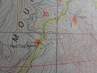
I re-visited Tim, after 5 years. He is a neighbor. I told him the Red Top was just across the road from his home. I asked him for permission. Even though the Murphys topo shows it there, he told me where it REALLY was. I cannot divulge right now. I have been in the RT adit years ago and was unaware it was the RT. On Tim's property are pieces of the machinery once used in the mine. He showed me. The mine was worked until 1933. The adit runs downward at an angle for A MILE under ground! Many of the homes in the immediate area housed the workers (old coins?). How do I know he has good scoop? He is the Murphys Museum (curator?). It is his job to know such things. Incidentally, his wife is the daughter of the man that sold Judy's father this 80.... at 250 an acre, in '55. The family goes WAY back in the area. If there is a message here, ASK for permission. Talk up your passion to everyone and the research potential takes care of itself. ╦╦Ç

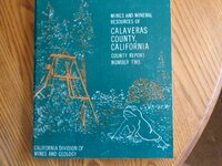
EDIT: That puts ANOTHER error into the Calaveras 1963 paper number two.... don't believe everything you read.
 

Last edited:
Upvote 0
That was QUICK CD. I think you liked before I even added the edit. ╦╦Ç
 

Hello
Just wondering if the mine mite be on maps of the 1950's?
Like the part about asking and the error in the local paper. Thanks
 

Hello
Just wondering if the mine mite be on maps of the 1950's?
Like the part about asking and the error in the local paper. Thanks
Assembler, the paper I refer to is a professional paper Calaveras County paper no. 2, published by the CA Division of mines and geology, 1963. Author is Wm. Clark. It is still available online. Warning: one site does a re-print advertising that it includes the 4 maps in an envelope at the back. It doesn't. The original is getting scarce. The paper is a collection of reported mines in the county going all the way back to "the rush". I have found at least 4 errors indicating that Clark probably "borrowed" from other reports to do his, perpetuating the errors that were in the original papers. The mine's location on the Murphys topo is not as indicated (an error). ╦╦Ç
 

Assembler, the paper I refer to is a professional paper Calaveras County paper no. 2, published by the CA Division of mines and geology, 1963. Author is Wm. Clark. It is still available online. Warning: one site does a re-print advertising that it includes the 4 maps in an envelope at the back. It doesn't. The original is getting scarce. The paper is a collection of reported mines in the county going all the way back to "the rush". I have found at least 4 errors indicating that Clark probably "borrowed" from other reports to do his, perpetuating the errors that were in the original papers. The mine's location on the Murphys topo is not as indicated (an error). ╦╦Ç
Thanks for the correction of what papers.
Don't think the "Certificate or Patent" would have this mistake on it.
 

Thanks for the correction of what papers.
Don't think the "Certificate or Patent" would have this mistake on it.
Tried some to find the paper you are talking about no luck so far. Looks like no one fact checks some of these papers.
 

Good work, Dave!
Reading the transcript you present, Dave, is very difficult in its format.
Assembler, if you want the info regarding the Red Top, it is on page 176 of the paper. The info on page 176 puts it in T 3 N and R 14 E. It is actually in T 4 N and R 14 E. To say it is near Douglas Flat (in the info) is to say the town and range is near DF, not the mine. The actual location is not at the "Red Top" indicator on the Murphys map, but about .6 km NE of there where there is a "prospect (with X) indication. Here is a pic of my copy of the original paper. To pick up any other copy is a re-print. ╦╦Ç

DSC00399.JPG Additional: DSC00400.JPG
 

Last edited:
Good work, Dave!
Reading the transcript you present, Dave, is very difficult in its format.
Assembler, if you want the info regarding the Red Top, it is on page 176 of the paper. The info on page 176 puts it in T 3 N and R 14 E. It is actually in T 4 N and R 14 E. To say it is near Douglas Flat (in the info) is to say the town and range is near DF, not the mine. The actual location is not at the "Red Top" indicator on the Murphys map, but about .6 km NE of there where there is a "prospect (with X) indication. Here is a pic of my copy of the original paper. To pick up any other copy is a re-print. ╦╦Ç

View attachment 1498356
Good to know. These types of errors are not on a "Certificate or Patent papers". The reports are later to show 'Production'.
 

Is the Murphys Museum the same as the Old Timers Museum with the ECV stuff?
 

Is the Murphys Museum the same as the Old Timers Museum with the ECV stuff?
I have never been there .... yet. Tim said it was across from the Murphys Hotel. I am going to assume they are one and the same. I will be there for the FREE walking tour of Murphys at 10 am on Saturday. ╦╦Ç
 

Top Member Reactions

Users who are viewing this thread

Latest Discussions

Back
Top