Eu_citzen
Gold Member
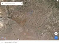
Hey MM, Your not the only one trying to figure out what's going on here. This image is about 154 miles of from Morenci, AZ.
Turned out the dry lands are easier to work with for a beginner.")
Been playing a bit with GIS and sattelite images. (learning curve for GIS is horrible!)
I believe I'm getting so far as to be able to find at least concentrations of limonite. Still a lot more to explore.
Those "pinkish" areas show where limonite is "leaking" from the mountain downwards.
So at least we know that the iron hat gold can wear can be found from satellite images. Kinda helping to find potential sites.
*Edit: Click on the picture for larger view!

Turned out the dry lands are easier to work with for a beginner.
Been playing a bit with GIS and sattelite images. (learning curve for GIS is horrible!)
I believe I'm getting so far as to be able to find at least concentrations of limonite. Still a lot more to explore.
Those "pinkish" areas show where limonite is "leaking" from the mountain downwards.
So at least we know that the iron hat gold can wear can be found from satellite images. Kinda helping to find potential sites.
*Edit: Click on the picture for larger view!


Last edited: