HQ Ship of the 17 th Lancers ( Dragoons) sank on rocks in 1797

SB,

Thanks so much, I have no clue where ( or what Captain) the Caledonia was based out of. I do however know the crew and Lancers were rescued by the Britannia out of Bristol.

Every single Caledonia afloat in 1796 was either listed as afloat in 1798 according to Lloyds list or a record of sinking nothing to do with our search.

If you have access to facebook messenger I can include you in the thread with everything we know so far.
 

Hawker-Caledonia-3-199x300.jpg

http://www.robertstephenhawker.co.uk/?p=621
 

Last edited:
Page 92,

https://www.bristol.ac.uk/Depts/History/bristolrecordsociety/publications/brs20.pdf

I6 Oct I795 In the Britannia, George Clutsam, master, from
Jamaica
Protheroe & Claxton, 3I7 hogsheads 50 tierces sugar, I5 puncheon
rum, 28 tons logwood
L. & R. Bright,4 45 hogsheads sugar, 3 puncheon rum, I7 tierces
coffee
Munckley & Co. 35 hogsheads sugar John Fisher Weare,s 54 hogsheads
sugar
John Maxse,6 20 hogsheads sugar, IO puncheon rum
W. Fuss,7 3 hogsheads sugar, 5 puncheon rum
Milligan & Mitchell, 20 hogsheads sugar W. Da vis, s 2 hogsheads
sugar
W. Pownall, 9 I barrel sugar Mrs. Lane, I barrel sugar
 

That is certainly the Clutsam in question, having all of that sort of cargo on board 2 years later it seams likely to me he would have dumped the rescued crew and Lancers to a close port.

There is evidence reported in late August in Lloyds list that he arrived in St Nicola Mole ( probably actual arrival in July) where I think he dumped his rescued people or added victuals for the trip to the UK if they stayed with him, arriving Oct 3 rd.

His owner is not going to be happy about his 2 month delay delivering his cargo, so he must have had a very good reason for his tardiness.
 

Last edited:
Page 92,

https://www.bristol.ac.uk/Depts/History/bristolrecordsociety/publications/brs20.pdf

I6 Oct I795 In the Britannia, George Clutsam, master, from
Jamaica
Protheroe & Claxton, 3I7 hogsheads 50 tierces sugar, I5 puncheon
rum, 28 tons logwood
L. & R. Bright,4 45 hogsheads sugar, 3 puncheon rum, I7 tierces
coffee
Munckley & Co. 35 hogsheads sugar John Fisher Weare,s 54 hogsheads
sugar
John Maxse,6 20 hogsheads sugar, IO puncheon rum
W. Fuss,7 3 hogsheads sugar, 5 puncheon rum
Milligan & Mitchell, 20 hogsheads sugar W. Da vis, s 2 hogsheads
sugar
W. Pownall, 9 I barrel sugar Mrs. Lane, I barrel sugar

Did someone say Rum ? ? ?
 

We’ll be drying you out at the stage….or wringing you out at the least.
 

SB,

What a small world we live in, Agflit sent me the very same info via messenger a couple of hours “AFTER” you did!!

Do try to keep up Ag!! Smith Brown is making you look bad!
 

Attachments

  • 469AFE04-F843-4C83-9330-1A55C4890F6D.png
    469AFE04-F843-4C83-9330-1A55C4890F6D.png
    877.8 KB · Views: 60
I defer to Smithbrown unequivocally.... I am a simple minded dolt in comparison to his ability's and resources....

and SB...thankyou for that info....
 

I think you picked a very tough nut to crack, but thanks for picking the nut.

The 17th was extremely active during the American Revolution. It can be assumed from available records that elements of the 17th formed the core of "Tarleton's Legion". In my part of the country, that is Big History.

While I realize the regiment's participation in the American Revolution far predates the occurrence of your wreck, nonetheless I thank you for bringing the regiment to our attention.

And, of course, there is the charge of the Light Brigade.
 

Very interesting info forwarded to me by Agflit…….

4AF62AA6-CC50-41CA-BD93-2D6E49BFDFA9.png
 

I watch BBC Escape to the Country on DABL, familiar with that area... they tend to bring out the history a lot.
 

"Ship and Shipwrecks Lists - Nautical Archaeology - Research Guides at Texas A&M University" [url:unhappysmiley:]https://tamu.libguides.com/c.php?g=461106&p=3152733[/url]

Many sources here that could be of use. SADS...can we assume a sailing date from the records we have.....if we have a day of departure, and we know what month she sailed....we should be able to draw a circle around the mole at st Nicholas and know that this boat cannot be any further than the sailing capabilites of the vessel will allow.

Example:
If I know that said boat left on a Friday in June, from the mole of Saint Nicholas, then we can surmise the weather pattern and sailing Conditions. Let's say we have an average trade wind blowing from the east at 10-15 kts. Now this is all speculation but an educated guess could be quite close. If we know that survivors were picked up let's say on Tuesday?? Well now we know that the boat had been underway and sailing for 4-5 days. We can now estimate an average sailing speed for this boat and predict a general location for the reef/Rock that she hit. There will be a limit to how far along she could possibly be, and we would know for sure that the boat could not be any farther than a certain limit that is dictated by her sailing performance. So if we have a departure date, and a date for the wreck and rescue, then we can estimate a location based on the sailing performance of the vessel. If we know the direction of sail, and its average speed over the duration of its voyage we should be able to put it in a general area at the time of the wreck !! Right ??? So how many days at sea before she wrecked, and a general average of the sailing performance/speed should put us in a certain area if we also know the direction she was headed !!


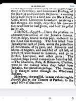
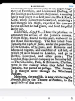
The problem we have Bart as can be seen from the newspaper above is, they all left ( we assume the Caledonia was in this fleet) in mid June and the fleet arrived London early August. Those are the only facts we know.

Now we are reliably instructed the Caledonia foundered on rocks somewhere between Jamaica ( or St Nicola Mole) and the exit of the Caribbean between Mayaguana and The Turks. As the rescue was effected by long boats of the Brittania of Bristol we assume Clutsam was the Captain as he got late back to the UK ( two months) in a Britannia.

He is also reported being at St Nicola Mole end of July, so I assume maybe he dumped the crew and Lancers there or revictualled for more people on board?

Presently I dont even know what country they were rescued in hence my desire for help, advice, guidance, or divine intervention on here?

I am pretty sure Clutsam is our guy in the Britannia but need to get his log, the Caledonias log ( dont know the Captain yet) one of the accompanying warships log or Fuss or Foss who was in the Charlotte of Bristol that broke away with Clutsam??
 

Last edited:
For those who may want to help me get a few artifacts recovered and given to the Lancers museum. Here is a precis of what I know so far.

1. The Caledonia sank somewhere in the Caribbean between Jamaica and the exit of the Caribbean between Mayaguana and the Turks in late spring/ early summer 1797 with the baggage of the 17 th Lancers ( light dragoons).
2. The Lancers and crew were saved after foundering on rocks by the Britannia of Bristol’s Long boats.
3. I think the Captain of the only Britannia in the Sugar fleet was Clutsam or Clutfam as it was spelt then.
4. Clutsam got dropped from the fleet and was 2 months late getting home with his sugar.
5. He was reported at St Nicola Mole ( modern NW Haiti) at the end of July and joined the next convoy to the UK after the one that dropped him.
6. The Charlotte with Captain Fuss or Foss was left behind with him but was only a week late to the UK.
7. HMS Resource, Mermaid, and Canada were the escorts for the convoy that dropped Clutsam.
8. There was no loss of life from the Caledonia and this suggests hitting the rocks in good or not bad weather.
9. Clutsam mentions in a letter being attacked by row boat privateers but nothing of a rescue, this suggests to me he rescued them after leaving St Nicola Mole ( either in the Bahamas or Turks) otherwise he would have mentioned it in a letter home from the Mole before he left there.
10. A Mr Foulkes is reported travelling home from Jamaica on the Britannia, this gives the impression he was a man of importance.
 

Last edited:
Im assuming may-june departure in the first fleet....do we have a time period for the rescue by brittania?? I'm trying to get a feel for how much headway the Caledonia was making up the passage per day. If I can assume what the boats sailing abilities were and a departure date from jamacia....well...then we can get a guesstimate of where this boat should be after a set amount of sailing time.

So a departure date and a rescue date could be of enormous help. Once we have an idea of how many miles she could average in a 24 hour period we could then surmise a general area that she would have been in at the time of rescue !! Does that make any since to anyone ?? The amount of miles this boat could make in a day ? the number of days at sea under sail before the rescue should give us a generalized area at the time of rescue. We know that a early summer departure would put us in favorable trade wind conditions....an east south east trade wind would put us on a starboard beam reach ?? It looks more and more plausible that a north and east drift would push a vessel to the windward side of inagua island.....im guessing but so far im looking at the east side of inagua Island as a likely spot for hitting the rocks !! Im gonna try and find some ocean current and tide info for this area....totally unfamiliar with the tide and current sets for this area !!
 

Hey Bart, thanks so much.

Literally all I know or suspect is above except that I think the chances of hitting a rock or reef are more likely when you get between the Bahamas and the Turks trying to make the Atlantic and deep safe water.

I would love to help more but all I know for sure is the Caledonia sank after leaving Jamiaca ( or St Nicola Mole) and by virtue of the comment about the Britannia of Bristol saving the crew and Lancers after it hit rocks, it has to be before the Atlantic proper
 

Last edited:
Screenshot_20210624-103731_Samsung Internet.jpg
So should we take this date of June 14th for a departure date from jamacia with any serious consideration ??

Hmmmmm....then we are back at the mole end of July !!
 

Last edited:

Top Member Reactions

Users who are viewing this thread

Back
Top