How Old Is That?

Turns out, I messed with the cable camera with a mounted penlight rated at 150 lumens and it can see about 15 feet or so out in front. Thats with 3 , 3 foot extensions, makes it about a 15 foot cable camera with a 15 foot view range. Might work well, however any humanlike bones its a felony not to contact sheriff. Not sure on artifacts, should be ok on that.
 

Last edited:
I'm assuming you found out about the cable being useless for maneuvering past 8 ft, thus the 3-3ft extensions for added cable strength. 3x3 + 6 ft unaided cable on the end holding the cam and penlight....will be interesting to see how you maneuver past any obstructions, deviations in a straight path. Course, maybe ye only needed to go 15 ft., in a straight line. :dontknow:

In any case, don't make any bones about it and keep everything artifactual if yer gonna post it. In situ of course, jest to be safe :wink:

Good luck and happy huntin'. :icon_thumright:
 

Last edited:
I was going to remedy some of that maneuvering with a length of pvc pipe, pretty much work the pipe into a spot on top of fill and then use it to snake and support part of the cable camera. Although , in general , yes your are right, it will be hard to control where it goes from there.

I didn't get back to where I wanted to, snowed pretty big over the weekend. I went and looked for a possible mine I spoke of earlier instead. The markers petered out to it, perhaps pushed down the hill as kids often do that sort of thing. I stayed the direction of the original maker by the trail though, and not far away, ended up at a steep vertical ridge that had a hidden spine of quartz going all the way up and down it into the canyon, shown by scattered surface quartz here and there, also a large vein about a foot wide ledge on the underside of an outcrop just around the corner from the spine. The best stuff seemed to be about midway along the spine as it was a red quartz laced with pyrite that Ill have to crush up and see what's in it. The other quartz was mostly milky white. I may go back and see if missed something that points out a well hidden mine in that hillside or spine. One big possible monument on the hillside though. Looked like a perched giant duck head. I have one of those at another mining spot.

If the snow stays , I may have another spot down out of the snow I'll try to use the cable camera on, kinda of a collapsed section of a vault or something in which I found what appears to be a rocked in entrance and just uphill from it was this collapsed spot in the hillside where there was a deep hole developing. Possibly a good place to poke a pvc tube into and snake the camera thru. I'll probably post it if I can get it done.
 

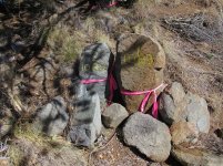
A unique find yesterday. These monuments were erected in 1900 by a US mineral surveyor (carvings enhanced with a lumber crayon). They are two corners of a mining claim, but located only one foot apart. Guess why.

Wedge NE + NW cors.jpg
 

That looks pretty new, like last 5-10 years min. But I can't guess why on the corners. I have some pics of like 100+ year old stuff like that. Obelisk looking stuff with geo survey markers on it from long time ago. But it gives away my exact location. And I don't like people knowing too much about me anymore. The digital age is a know too much about people anymore.
 

That looks pretty new, like last 5-10 years min. But I can't guess why on the corners. I have some pics of like 100+ year old stuff like that. Obelisk looking stuff with geo survey markers on it from long time ago. But it gives away my exact location. And I don't like people knowing too much about me anymore. The digital age is a know too much about people anymore.

The rock on the right, 1-1069, had fallen face down in the dirt many years ago despite half of it originally being buried/propped up 12" on the steep ground. Hence the difference in appearance and relative lack of weather erosion of its carvings compared to 2-1069, which remained upright since 1900. We knew exactly what to look for because we had the Mineral Surveyor's handwritten field notes describing in detail what size rock he used and how it was situated. The surveyors often used a rock about 24" long when they could find one, not because it was an "obelisk", but because it could be solidly set it the ground with the carvings done on the top half.

This sort of information and much more is available (if you care to dig it out [ha ha]) from this website: https://glorecords.blm.gov/ . A very useful tool to help identify not only mining claims but all other surveying activities that occurred on public lands (township surveys, homestead entries, government boundaries, et al). Always print out the field notes if they're available - in addition to technical stuff there's often great cultural and historical information in them too.

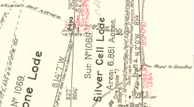
If you are in mineralized/public land country, it's very helpful to know who, why and when many of the rock monuments and carvings you run across were created in the area. By the way, mining law dictates that a claim's endline must be defined by at least two points. Thus this claim, the Wedge, with a "pointed" endline, had to have two adjacent monuments to form the point and make it legal. We've found 700+ corners on Pinos Altos Mountain and environs and this is the first double-monument.
 

A unique find yesterday. These monuments were erected in 1900 by a US mineral surveyor (carvings enhanced with a lumber crayon). They are two corners of a mining claim, but located only one foot apart. Guess why.

View attachment 1909498

The collective would have liked to have saw the site in it's natural state before massive manipulation was done. Some of the conclusions were steep cliff face or wedge.
 

The collective would have liked to have saw the site in it's natural state before massive manipulation was done. Some of the conclusions were steep cliff face or wedge.

No "massive manipulation" here, except perhaps the shafts and dumps on the Silver Cell claim to the east, haha. At these double points, we just propped up the right hand carved stone, which had washed out and fallen sometime during the past 121 years. Other than the mound of stones surrounding the carved rocks, you are seeing the "natural state", a hillside. No cliff face here - just a steep slope (~3:1). "Wedge" is the name of the claim - here's the top pointy corner of it. My point is that it pays off to look at the old surveys and notes in mining country (where gold and silver were found) - lots of questions are answered in this way.

Screen Shot 2021-03-16 at 9.59.17 AM.png
 

Found this food cache yesterday about 400 feet above where the Continental Divide Trail passes through the Silver City vicinity. Nice job. The summer heat has passed, and the first of the through hikers are beginning to arrive for their last leg to the Mexican Border.
IMG_20220927_101740866.jpg
 

Top Member Reactions

Users who are viewing this thread

Back
Top