Help? Ship Wreck Google Earth

My grandfather thinks it was an old coastal steamer that was used as a target ship from the WWII era that broke loose from it's moorings in the gulf during a storm and washed ashore. But there have been so many ships washed up along our coast over the years that this may not be the same exact one.

Either way it would be a fun dive or snorkel but would be a little pricey on fuel running from Pensacola Pass. Just have to pick a calm day with it being right in the surf zone.
 

Hey thanks for that info. I am kinda new to this Google Earth thing. But found out I could Measure distances with it. So a more accurate length is 216 feet long 32 feet wide and it lays about 107 yards of the shoreline. and I do think it would be interesting dive. Its about 30 miles from the Pcola Pass. Who Knows it could be Bowlegs Ship. Rumour has it they never found it. LOL!!
 

Billy Bowlegs ship sank in Choctawhatchee Bay.
 

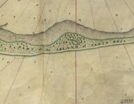
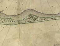
Alot of people get Santa rosa island and Santa rosa bay mixed up !
 

Attachments

  • santa rosa.jpg
    santa rosa.jpg
    24.5 KB · Views: 1,181
  • santa rosa.jpg
    santa rosa.jpg
    24.5 KB · Views: 1,134
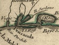
  • pcola forts.jpg
    pcola forts.jpg
    26.2 KB · Views: 1,168
Choctawhatchee Bay? I have not heard that. Just new he ran in this area and that they never found his ship. Chances are that if there were any treasure left it was prolly found in the 60's or its sitting under some multimillion dollar home on Santa Rosa Island some where.
 

You're close. Bud Worth and Capt. Ken White found the wreck in 1958 and cleaned it out.
 

I would think that Billy Bowleg's ship would be considerably smaller. I have no personal knowledge of what he used, however, if I was to pirate this area, I would choose to use a vessel more in the 60 to 80 foot range.
Aquanut
 

You are totally right about the size. The draft alone on a 200 footer, not to mention trying to maneuver it would be a nightmare for a Pirate.
Marco
 

Any updates on this wreck? I got to fly over it in a tourist helicopter and got some video but there were a lot of waves so it didn't turn out that good. The people running the sightseeing tour had some photos where one had shown what looked like either a cannon or mast but couldn't make it out.
 

Any updates on this wreck? I got to fly over it in a tourist helicopter and got some video but there were a lot of waves so it didn't turn out that good. The people running the sightseeing tour had some photos where one had shown what looked like either a cannon or mast but couldn't make it out.

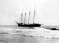
The ship is almost certainly the four-masted schooner Robert L. Bean that was run aground in fog on February 17, 1926. The ship, in the company of a smaller ship, reportedly left empty for Miami to pick up a load of rail-road ties and telephone poles. The Bean ran aground and subsequently set off a flare. The smaller ship (Anne Hall?) thought the flare was the Pensacola light and ran aground herself about a mile away from the Bean. A tugboat was dispatched from Pensacola the next day and succeeded in pulling off the smaller vessel but not the Bean. No one was injured on either vessel.

The site is a four-mile hike from Navarre. The State of Florida owns the land from the high-tide line to the water so it can be accessed even though the other part of the island is controlled by Eglin AFB.

The Robert L. Bean was one of about eight schooners built in Camden, Maine, by the Bean family which are related to the famous L.L. Bean side of the family. It was launched in 1920 and should have had an auxiliary engine fitted.
 

Attachments

  • Robert L. Bean.jpg
    Robert L. Bean.jpg
    24.5 KB · Views: 161
The ship is almost certainly the four-masted schooner Robert L. Bean that was run aground in fog on February 17, 1926. The ship, in the company of a smaller ship, reportedly left empty for Miami to pick up a load of rail-road ties and telephone poles. The Bean ran aground and subsequently set off a flare. The smaller ship (Anne Hall?) thought the flare was the Pensacola light and ran aground herself about a mile away from the Bean. A tugboat was dispatched from Pensacola the next day and succeeded in pulling off the smaller vessel but not the Bean. No one was injured on either vessel.

The site is a four-mile hike from Navarre. The State of Florida owns the land from the high-tide line to the water so it can be accessed even though the other part of the island is controlled by Eglin AFB.

The Robert L. Bean was one of about eight schooners built in Camden, Maine, by the Bean family which are related to the famous L.L. Bean side of the family. It was launched in 1920 and should have had an auxiliary engine fitted.

In trying to find out further information about this wreck, a photo of the launching of the Robert L. Bean can be found by googling "Vessels of Camden". The dimensions of the Bean being launched are the same as the Santa Rosa Island wreck.

Although a newspaper article said that the ships were traveling empty to Miami to pick up cargo, I think that may be an error. Both Pensacola and Jacksonville were ports noted for shipping out lumber. At that time, in the mid-1920s, Miami was undergoing a building boom and there are several photographs older coastal traders being abandoned by their owners in Miami when no return cargo could be employed. I think it is likely that the Bean, a relatively new ship just launched in 1920, was returning empty or with little cargo, from Miami to Pensacola following a delivery of railroad ties and telephone poles.

The Bean was one of the last of the coastal sailing ships and the type was being rapidly replaced by steamships at the time of the grounding.
 

Top Member Reactions

Users who are viewing this thread

Back
Top