Gold Basin Arizona Geology

Clay Diggins

Silver Member
Nov 14, 2010
4,958
14,509
The Great Southwest
Primary Interest:
Prospecting
I was writing this up to help Jeff (Goldenirishman) who is mining in the Gold Basin area. I figured I'd post it here to help anyone thinking of heading to that area.

The geology of the Gold Basin area is pretty interesting for the Geology student and should include a discussion of the Lost Basin/Garnet Mountain geology as well to help understand the groupings there. Since this is an effort to help a placer miner none of that really applies here (explained below) but if you have a further interest in the geology of this region you can find that information too in the referenced reports below.

The geology of the placer gold deposits in Gold Basin are really a story of the epic erosion of the local Colorado River Basin and the long term forming of the Grand Canyon more than any specific local geology that is identifiable today. The placer gold is found eroded and concentrated from the underlying ancient fanglomerates (dry mixed gravels) where they are exposed. These exposures are all within the valley portions of the basin, the mines (gold and otherwise) in the surrounding mountains have no direct connection with the placer deposits in the valley below.

It's often been observed that the best gold in Gold Basin occurs at particular elevations. Of course gold could care less what the elevation is but there is some truth to this observation about elevation. The degree of slope plays a part in the erosional process that first exposes and then concentrates the gold distributed through the older deeper gravels. Higher elevations generally have a greater slope and thus more erosion.

A more useful way to look for gold in the basin is to find where the older gravels are exposed and calculate where those exposed areas will concentrate their gold as they are eroded. With the resources below it is entirely possible to make fairly reliable estimates of where the concentrated gold areas will be found. Each exposure is on the maps in the reports. The older gold bearing gravels are labeled Qgo and the younger non-gold bearing gravels are labeled Qg on the maps.

We've already done that work graphically on our Gold Basin/Lost Basin Footprint map. The areas of gold bearing gravels that are exposed are clearly marked out. Computer Flood Modeling was calculated and added to the map to simulate the huge desert floods that occur every few lifetimes and actually move quite a bit of material. By combing those two factors you can roughly define the areas of greatest gold concentration.

To check this method of prediction we mapped the known historical placer producing areas and found that the predictions closely matched the known productive areas. That's all good but an even better test is to find an area that is predicted to have a gold concentration but has no known history of placer gold. In 2013 my friend Bunk, after defining an area of good potential with his FootPrint map, did indeed find a placer deposit and now has a claim there. Others have done so since.

In short - in Gold Basin find the old gravels and figure out where they concentrated their gold. All the info you need is in the reports below.

The fun part about Gold Basin is it's a relatively new and unexplored placer area. Miners didn't start working the placers there until the late 1930's and work has been light and sporadic ever since. Short of a hard trek in an unlikely area this is probably the closest most prospectors will get to the possibility of a big strike near civilization. As Jeff will tell you it's not all free beer and dancing girls but there is gold to be mined and it's pretty easy access.

None of this applies to Lost Basin/Meadview area. Different geology and different gold deposits just over the hill from Gold Basin. For Lost Basin the King Tut Mine is legendary and very large (pound +) nuggets are still found in that area every year or two. Maybe I'll find the time for that gold geology story another time. :thumbsup:

Here are the resources, I think all of these can be downloaded from the Land Matters Geology Library.

Open File Report 75-93
Preliminary Geologic Map of the Garnet Mountain Quadrangle, Mohave Arizona

USGS Professional Paper 1361 and USGS PP 1361 Plate 1
Geology and Gold Mineralization of the Gold Basin - Lost Basin Mining Districts, Mohave County Arizona

Read the reports they have a lot of good information. You will need all the help you can get in tracking down these widely scattered placers. Until you understand how these particular placers are formed you can spend a lot of time on prospecting unproductive ground.


Heavy Pans
 

Upvote 0
Also, I think it was on your site where I read that if I downloaded the full report from the blm site for a claim, I could get the claim markers, or boundries.
When we look at the first page, only the simple stuff is showed.
Is that how i find the corner markers?

By asking that question, you are where I was 6 months ago... Mr. Diggins and his posts(and others) helped me navigate the whole mess, and your question, though
it seems simple... IS NOT.. What drove me nuts, is folks that have done this for a long time take some things for granted... So trying to understand the GOOD
advice they are giving is difficult.

Here is the short answer... The BLM checks the land status to see if you can have a claim there, then they record the Township, Range, Sections and quadrant, then cash
your check... Though they probably cash the check first... They never check to see if you are overclaimed at all.. They don't care, where I am playing there are tons of overclaimed
lands, some claimed 3 times...

So the BLM and the LR2000 is essentially useless for specific info... Handy to do research on an area, they do generally have the county book and page of the claim.

Now you have to go to the county... They are the OFFICIAL PLACE for claim recordings. When you go there, they don't have a map, they have books of paper...
This is where the info on the LR2000 comes in handy, the book and page... Or if you are lucky, they are modern enough to let you look by Township Range Section..
And if you are really lucky they let you do it online...

So the county can tell you the claim boundaries... No, they just record paperwork... I could put in an affidavit that said I took a good stinker this morning as long as it
was notarized, they would take my $10.. 50 people in a row could walk in and file on the same identical claim, and they would record every single one of them, and take
their $10.... Their job is to record paperwork and help you find paperwork, and in my experience they are helpful with that, but they really don't know a mining claim
from a restraining order, and its not their job to know that.

We're all clear as mud now right???? You've done a ton of research, been to the county clerks, you have a pile of papers in your hand, and you still don't know where the
damn corners are... Placer claims should be Township, Range, Section, and then a notation like N1/2SE1/4NW1/4 or sometimes they eliminate the 1/ and you will see N2SE4NW4...
Now what does all that mean??? I fought with it for a bit.. it describes 20 acres... The North half of the South East quarter of the North West quarter of whatever section you are
looking at. A 40 acre claim would be SE4NW4, and 80 could be N2NW4, a 160 would be simply NW4...

Then of course you have lode claims, I've run into a LOT of placer placed over lodes... Metes and bounds... Distance and direction from a known point... I ran into one recently
that was placed over a placer.. difference being a lode can be 1500 x 600 (20.66 acres, and it can bend to follow the"lode") and a placer must follow the PLSS grid, and a 20 acre is 1320x660.
The one I ran across was simple. From the northwest corner of blah blah blah, 1320 feet east, 600 feet south, 1320 feet west, 600 feet north.

Now you need a map... Landmatters is good, Geocommunicator is the government one... You will need to turn on the PLSS (public land survey or some non-sense)... This will get
you the grid... You can pull coordinates from there, that should get you really close to the corner markers (if they are there).. Some folks put the un official GPS coords on
their claim documents.. I did.

So now you know where the corners are!.. Success!!!!.. No... you only know roughly where they are, the GPS coords and the map overlays are not official...

You need to go out and find the survey markers, they should be at the corners of at least every other section.. Though somebody was arrested recently for
stealing them, making belt buckles out of them and selling them on ebay. Get out the survey tape and the compass and the calculator....
Officially this is where the corners are... I believe that you will be "close enough" to put a stake in with a GPS, most likely more accurate than some dummy with
a half mile of tape measure running over hills and a compass.

Super simple... And honestly its not that bad.. Figuring out how to do the research, and where to do the research, and even what research you need to do
is 99% of the battle. Its a horribly antiquated system, but its what we have to work with, and anybody that likes getting gold doesn't want a bunch of politicians
digging into the 1872 mining law to make our lives easier, because they would screw everything up, just like the do everything else.

Of course you need to know land status... Landmatters (and I finally donated last night) is a quick and easy way to check it out.. Private is white, BLM is yellow,
state is blue, forest is green... Of course that isn't official either... The BLM has their big old maps, and for $4 each, I highly recommend them. Of course that doesn't
tell the whole story either, just today I ran across state land with federal mining claims... I need to dig into it more, it sites some act, but apparently the land was
transferred to the state, but the feds kept the mineral rights, so I *think* I can have a federal mining claim on state land...

I hope that helps a little, it helps if you accept that it really isn't very logical.. It involves the feds, the state and the local governments, and not a single one of them
cares what happens as long as they get their fees.. It is a bureaucrat's dream, you just need to learn how to navigate the mess.
 

Thanks for the long reply.
How do I get the coordinates from the plss.
I know about the township,range,and section and how to figurre those out.
If thats what you mean.
I just want to know how to figure out where the corner markers are so i can tell if a section is all claimed up or not.
I bought Minecache to start with.
And been using Landmatters.
But when looking,it seems that there are less claims, than what shows, and a whole section,that shows filled up,actually is not to me.
But,I could be wrong..

You take all that paperwork that you got down at the county clerks office and start mapping it out. N2SE4NW4... S2SE4NW4.
The descriptions of the lode claims etc... Then see what is left open... After checking the land status of course, you would
be surprised, at least in my area, how many little bits and pieces there are of state and private land.

There really is no "easy" way to "just" figure out where the active claims are... Occasionally you luck out with the LR2000, if there
are no active claims in the quarter section, then you are probably OK to go digging... If there is only one placer claim and it is
160 acres... Then it eats up the whole quarter section and there is no need to go down to the clerks office and pull the paperwork.

On landmatters, as you move the mouse pointer around, it shows the GPS coords down in the bottom corner.. On the GeoCommunicator
you can hit the "i" button, then click where you want to find the coords.
 

Thanks for the help and info bob.
I was wondering about all this because I was looking at a section and it shows filled up,but under the name of the claim, the only one in the section, it has 1 name,but 160 acres with 8 peoples names on it.
So 20 acres x 8 = 160.
But the section shows the whole thing as being claimed, not just the quarter section.
Unless the software is picking up all the claims, closed, and active.
So, I guess I have to go to the blm office and see what is closed for claims to be had, and what is claimed.

Before I forget, where are you seeing the "whole" section being claimed?


Remember up there where I said months ago, I was getting advice, but it seemed like the guys that knew what they were doing were glossing over things
and eliminating details... I'm doing the same thing... BUT... Here is the kicker... If it seems like in an explanation of the whole claiming process, or the looking
up of claims is missing... Its not being glossed over, it really is missing... The whole process is a convoluted mess (that actually sort of works) and there
are a lot of loose and open ends....

So when you are sitting there wondering why the claim question wasn't answered to your satisfaction... Its because there really isn't an answer, or a
definitive simple concrete answer..

Lets Take Clay Diggins, the mylandmatters.com dude... I asked quite a few newbie claim questions, and he always answered(and stuff others asked), and he always aggravated me:BangHead:,
the answers were always vague and not really to the point... So I took what he gave me, and what others here gave me, and my own research and was able
to piece it all together(I think) eventually.. Now that I go back and look at it again.. the vague, not on point for what I wanted to know answers were actually dead on accurate
answers..

The whole claim thing is a giant fluster cluck... Its one of those cases where "you don't even know what you don't know" applies perfectly... Doing the research on claims is
actually fairly simple... Figuring out WHAT research to do.... And then HOW to do the research is the difficult part.... I had a hard time accepting that all this legwork
actually needed to be done... And it needs to be done.. But once you figure out how to do it... Go talk to the nice ladies at the clerks office, have a chat with the land law officer at
the BLM.. Its not all that bad.... I actually enjoy it now.. Pull the plat maps (another thing I thought was a no-brainer, I had to download the cheat sheet), and start pulling the
old paperwork.. Its pretty darn interesting historically...

Accept this... Claims are F'd up.. The claim process is F'd up... The bureaucracy surrounding them is F'd up... The laws about claims are F'd up, governed by
federal and state regulations... Yet for some reason recorded at the local level... Its a fluster cluck of different government levels and laws, and not a single one of
them cares about your claim or your gold, they just record stuff, and collect fees according to some law that was written when it took 6 months to get from
New York to Nevada, if you were moving fast.

Going down to the BLM might get you some info, if you are at the right BLM office... Even they barely know what is going on with claims, they record it, and take your money...

Everything starts and ends at the county clerks office... Its a FEDERAL mining claim, on FEDERAL land, governed by STATE laws(Nevada corner posts have to be at least
3 feet tall... New Mexico, at least 4 feet, just an example) and the COUNTY is the place that makes it all official.. See how clear as mud this is?

You need to go down to the county clerks office... The first time I went up there, I barely knew what I was looking for, I didn't know how they would let me search, I had no idea,
and I was a bit nervous, I didn't even know what to ask them.... They didn't know a mining claim from a jelly donut.... What they did know is how to use their computer system
to help me find documents that they had recorded... I got a personal tutorial on how their 1984 system worked... And I went to town... And then I paid a bunch of money for
a bunch of copies... I later learned they will e-mail them for free... (an e-mail is not a copy). They were all really really nice and helpful... helping me find documents, that is
their job.. What is on the documents... They couldn't care less, that's your job.

My advice, slow down.. Take the time to learn WHAT you need to research, and then take the time to learn HOW to do the research.... Then its a breeze.. Sort of...

When it comes to active and closed claims... The LR2000 is a handy resource... Its a B$@#$^ to use... Its not intuitive, its not simple... I went a month without using it,
and I almost forgot everything.. So now I use it to look up something at least once a week (finding gold, even if you are sitting at a computer, is far better than working)...
You can choose active closed or pending or something else... You just need to worry about active and closed, I've never seen anything pending.... There are quite a few
vids online that explain the LR2000, I recommend any and or all of them, the LR2000 is not something you can go into blind, I tried and failed miserably, watch a few vids...

Take 2 steps back, and learn the process, learn what to research, and how to do the research.. Then you will know where the claims are, where the open land is.. And from
that point staking and filing your own claim is a few stakes and some simple paperwork away. I shouldn't say "simple" paperwork.. There is no official paperwork, you sort
of have to make it up, or find a form from somebody else online, but the info is simple(the claim process is so screwed up, you get to make up your own official claim form)
... Just leave a LOT of room at the bottom for the notary.


Additional thought... 6 months ago, I would have read the words I just wrote in this thread and thought... Why isn't this guy telling me what I have to do???? I am
actually telling you what to do... It really is that open ended, and that convoluted... Nobody tells you to check box A,B or C... Nobody will hand you a pretty map of
where claims are, and what land is open.. The folks at the BLM and county, they can get you pieces of paper, but they don't have a clue what is on them...

Its a bureaucrats fantasy...
And for the rest of us it is a bureaucratic nightmare.
 

I have to agree with Bob that the claiming procedure is pretty messed up with the different levels of government involved in it. If it's a FEDERAL mining claim, why is the state involved in it at all? That's never made any sense to me. I can see local involvement by county but don't most counties have a federal office of some kind?
Another thing that bothers me that I know we'll never see is a streamlining of the claiming process when it come to stating where the corners are. It would cost them way too much to change the system over to GPS cords. The current system of liquid description by the plss system was fine for years but modern tools should be used for modern times. I like to think I'm pretty modern in my prospecting. I use computers a lot and they're a great tool. Why the government hasn't modernized their system is on my because of the cost of doing so.
 

Of course you need to know land status... Landmatters (and I finally donated last night) is a quick and easy way to check it out.. Private is white, BLM is yellow, state is blue, forest is green... Of course that isn't official either... The BLM has their big old maps, and for $4 each, I highly recommend them.

Of course that doesn't tell the whole story either, just today I ran across state land with federal mining claims... I need to dig into it more, it sites some act, but apparently the land was transferred to the state, but the feds kept the mineral rights, so I *think* I can have a federal mining claim on state land...

Excellent answers bobw53. You have learned this stuff in record time. :thumbsup:

I'm writing a piece that will help explain why the whole claims thing seems like a giant "fluster cluck" but really isn't. That should be ready soon but in the meantime I wanted to help your understanding about the land status information on the Land Matters maps.

The paper maps offered by the BLM are old, out of date and inaccurate. Please don't rely on them. The closest you will get to an "official" map of current federal lands status is what is shown on Land Matters. The version on Land Matters is the latest one used by federal agencies and was created by the USGS/BLM on January 1, 2015. It is an exact copy of the one used by the management agencies. As new updates are made available we update the Land Matters maps with that information.

The "Land Management" mapping on the Land Matters maps shows the boundaries of the various surface management agencies jurisdiction. It does not show subsurface ownership or management. That's an entirely different map that we are working with the BLM to create. That map is almost ready and when it's right we will add it to the Land Matters Land Status maps.

Surface management is only about half the area that subsurface management is. The subsurface estate (minerals) was reserved to the United States on most state and private lands. The subsurface areas are often open to claim even though they are on state or private lands. There is a different procedure for prospecting and claiming those lands so don't get all excited yet about making claims on those state lands or your neighbors yard.

Not all surface managed public lands are open to claiming and not all private and State lands are closed to claiming. Little details like that are why we put so much emphasis on land status issues at Land Matters. When the subsurface management maps are live we will need to move on to displaying withdrawals and use restrictions so you can easily get even more information on any location.

Thanks for your donation bobw53. It's good folks like you that keep us adding and improving the information available at Land Matters.

Heavy Pans
 

What made you want to become a geologist? Did you already have gold fever?

I can't think of any other good reason to become a geologist than wanting to find gold.. Then again some people probably find rocks in and of
themselves interesting... Then again, I know a lot of people think the things I'm interested in are stupid.


I've just always had a curious mind about why things are where they are, how did that form or get there. How can places rt next to each other be so different or how can places so far apart be so similar, things like that. I love the outdoors and it doesn't hurt when it come to gold either lol!!!
 

Clay Diggins, I really appreciate your post. I have Paper 1361, and although I took enough physical and historical geology courses in college to understand basics, I find it difficult to understand some of the terminology. I have to google the geological terms to break it down to laymen's terms. This is a very advanced, professional paper, and is not something you can read once and get a clear picture of the geology as a layman. I have been somewhat frustrated that the Lake Mead National Recreation Area has encroached on some very promising locations, but there's nothing that can be done about it. Google Earth is a very useful tool in this area as well, and it's easy to translate lat/long coordinates to UTM on the gps.
 

Clay Diggins, I really appreciate your post. I have Paper 1361, and although I took enough physical and historical geology courses in college to understand basics, I find it difficult to understand some of the terminology. I have to google the geological terms to break it down to laymen's terms. This is a very advanced, professional paper, and is not something you can read once and get a clear picture of the geology as a layman. I have been somewhat frustrated that the Lake Mead National Recreation Area has encroached on some very promising locations, but there's nothing that can be done about it. Google Earth is a very useful tool in this area as well, and it's easy to translate lat/long coordinates to UTM on the gps.

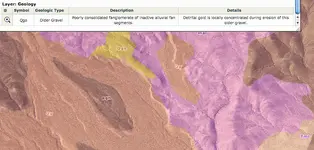
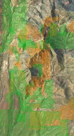
It is a complex report and very complex geology in the basins. As miners that geological complexity is good for mineral potential but a comprehensive report may take a while to grasp. It took us more than three months to analyze, condense and digitize that report into a useable map layer for the Basins FootPrint. Here's an example of what it looks like in color over the top of an aerial photo:

Picture 4.png

The information box at the top of the picture is the result of a query on the "Qgo" geological unit displayed on the map. Essentially a visual access to the results of that report. The user can display the geology layer along with land status, claims and water flow to see where these areas may have deposited gold in mineable concentrations.

Keep studying those maps and reports and on each pass you will have a greater understanding of the implication of how this gold is revealed and concentrated. Every location is different. In one gold could be eroding out of a vein in dry conditions creating an eluvial placer, in another location the gold could be deposited and redeposited into waterways far from the source. In Gold Basin the placer gold is eroding out of older gravels in the few places they are exposed. Gold is where you find it. These reports can really help understand why and where it might be found.

Hint: You can change Google Earth to display UTM coordinates! :thumbsup:
Tools > Options... > Show Lat/Long > Universal Transverse Mercator > Apply

Or you can switch your GPS unit to DDMM (decimal degrees) or (DDMS Degrees minutes seconds). Your GPS (and Google) have the same accuracy whether you use UTM or Degrees - with Google not much accuracy and with your GPS a fairly reliable 30 feet or better.

Heavy Pans
 

Valley Fever is an issue everywhere in the Southwest.

The thing about Valley Fever is that most folks get it and only have a few minor symptoms. After that they are good to go. Most people that test positive for infection never knew they had been exposed. A few folks, mostly older people, Filipinos and Blacks get much worse symptoms. This stuff can be really bad for them.

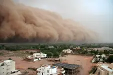
If you are worried about small scale miners getting too much exposure ponder this common wonder of summer life in Phoenix - the dust storm

View attachment 1168875

Just about none of the people in that picture ever dug dirt for a living but they are about ready to try breathing air with tons of dust suspended in it. Jeff will be breathing cleaner air than that even on the windiest days. :laughing7:

The odds of suffering from Valley Fever are really small but they do exist. When mining the presence of any sort of dust can have deadly metals, minerals and sometimes even fungus suspended in it. It's just one of the hazards of the business. It's unwise to work in dusty conditions without a mask for many different reasons. You do what you can to cut the risks.


Heavy Pans

We got dusted on yesterday :laughing7: But not like this one that we got in 2007, I enjoyed being inside that large body of moving dirt (speed of the dust storm: 30 mph !) when I was outside home.
I saw a rainbow of colors without a drop of water :laughing9: Just the moving fine sands LOL

It was a gignatic storm, never seen like that before ! Coverd everything with fine sand/dirt ! They call it (Haboob) in Arabic !
See more here :

haboob (duststorm), a photo from Al Khartum, North | TrekEarth

Giant Dust Storm Blows Over Khartoum -- Earth Changes -- Sott.net

Return of The Mummy? | Daily Mail Online

And you can do a search of "khartoum 2007 dust storm" you will be amazed by your finds :tongue3:

20070501_22_sudan-weather-sandstorm-20070501-131022.jpg
 

This is just awesome information. The reason I convert to UTM is because it is easier to plot a location on my topo map. I'm simply not experienced enough to use lat/long for plotting. Thanks for your very generous help.
 

That 2007 storm dust carried all the way to Denver!
 

That 2007 storm dust carried all the way to Denver!

Haboob (Who bob) lol,
Oh my ! that loong way ! it seems changes in the upper Atmosphere has a large effect on many places on this little planet this century !

One thing for sure, you can't see even your own hands inside that Giant cloud of dust !
A technique to protect you from the fine sand to enter your eyes and nose, is to lay down and take the position of an Embryo inside a Woman's womb. Something like this:

36wkbaby_custom-79a2166d010a668c890c4dd0ccdf0f9df343f868-s300-c85.jpg
 

Last edited:
@ Bobw.
The place i saw the whole section as being claimed up is from the minecache software program.
The way I understand it,but have to email the owner,developer to make sure,is if the whole section,is claimed,it is all yellow.
But when i looked at a section,it is a gpaa claim,with 8 peoples names,160 acres,but it is the only open claim in the quarter section,but the whole section shows claimed.
I went to the lr2000,and 8 people have 20 acre claims.
 

If the whole section is yellow on minecache it just means there is a claim (or claims) in each of the quarter sections.

The minecache program tries to split the claims into quarter sections. If there is just one claim that crosses the center of the section the BLM will classify the claim as being in all four quarter sections. This makes it appear on the minecache display as if the claim is 640 acres rather than the few acres it really is.

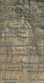
Here's what actual claim boundaries look like:

RHF.jpg

Here's the display from that same area on minecache:

RHC.jpg

minecache doesn't display where the claims are - it only shows which quarter section they are found in. It doesn't show land status either so what might appear to be open to prospecting might be private or state or restricted lands.

Heavy Pans
 

Thanks Clay,that explains what I was thinking and looking at.
Am sending a pm.
 

Last edited:

Top Member Reactions

Users who are viewing this thread

Back
Top