Examples of Superstition Mountain gold

Hiya Springfield:

I think you are probably aware that the meaning of "EL TESORO DE LOS IGLESIA DE SANTA FE" and "EL TESORO DE LOS EGLISIA [Latin-EGLISAS ?] DE SANTA FE", as found respectively on the one Stone Cross and the "Cursum Perficio" drawing/map, have been discussed in the past. Since the translation to English is "The Treasure/Treasury of The Church (Catholic) of The Holy Faith" it seems as though the author of each had something in mind of some value, at least to himself.

Regards:SH.

Exactly. This is why, to me at least, the stone crosses are of at least some interest, whether or not they are modern day hoaxes.

'Holy Faith' was a term used frequently by the early New World clergy. A good example of this is History of the Triumphs of Our Holy Faith Amongst the Most Barbarous and Fiece Peoples of the New World, by the Jesuit Ribas, written in 1645. Of course, this account predated the Jesuit invasion of Apacheria by a generation or two, but it illustrates the use of the phrase.

An earlier use of the term was by the Franciscan Marcos de Niza, in his Relacion, the account of his 1538 expedition beyond New Spain's northern frontier: "where God, Our Lord, could be so well served and his holy faith exalted, and the royal patrimony of His Majesty augmented". Despite his mention of 'His Majesty's patrimony', Marcos's later actions following the 1538 expedition are controversial, bizarre, and still being debated. The Spanish totally vilified him for leading Coronado on a famous wild goose chase in 1540, an expedition that yielded no riches despite high expectations. The Franciscans then promoted Marcos to be their top man in Mexico until his death. Interesting.

Since all these fabulous Southwestern treasure legends are speculative - supported by circumstantial evidence at best, and much of it questionable - here is more speculation to consider. Marcos was present during Pizarro's unconscionable treachery in Peru and thereafter became a very outspoken critic of Spain's sociopathic tactics used against New World natives. Most of his writings were destroyed by Spaniards, but those fragments that remained painted Marcos as a radical champion of the rights and fair treatment of Indians, and an enemy of Spanish exploitation of them while seizing their land and valuables.

What happened in 1538 is mysterious, particularly if you can accept that Marcos would be willing to deceive Spain for a greater cause, such as 'exalting the Lord's Holy Faith'. Let's speculate that in 1540, Marcos sent Coronado north up today's Rio San Francisco to Zuni, whereas in 1538, he actually continued east up the Rio Gila. If Marcos (following Estavanico) did indeed locate a rich and legendary gold deposit on his first visit, his known character indicates he may have been capable of withholding the information from the crown and claim the deposit for the Church - the 'Church of the Holy Faith', if you will. Could he have been a loose cannon, claiming the treasure for God?

Evidence? Rumors, of course. But good ones - a monster native gold deposit that provided monster caches in a variety of locations that straddle the 33rd parallel (Soledad Peak 1, Soledad Peak 2, Caballo Range, Santa Rita Mines vicinity, Gila/Salt vicinity), maybe more. The mystery of the settlement of Todos Santos on the upper Gila. The speculation that the Mother Lode is actually an Aztec site. And more.

The stone crosses? I don't have enough knowledge to offer an opinion of them, but as I said above - the inscription is interesting.

The Peraltas/Santa Fe, NM, connection? I don't see this association with the potential to generate the kind of gold volume speculated in the Kesselring account.

The Peralta Stone Maps? Seemingly something for everyone in them.

San Miguel Chapel in Santa Fe? Built when Onate settled northern NM, still looking for Cibola (even followed Coronado's route into the eastern plains). The oldest church in America. Destroyed and rebuilt. Joe: what else?
 

Springfield,

"San Miguel Chapel in Santa Fe? Built when Onate settled northern NM, still looking for Cibola (even followed Coronado's route into the eastern plains). The oldest church in America. Destroyed and rebuilt. Joe: what else?"

I have dozens of e-mails from one of the Brothers at San Miguel, as well as correspondence with Homar Milford and Al Regensberg from, New Mexico State Records Center and Archives, Archives and Historical Services. I also made numerous phone calls to each of those entities.

The Brother at San Miguel and I became good friends. The information he sent me was extensive so you would be better off to ask specific questions, rather than a general history. All of the information I have is in one place, just have to dig through my STUFF to find it.:dontknow:

Good luck,

Joe

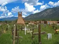
Gosh, Joe, I'm not sure I have specific questions about this church. Thanks for your offer - I'll have to think about it more than I have. I know the Franciscans had a hard time with the Spanish government in Santa Fe and were not welcomed by the natives to any great extent either. Even so, my gut feeling is that, generally speaking, this Order may have had more compassion for the natives than the Jesuits, but who can really say? So much of the history from this time and place is anecdotal. The brothers certainly paid a heavy price in retribution during the 1680 uprising - many Franciscans were hunted down and killed, which by itself is telling. Many Taos Pueblo traditionalists still point proudly to the original church ruins - destroyed during the revolt.

taos.jpg

New Mexico has always been an odd place with a sad and mysterious aura - much different feel than Arizona, IMO. How this all ties into the treasure legends remains an open question. If the Franciscans own large caches in the Southwest, it hasn't been an easy ride for them.
 

Hi

I agree how the " SANTA FE " is not the town in NM and has relation with the Holy Faith . The " COBOLLO " cooperate in the map and belongs to the Holy Faith party .

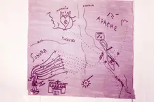
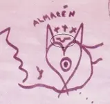
The stone trail map go to a warehouse which has a church treasure . Is the same warehouse with the fox or rabbit heart in the red map .

img131.jpg

Frank

Remember when i asked you why the stone trail is on two pieces ? I will show you why .
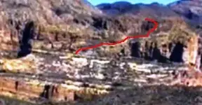
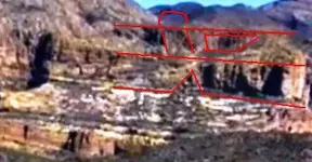
The " DON " trail starts on an abrupt mountainside ( we can see the numbers and the symbols which are in the stone trail map ) and go to the top . Like in this picture

DON stone trail.JPG

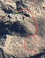
And the Cross stone trail continue above in a plain . Like in this picture

CROSS stone trail.jpg

Are two pieces because are two different directions .

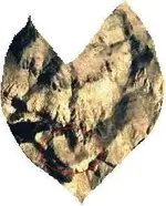
Now , when we are looking from a specific place to the same abrupt mountainside , we can see the Chest Stone Map .

map.jpg chest sone map.JPG

Have a nice day
 

Where did that map come from.
And in a serious question. You post a lot of interesting pics, but do you need a better camera.
They are always or most of the time out of focus.
I would seriously like to see them in actual clarity.
I will buy you one that has auto focus and send it to you, no charge.
I am being serious, it will not be an expensive one, but one that will take better pics than what you are using.
 

RR

Thank you but I have a good camera . The pictures are not clear because are a part of a bigger picture . I can't post the big picture because could be recognize the region . Patience and this day will come .
 

markmar, I commend you on your work, you are very correct in your efforts, keep up the good work. I also would recommend looking at the two maps of the mnt with the crown on top ,
I believe these maps show how things are hidden.good luck. np:cat:
 

Hi NP

Thank you for the kind words . I try to keep up the good work .
 

Ok. If you are using Gimp or Photoshop to crop the pics you can still keep the same ratio even though they are smaller and come out clear.
Unless you don't want them to come out clear at all for your obvious reason posted above.
I understand anyway.
Hope the day hurry's up and gets here.
I may get to old to see things or walk any more.
 

There was a lot of heavy rain back there. I'm in W Mesa and just a few drops. Flooding all around Phoenix last few days. Everywhere but my neighborhood
 

RR

Thank you but I have a good camera . The pictures are not clear because are a part of a bigger picture . I can't post the big picture because could be recognize the region . Patience and this day will come .

Let me ask you a very simple question:

Are those pictures actually yours? Did you take them with your camera or did you get those pictures from the internet?
 

Let me ask you a very simple question:

Are those pictures actually yours? Did you take them with your camera or did you get those pictures from the internet?

deducer

From the internet . If you search for " The site of the stone tablets trail " or " The site of the Chest stone map " , you can find a lot of pictures and links .
 

I wrote in the post #66 :

" The stone trail map go to a warehouse which has a church treasure . Is the same warehouse with the fox or rabbit heart in the red map .

"

I want to explain the upside down Omega sign which is above the fox heart in the red map

sign.jpg

This sign is not accindentally put there but give a principal clue . Is a land shape above the cave entrance . As I wrote the stone trail go ( ends ) in the same point with the fox heart . I post an GE picture with the fox heart in which I marked the region where the stone trail pass , and the fox heart to compare it .

fox%20heart.jpg H.jpg

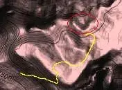
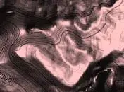
In the GE picture you can see the priest shape in the middle of the heart . Now I will post a topo map which shows the stone trail and the upside down omega land shape at the end of the trail .

Trail and land sign 2.JPG Trail and land sign.jpg

This explanation shows how nothing is accidentally put on a map , and shows how the two maps show the same location .

I hope you enjoyed this
 

And for addition to the previous post , I believe how the handle of the chest in the Chest Stone Map shows the same sign ( the Omega upside down ) .
I believe that because when you look at the landmarks which recognize the Chest Stone Map , the handle is in the same direction with the omega sign .

the chest.jpg The chest 2.jpg

Have a nice day
 

Deducer,

I think the majority of them are Google Earth.

Here's one from near the Pit Mine:

bypass.jpg

Mike
 

I like you guys

The only comments are about if the picture were took from me or if the pictures are fake . You kept the overwrap and threw the chocolate .
 

Top Member Reactions

Users who are viewing this thread

Back
Top