El Nino 2014- Good for us Florida divers or bad for us?

ropesfish

Bronze Member
Jun 3, 2007
1,207
2,046
Sebastian, Florida
Detector(s) used
A sharp eye, an AquaPulse and a finely tuned shrimp fork.
Primary Interest:
Shipwrecks
Surfline's forecast suggests a moderate to strong El Nino event this summer which (they say) produces wind shear that is not good for big wave development in the Atlantic. This sounds like a good thing for visibility and treasure hunting conditions in Florida. Would this be the case or not? Opinions, conjecture or Wild Ass Guesses (WAGs) are welcome.
Here is the link: SPRING EL NINO UPDATE | SURFLINE.COM
 

I think VIZ will be outstanding most of the season.....
 

It's gonna be good for the gulf coast too if these winter storms would quit. It's was 41 yesterday with a 25k wind dead out of the north. Burrrrrr
 

If the El Nino event centers more to the Eastern Pacific, this will cause the Southern Jet Stream to pull further South over the Southern United States and dip across the Gulf Coast and North Central to Central Florida. If this happens, there will be stronger pressure swells along and into the West Coast of Florida which would make visiblity poor to no visibility at all at times. On the East coast, the pressure swells would be away from the East Coast making visibility very high. However, with the Southern Jet Stream dipping this far South, while keeping an abundance of Tropical Systems from developing or becoming threats to the U.S., there is still a chance of increased storms across the Gulf of Mexico and Florida which will definitely stir up the waters and lower visibilities.


Frank
 

You can't rely on the local weather forecast. It's usually wrong. They can't forecast more than a day in advance much less months in advance with any accuracy. The last El Nino gave us great diving conditions on the Gulf coast. I found NOAA weather forecasts from the NDBC site to be the most accurate. I look at Texas weather on Thursday to see what it will be like in Florida on Saturday. Another good weather site is the WLL lightning stations: WWLL Network Global Lightning Locations
 

El Nino years typically give us some of the most "digging days" salvage seasons.

It sure would be great to get more days than the last several years.
There's lots of treasure out there we just need the time to go get it!!
 

You can't rely on the local weather forecast. It's usually wrong. They can't forecast more than a day in advance much less months in advance with any accuracy. The last El Nino gave us great diving conditions on the Gulf coast. I found NOAA weather forecasts from the NDBC site to be the most accurate. I look at Texas weather on Thursday to see what it will be like in Florida on Saturday. Another good weather site is the WLL lightning stations: WWLL Network Global Lightning Locations

In some instances, that can be the case but Weather Forecasting has come a long way and more so in the past 20 years than the previous 200 years or more. The Sciences of the Atmosphere and Weather encompasses every Mathmatical and Physics equation, calculation and solution that you can ever phathom or imagine but yet, it is not an exact science. The reason for that, is due to unknown and unseen factors that can effect weather patterns. Those unknown and unseen factors are generally viewed as a single Thunderstorm or a cluster of Thunderstorms that develop somewhere in the world but if you want to keep into the good olde U.S. of A., then let's say Central Kansas. That single Thunderstorm or the cluster of Thunderstorms which may have developed due to an unknown and unseen temperature discontinuity or an old Outflow Boundary that sometimes will not show up on Radar can and will have an effect on the weather for much, if not all of the Eastern United States. While some may think that the following fact is a joke, I assure you that it is not: Anything that moves air in the atmosphere which includes butterflies, bees, birds, aircraft, etc., etc, and even cars or trucks, make waves in the atmosphere much like the ripples on a pond or lake when you through a rock in the water which move outward in all directions from the point of entry of the rock. However, in the case of things that move the air above, those ripples travel outwards in a more half moon arc in the same general direction of the movement of the object. These ripples grow larger and larger the further away from the event that they get and can have significant impacts on weather patterns. In fact and reality, just one (and yes, I said just one) single Butterfly flapping it's wings in California can effect the weather across much of the rest of the entire United States and will eventually effect the weather across the Gulf of Mexico, the Atlantic, the Baltic Sea, Europe, etc, etc.. When by all foreseen factors, a low pressure system or thunderstorm complex should move Eastward, the factors above can cause them to veer off to the Northeast or Southeast thus effecting and changing the weather upstream from the event and thus the entire previous forecast for specific locations. Now, if anyone wants or thinks that they can forecast weather better than the professionals that do their best to do so, then please have it. I will tell you ahead of time, that besides taking all of the courses and credits to get a Bachelor's or Master's degree, you must have nearly 80 hours alone just in Math, Physics, Atmospheric and Meteorological courses which also includes all of the Calculus, all of the Physics and all of the Trigonometry course that are available. University of Oklahoma | School of Meteorology Core and Major Requirements - Meteorology - University of the Incarnate Word https://answers.yahoo.com/question/index?qid=20100820202849AAB9jiU

You are somewhat right in what you stated! Sometimes you can look at the weather occurring in Texas and predict what the weather will or may be like in Florida in 2 to 3 days. However, that only works if one of those unknown and unseen factors and sometimes foreseen factors does not get involved! If a system moving off Texas and into the Gulf of Mexico runs into a Westward moving Tropical Wave, into a High Pressure Ridge, a developing Low Pressure center, a Temperature Discontinuity or even a cluster of Thunderstorms, then all bets are off and that prediction that you made, will probably be thrown to the wind.

The intensity of an El Nino event and where it is mainly centered, has significant factors on the weather and visibility for both the West and East coasts of Florida. If the El Nino event is centered more to the Central Pacific, then the Southern Jet Stream will stay further North and there will be little if any impact to the water visibilities on the West coast of Florida as a result of less Pressure Swells. However, on the East coast of Florida in this type of El Nino scenario, Easterly...Southeasterly and Southerly winds and Tropical Waves can advance on the coasts somewhat unabated and wreak havoc on visibilities and divers. Now, if the El Nino event is centered more towards the Eastern Pacific, then the Southern Jet Stream will usually dip further South and the resulting Pressure Swells will churn up the waters along the West coast of Florida wreaking havoc on visibilities and divers, while in turn, will smooth out the waters along the East coast of Florida as the Pressure Swells creates a flow (due to pressure) away from the coast which can also hinder the Easterly, Southeasterly and Southerly winds and Tropical Waves from effecting visibilities and divers.

Last but not least and so that you and others will know, not all weather forecasts come from the National Weather Service. There are a lot of companies and entities out in the world that do their own forecasting of the weather and although most if not all of the data they receive is obtained from the National Weather Service who they would love to replace, some of these companies and entities just can't forecast as accurately as they would hope. Often times, these companies and entities sell their' forecasts to Radio and Television Stations and these forecasts, good or bad are disseminated to the Public.

And so that you will know that I have quite a bit of knowledge in all that I stated above, I worked for the National Weather Service for almost 33 years before retiring on July 30, 2011.


Frank
 

Last edited:
I just watch whatever channel has the hottest blonde, if she's wrong I still got something out of it !!

chuck.
 

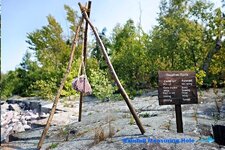
While working for the National Weather Service, being part Cherokee Indian had it's advantages. If storms ever took out the Power Grid and our' Power Generators did not kick in or if communications failed, I could always fall back on the tried and true of my Ancestors.;D


Frank

Indian Weather Rock.jpg
 

Last edited:

Top Member Reactions

Users who are viewing this thread

Back
Top