Eddyville Iowa treasure tale. Could anyone please help determine the exact location?

Crow, the old wagon trail (mormon trail) passed between grays creek and coal creek off the Des Moines river at Eddyville Iowa in Wapello county. The skull was found on the trail. I'm looking for 7 mounds in the vicinity of the location of the trail. Could Bridgeport cemetery directly south, have clues?

Iowa. - David Rumsey Historical Map Collection

Are you referring to the Bluff creek Cemetery?

Crow
 

Are you referring to the Bluff creek Cemetery?

Crow

Crow, Bluff creek cemetery was too far north. I'm thinking it was the oldest cemetery in this area in 1878. There is a railroad directly north, that I assume was originally the. It follows the map directly. is just to the North, and there's is a strip mine to the north east of that.

Location 41.089830,-92.731507

Imgur

Map of Iowa in 1852

Iowa. - David Rumsey Historical Map Collection
 

Last edited:
Crow, Bluff creek cemetery was too far north. I'm thinking Hickory Grove Cemetery, it was the oldest cemetery in this area in 1878. There is a railroad directly north, that I assume was originally the Mormon Trail. It follows the map directly. Miller Creek is just to the North, and there's is a strip mine to the north east of that.

Location 41.089830,-92.731507

Imgur

Map of Iowa in 1852

Iowa. - David Rumsey Historical Map Collection

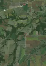
Okay I can see two Cemeteries Circled in red. The road north of these was the alleged site of discovery of the skull marked X. Perhaps the wood along the creek in between the road and cemeteries marked in yellow? Still just stab in the dark and hell of a large area to search.

eddyville 3 jugs of gold treasure site.jpg

The cemetary established in 1878 existed, just when Black hills gold fields were in there heyday. So its not impossible?

I have found some thing else that might be of interest.

Crow
 

Last edited:
Hello BeauS

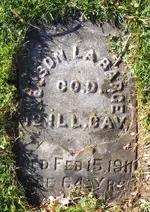
I am not certain as there is always dangers in assuming too much. However Searching through Archival records there was LA Barge who died in 1911 Illinois. Who was a Civil war veteran and miner. If not beyond the realms of impossibility that he was once a miner in the black hills around 1878 and the la Barge of legend and author of the letter. Of course proving it is another matter.

la barge 1911.jpg

Crow
 

Okay I can see two Cemeteries Circled in red. The road north of these was the alleged site of discovery of the skull marked X. Perhaps the wood along the creek in between the road and cemeteries marked in yellow? Still just stab in the dark and hell of a large area to search.

View attachment 1131242

The cemetary established in 1878 existed, just when Black hills gold fields were in there heyday. So its not impossible?

I have found some thing else that might be of interest.

Crow

Crow, check out Hickory Grove Cemetery, you'll see three pyramids. I don't they have anything to do with the legend though, they were built in 1939 Midwest Pyramids: One Mans Artistic Craftsmanship by mojorison on DeviantArt

Do you see a trail just to the south of the timber you circled in white? I think that used to be the mormon trail.
 

Hello BeauS

I am not certain as there is always dangers in assuming too much. However Searching through Archival records there was LA Barge who died in 1911 Illinois. Who was a Civil war veteran and miner. If not beyond the realms of impossibility that he was once a miner in the black hills around 1878 and the la Barge of legend and author of the letter. Of course proving it is another matter.

View attachment 1131243

Crow

Crow, his name was Nelson Labarge, don't know how you discovered that information. https://familysearch.org/pal:/MM9.1.1/FSTF-54H
 

Hello BeauS

When ya been researching treasure legend 30 odd years ya kinda learn one two ways of finding out things.:unhappysmiley:

What would be great for you if you could get some more detailed information, perhaps from the descendant of De Long?

Crow
 

Hello BeauS

When ya been researching treasure legend 30 odd years ya kinda learn one two ways of finding out things.:unhappysmiley:

What would be great for you if you could get some more detailed information, perhaps from the descendant of De Long?
 

Last edited:
Crow, I found a descendant through some research. I see he's got some relatives that might have some information as well. xxxxxxxxxxxxxxxxxxxxxxxxxxxxxxxxxxxxxxxxxxx
Hello beauS A little tip from an Old Hand. Never give out the telephone contact numbers in public on Forum. The very person you want to contact for more information may be already pestered by people. who have read this online. So I suggest you delete the link and Keep it for yourself for now. There is an old saying never play all your cards at once.

But doing okay ya learning....


Crow
 

Last edited:
Crow, I deleted my post. You might have to edit your post and remove that quote so we can keep that information hidden.

I'll see if I can get anymore information about the old postmaster. I need a more pinpointed search area and not just a shot In the dark.
 

Crow, I deleted my post. You might have to edit your post and remove that quote so we can keep that information hidden.

I'll see if I can get anymore information about the old postmaster. I need a more pinpointed search area and not just a shot In the dark.

Yes. One of the problems of such treasure is a century has passed alot of land clearances and farming has happened since then. The Key for you is to get a Copy of the original letter. Good luck and all the best with your search.

Crow
 

Senor Crow, our black feathered one, points out some very helpful info……be very careful what you post…….pictures can reveal data which will reveal location and dates, giving too much info may result in people using your info, and do not forget that certain gov types likely follow at least some of this for their purposes……..
As our black bird says, be careful what you post, there is much to post, much to discuss, but protect yourself.

Vaya con Dios, viva Christo Rey

I'll listen to you guys, I'm new to this stuff.

Anyway, I found an interesting article from a farmer in 1927. I would like you guys to read this page please. There is information related to this legend on page 4 and page 10.

I'm looking for two graveyards and two oak trees to the north. From the two oak trees and after 100 paces there should be several long troughs and corresponding ridges. At this spot the body is buried. On this spot as a corner, a square is constructed, ten paces on a side. Each corner would be $10,000. There is a lot of information in this article. By paces, they mean steps?

Anyway, I plan to try and get the 1903 at a historical library.

Wallace's Farmer 30 December 1927 ? Illinois Digital Newspaper Collections
 

Last edited:
Yes. One of the problems of such treasure is a century has passed alot of land clearances and farming has happened since then. The Key for you is to get a Copy of the original letter. Good luck and all the best with your search.

Crow

Crow, I believe I've found the area. check this out. How would you form the square from the ridges and troughs?

Imgur

Imgur
 

Last edited:
Looks good. Just one thing those dam landmarks are they more recent or much older?

Crow

Crow, I believe those landmarks were there since 1878. How would you map this out?
 

Crow, I believe those landmarks were there since 1878. How would you map this out?

If you have a GPS record the closest spot you suspect then grid reference front that spot each corner with each sides of grid 10 steps. flag or mark the corners with stakes and metal detect the area within paying attention to corners. Repeat the process of grids recording their position on the GPS. Until you have searched the area around you starting point. It comes down to slow methodical searching with the detector. Hardest thing of all is finding the correct original starting point.

Congrats finding that newspaper article which gives more details. There is more questions to uncover in regards to la Barge story. I could not find anyone with that exact name and age given at the the time of alleged events.

Crow
 

If you have a GPS record the closest spot you suspect then grid reference front that spot each corner with each sides of grid 10 steps. flag or mark the corners with stakes and metal detect the area within paying attention to corners. Repeat the process of grids recording their position on the GPS. Until you have searched the area around you starting point. It comes down to slow methodical searching with the detector. Hardest thing of all is finding the correct original starting point.

Congrats finding that newspaper article which gives more details. There is more questions to uncover in regards to la Barge story. I could not find anyone with that exact name and age given at the the time of alleged events.

Crow[/Q

Hello Crow,

His name was Jerome LeBarge, I'll keep searching.

"Then he sighted from the middle
of the old road past the two trees.
Behold, at the end of the hundred
paces that the map mentioned, he
found several long troughs and corresponding ridges. This was where the
body was supposed to have been buried and certainly the ground looked
as tho some one had dug for a body."

"On this spot as a corner, a square was
constructed ten paces on a side, just
as the map advised, and at each of
these corners there should have been
at least $10,000."

I'm guessing the starting point is the old road? Or would it be the two oak trees?
 

Top Member Reactions

Users who are viewing this thread

Latest Discussions

Back
Top