DELL

THE MOTHER LODE

I'm picking up more information about the Two 1715 Shipwrecks I believe are on the South side of Sebastian Inlet. This one is for the Boys with the big serious toys. The Mother Lode of the second wreck appears to be close to the Inlet in about 35 feet of water, and under 20+ feet of sand. I count 65 chests of Gold Coin ( about 8000 lbs.) This is Not in the 1715 fleet listed lease area, but if artifacts are found it the lease area might be extended. If anyone who has the Salvage heavy equipment is interested please feel free to contact me for the location.

It's going to take awhile to plot all the locations of Treasure, cannon, anchors, and artifacts but when I am finished it will provide an overview of the scatter pattern of each wreck.

Several major treasure spots have been plotted so far but none look easy because of a heavy sand covering. As I work farther South, I'm sure I will pick up some pockets of scattered coins that will be more readily accessible for smaller boats. I'll post those locations here (It's Free) as the information becomes available to me.

I picked up the Salvage camp for wreck #2 with several chests of Gold & Silver coins buried on the beach and about a ton of Gold bars buried between the Dunes and A1A. So far Ship #2 appears to have been carrying more cargo of Treasure than the Cabin wreck. It was very wealthy. Any researchers have any Idea of the names of these two ships? Dell
 

Last edited:
Since when has bat sh** crazy meant trouble-maker? :occasion14:
 

FOOD FOR THOUGHT

The Sebastian Inlet area is becoming more interesting. I'm picking up another Spanish ship carrying Treasure, that was engaged in a gun battle with Pirates, circa 1762 and lost. This wreck lies out just beyond the Stern Castle of the #2 1715 wreck. The cargo consists of around 30 containers of Gold Bars, 3500 lbs of Silver Bars along the Keel, and about 2000 lbs of Silver coins.

In addition, in a bit shallower water at least one British ship, maybe more, of 1800's vintage that appears to be fairly intact with as much as 100 lbs of Gold coins, and 50 lbs of Silver coins on board. There are plenty of Iron cannon, so this location should fairly easy to detect with a Magnetometer. IF, I am correct this would be proof, and a good marker for locating the Spanish wreck's Mother Lode. Dell
 

Dell,I am drooling now...
 

Me too! Being bed ridden every day is not a lifestyle I am happy with. I have the experience and ability to find shipwrecks, I just need to be out there doing it. Dell
 

I'm picking up more information about the Two 1715 Shipwrecks I believe are on the South side of Sebastian Inlet. This one is for the Boys with the big serious toys. The Mother Lode of the second wreck appears to be close to the Inlet in about 35 feet of water, and under 20+ feet of sand. I count 65 chests of Gold Coin ( about 8000 lbs.) This is Not in the 1715 fleet listed lease area, but if artifacts are found it the lease area might be extended. If anyone who has the Salvage heavy equipment is interested please feel free to contact me for the location.

It's going to take awhile to plot all the locations of Treasure, cannon, anchors, and artifacts but when I am finished it will provide an overview of the scatter pattern of each wreck.

Several major treasure spots have been plotted so far but none look easy because of a heavy sand covering. As I work farther South, I'm sure I will pick up some pockets of scattered coins that will be more readily accessible for smaller boats. I'll post those locations here (It's Free) as the information becomes available to me.

I picked up the Salvage camp for wreck #2 with several chests of Gold & Silver coins buried on the beach and about a ton of Gold bars buried between the Dunes and A1A. So far Ship #2 appears to have been carrying more cargo of Treasure than the Cabin wreck. It was very wealthy. Any researchers have any Idea of the names of these two ships? Dell
"I'm picking up more information about the Two 1715 Shipwrecks I believe are on the South side of Sebastian Inlet."

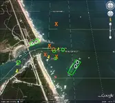
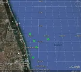
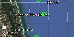
I posted a GE map once on T-Net for that area, from what I can remember had a lot marked in there, Teleprospector was picking up things also.
 

I'm sure the ones I'd do now could be much better, these are older maps. Maps here are what Teleprospector marked over.
 

Attachments

  • SB_2aRDdowsed.jpg
    SB_2aRDdowsed.jpg
    174 KB · Views: 113
  • SB_RDareadowsed.jpg
    SB_RDareadowsed.jpg
    155.6 KB · Views: 105
  • SB_RDareadowsedcrop.jpg
    SB_RDareadowsedcrop.jpg
    21.2 KB · Views: 96
Last edited:
"Gold bars buried between the Dunes and A1A"

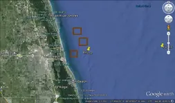
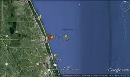
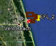
Here are 2 maps I did, more recent ones done in April 2014. This search was only for copper or copper chests.
 

Attachments

  • EFL_2.jpg
    EFL_2.jpg
    114.7 KB · Views: 104
  • EFL-treasurecoast.jpg
    EFL-treasurecoast.jpg
    112 KB · Views: 102
  • EFL-treasurecoast2.jpg
    EFL-treasurecoast2.jpg
    57 KB · Views: 99
Last edited:
Red Desert, The locations will have to be better defined using a much larger scale to be of benefit to Salvors. Even an area as close as 100 feet diameter which is probably as accurate as I can do with the photos available, is still a large area to have to search by blowing individual holes in the sand which may give you a 5-10 foot search area at the bottom of the hole. There is still a lot of luck involved in hitting the exact spot where the Treasure is located. However, I have found that a specified search area is definitely an advantage over random searches.

The angle of the photo, and the size of the photo, or chart will determine the accuracy of the plotted location. As a rule of thumb, jf the scale is 1 inch = 1 mile, then I can be as much as a mile off the target. If the scale is 1 inch = 1 foot, then I can be as much as a foot off the target.

Another thing Salvors, or land Treasure searchers have to consider, is that Google Earth coordinates probably do not coincide with the GPS they have on the boat, or in the field. Dell
 

Last edited:
Yes, GE has to be centered or the angle of perspective changes. I've tried moving an area around in GE to see what happens with the pins, it can look really different as dragging from one side, up or down.

I only have one shipwreck "Salvor" diver to do maps for, most of them are charts because for some reason, he can't get the GE coords to match up in the mapping software. So, the actual maps I do which get checked out, will be charts that cover only a very small area.
 

Last edited:
Right back at ya..
 

Merry Christmas Dell!
 

Hope you find some silver & gold in the healing waters of the Treasure Coast.

Merry Christmas!
 

glad to see your feeling a bit better --posting at least
 

HAPPY NEW YEAR TO EVERYONE!


Unfortunately, not everyone's New Year, starts off on a happy note. Yesterday, I met a kind young man driving a Toyota Camery, make a wrong split second decision with consequences that dramatically affects him, myself, and several others, and could have cost him, or another person's life under slightly different circumstances.


I was driving my 1987 Dodge Camper Van heading home from the Doctors and the Pharmacy after picking up my pain medication prescription I could have chosen to go home thru town, or miss the city traffic lights and go on US Hwy 27. This route I chose was Hwy 27.Two of the Pharmacies I went to had run out of their allotment of pain medication so I was over two hours late returning home. Fate?


As I approached the intersection of State Road 544, I slowed down to 35 MPH and entered the Left turn land. There were no cars in front of me, the lane was clear, and the light was Green. I was almost to the intersection when I knew I had hit, or run over something. There was the crash I never saw coming, flying glass and Plastic, and the windshield broken. The Microwave came flying from the back and landed beside me, missing my head by about 10 inches. I was stunned, I had no idea what just happened but I knew I had hit something and was in serious trouble. I never saw any obstruction in the left lane and could not understand what had just happend. Did I momentarily black out and miss something? I am a careful driver, I haven't had an accident in 40+ years. and then I was not at fault.


As I got out of the Van, a really nice, polite young man approached me to see if I was alright. He apologized, and said this was his fault. He made a bad decision to pull into the left lane while waiting in traffic for the light to change in straight ahead lane. 3 vehicles were involved in the crash. A Jeep had the left door damaged where the Toyota was thrown into the drivers side from the impact. We were all very fortunate that no one suffered any noticeable physical injuries from this accident, but I can't help but feel sorry for this nice young man and how it adversely affects him and his family this new year. A lot of additional expense, and an accident filed in his driving record.


Yes, it presents a lot of additional problems for me , having no money, unable to work and no income except $730 a month Social Security. Now, I am without transportation and no means of resolving the situation at this time. He is covered by Geico insurance but the damage cost is more than the Van is worth, and considerably less than the replacement cost. I have some extra challenges to face this New Year, but I am so grateful that no one was physically injured in this in incident.


Where there is life, there is hope. I wish every one a healthy and happy New Year. Dell
 

Dell, Happy New Year. Please PM me your address. I want to send you $50 . It isn't much, but I want to help, now that I'm working part time.
 

Top Member Reactions

Users who are viewing this thread

Latest Discussions

Back
Top