Thanks to all for the replies and interest in this post. Another image of the strange surface feature is provided here, Google Earth again, but viewed from a different compass direction.

From this angle, two pits are visible. The larger pit seems to have an excavated "ramp" leading to its bottom to make access easier.
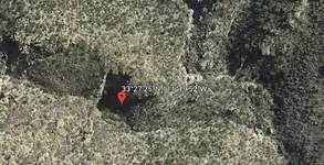
Now, for an added "bonus", here's more interesting Google Earth images of Deering Canyon. The pushpin marks the location of Robert Kesselring's candidate site for the Lost Dutchman mine.

And a zoomed view below. Notice the ledge on the right, covered by the overhanging cliff face. On the left, notice the outflow of dirt/rocks from what looks like a natural "tunnel." Below, on the canyon floor, are potholes, or "tubs", in the bedrock, that will act as basins to catch rainwater. Very interesting geological formations, worthy of exploration, even if it is not a prime site for the Lost Dutchman Mine. Some boots-on-the-ground photos of these things would be appreciated.