hunter_46356
Hero Member
- Feb 12, 2012
- 502
- 306
- Detector(s) used
- NOx 800, AT Pro
- Primary Interest:
- All Treasure Hunting
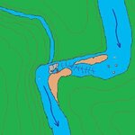
This is my best attempt at a pic of a section of creek where I have found gold. Since I was unable to figure out how to add text I will try to explain what isn't evident by the picture. Current is obvious by arrows, and slower water is above and below the riffles. the red X marks where I've been prospecting and moving over two feet of overburden .The grey represents exposed shale type bedrock which continues under water and the gravel bar. With limited equipment I'm able to recover a couple hundred pcs. of small flakes a day. Digging. classifying and running it thru a small Mackirk sluice. The upper gravel bar revealed only very fine flour when tested but bed rock was never reached. Before the first gravel bar and after the second the water is slow. The water slows below where I'm working and at the bend. The far side of the creek is exposed sand stone and shale. There is a cut through this farther down stream that I've yet to test. I'm thinking of working a little upstream closer to the beginning of the bar with the thought the bigger gold would drop out there but the over buden is deeper. Any suggestions would be welcomed.


Upvote
0


