Caballo followup - stone maps?

Attachments

  • Organ05[1].jpg
    Organ05[1].jpg
    68.3 KB · Views: 1,643
The light colored lines
Look to be natural, a vein of some sort of material
The Dark strain looks to have been caused by water, slowly flowing down the rock
Water frequently does this
Usually caused by a small "spring", a "seep"
The bluish green & the yellow are a type of lichen (Growth)
 

Goldseeker 7

I've responded to your original query in a roundabout way here:

http://forum.treasurenet.com/index.php/topic,152539.0.html

Your Dad was very considerate to do a rubbing of that rock, it's one of the least invasive to duplicate the contents of this type of writing.

This is probably/perhaps (?) Coahiltecan writing which is very surprising considering it's location. It is almost certainly not Apache nor Anasazi, both of which I would have expected considering the geographical location.
 

cielosauce
It is such that from clovis forward is in the area of the caballo mnts. Have seen writing that is at least jay bajada period as well as even posible olgam. Speeling..
Oh well, lol. looking at such with that idea of natives to the area it is such that the marks being canyons and work areas etc make for some reason.
 

LostCauses:
Is your mention of:
"Olgam"
In reference to "Ogam" writting?
"Ogam", of course, is "Celtic" (writting) in origin, thousands of yrs old! :tongue3:
AND!
Yes!
It is found in and around and up & down the Rio Grande River
& Southern/Central New Mexico
There are perfect examples of it, "Ogam", in "The Rincon Mnts",
ie:
the very southern end of The Caballo Mnts!
I mention this "Ogam" site, "The Rincons", because it is easily visited/viewed !
Of Course, You might have noticed my phrase of "Thousands of Years old "
Yes!
This Predated, "Old Chris" by some 2000 yrs or longer ! :tongue3:
But!
It's right there in plain sight! :P
 

cptbil
It is such that a lot of stuff happened before chis. ROTFLOL.

A dot slash or dash system of writing may be such as to a basic usage across a lot of years. It was just a simple way of marking a name or other information.

the reason it took years to even think it was a form of writing is it was a common thing to be seen.
 

I'm not real knowledgeable on the low land Indians. If I recall the Coahiltans were coastal into Mexico? Anything is possible though and over the thousands of years they probably all followed the Rio Grande and had been everywhere. I do believe the pre-Aztec were New Mexicans at one time. They followed the Sun south to find out where it went every fall, and ended up down there..
Down past Judge Roy Beans place Dad went with some buddies to go jug fishing on the Rio G. He found a cave there up a bluff that had several stone metate's and a Sabre Tooth in it, with marked up wall. That was back in the 50's and such just wasn't as big a deal, so he left it there and was gonna go back later; never did.
Might have been Coah's.
The stone I posted was found in the Caballos foothills out in the open and was probably displaced. It is fairly soft thus I don't know if it would have survived the elements for more that a couple hundred years, but it's sure possible.... thanks for the reply.
G7
 

Reply to Captbld topic #63 Posted symbol...from my experience it looks to be a marker to church treasure or next sign.... follow the arrow and the three (3) hash marks would either 3 varas or 3 leagues ( a league 2-3 miles each). That is....If the sign is Real or is it someones idea of laughing at the rubes...looks to be rather fresh for something hundreds of years old....I'd be real suspect!

Has anyone seen and old NM map or know of a renamed a lost Canyon.... name of.... "Cable" Canyon.
My web site:
http://lostloot-treasure.com/
 

The 1996 USGS 7.5' Topo that I have shows it as "Flordillo Canyon" with "Bat Cave Canyon" to the North. Of course, it's really "Cable Canyon" to those around here. In Cable you have to go up through the crack to get above the box canyon where the cable goes; or at least that's what I remember from years ago when the "Property of the US Army" boxes were still stacked under the big Cedar. Worth a visit to the area just to see Bat Cave close up.

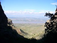
Update with 2007 picture at box end of Cable Canyon looking due West toward Caballo Lake and the Black Range.

P1010386.JPG
 

Last edited:

Top Member Reactions

Users who are viewing this thread

Back
Top