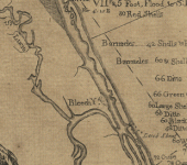
bernard romans map

Attachments

  • bleech yard.gif
    bleech yard.gif
    76.2 KB · Views: 1,317
I guess y'all have read Frogfoot's "Mystery Ship."
http://www.treasureexpeditions.com/MysteryShip.htm
The controversy among modern day salvors is seeded in an old chart drawn by Bernard Romans in 1774. The chart is of the east coast of Florida, with a notation near the inlet at Sebastian " Opposite this river perished the Admiral commanding the Plate fleet 1715...the rest of the fleet 14 in number between this and ye bleech yard". the "bleech yard" is located at Jenson Beach, on the side of a hill, and is a sand patch where sailors would lay out their sails to bleach in the sun. It is a very prominent landmark that can bee seen from the ocean. This is 30 miles south of the Ft. Pierce inlet. Some salvors claim to have a copy of an old chart with the 1715 sites located on it, but the author has never seen the chart and cannot determine how far to the south the sites indicated on the "chart" are located. So, in some circles of the salvage community it is considered a very real possibility that the Urca actually sank opposite the St. Lucie inlet, and not the Ft. Pierce inlet. To add fuel to the controversy, Lima stated that "My ship is at Palmar de Ayz in 27 degrees, 15 minutes latitude." This would put the Urca very close to the St. Lucie inlet.
 

Top Member Reactions

Users who are viewing this thread

Back
Top