Any leads in Southern California specifically Sespe mountains

Hey tapoutking,

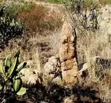
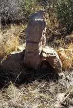
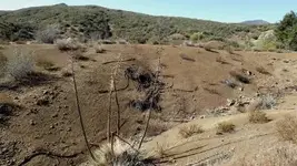
Went back into the Sesepes today to photograph the trail/treasure markings that I had mentioned earlier. Bad news, the canyon that the boulder resided in was hit with a flash flood after the fires in 2006 and a 20' wall of water swept it away. For a small, dry creek it sure had a lot of water hit it. I found huge pine stumps 20' above the mean water level that were washed down stream. I did find some additional markers (see photos), but nothing like what was carved in that rock.

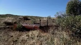
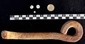
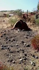
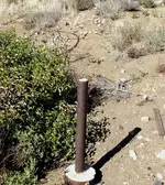
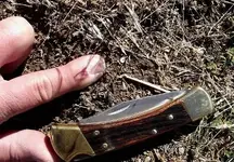
All was not a complete loss :hello2:, I went to the site associated with the Lost Padres Mine and found a few "Mission Period," Olivera shell beads. Since the fire burned off so much brush I found an old oil well that was abandoned and capped on March 6, 1940. This was close by a smelter (ruins) that I took pictures of in 1983 and today.


MISC. 028AB.jpg
THE DAYS HAUL​

MISC. 033AB.jpg
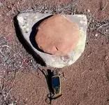
TRAIL MARKER​

MISC. 019AB.jpg
TRAIL MARKER BACKSIDE​

MISC. 020AB.jpg
TRAIL MARKER​
NOT SURE IF THIS IS FOR DIRECTION OR NOT​

MISC. 025AB.jpg
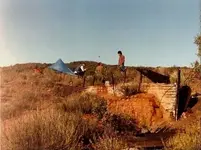
CAMPED AT SMELTER 1983​

1983AB.jpg
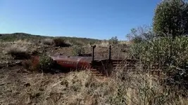
SMELTER 2011​

MISC. 028AB.jpg
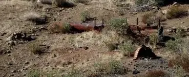
MORE SMELTER​

MISC. 026AB.jpg
MORE SMELTER​

MISC. 027AB.jpg
OIL WELL CABLES​

MISC. 024AB.jpg
CAPPED/ABANDONED WELL​

MISC. 029AB.jpg
CAPPED DATE​

MISC. 030AB.jpg
BEAD IN-SITU​

Well, that is all they will let me post for now,

Had a blast, and it was good to see the Sesepes recover so well from the fires.

H_S
 

Attachments

  • MISC. 021AB.jpg
    MISC. 021AB.jpg
    46.8 KB · Views: 1,057
Awesome man! That trail marker does look like a turtle.... You going to pursue that one?? Good eye on those beads as well! Did you find anything around those smelters?
 

tapoutking said:
Awesome man! That trail marker does look like a turtle.... You going to pursue that one?? Good eye on those beads as well! Did you find anything around those smelters?

Before I follow up on the last marker, I want to follow the dry wash down to the Sespe. I found yesterdays markers at the intersections of dry washes and feel that there are probably more downstream. As far as the smelter goes, there is only fire bricks and slag there. Back in the 80's I did find a placer claim post, but associated it with a cabin that used to be nearby. This was an old trick the Oldtimers used to do to acquire land and build a house. This area is all sedimentary rock with fossils, there are no tertiary gravels around. I did find some whale bone fossils here.

H_S
 

WHAT WHERE THEY SMILTING ? I USED TO FISH THE SESPE CREEK 50'S INTO THE 70'S ONE PLACE NEAR THE WEST FORK THERES A BOULDER IN THE FORK OF A TREE A FORK 20 FEET UP SO LOTS OF WATER COMES DOWN IT FROM TIME TO TIME
 

Hey I'll go with ya into what I think you refer to as the emigdio, of the wolf winds preserve...I am new, and I mean new to metal detecting..My wife bought me one (a tracker iv) and I have yet to receive it but soon... I have camped all through the upper piru, and would love to share what I have with someone willing to try and find the L P.. shoot me an email.. and we'll collabrate.
The Wind Wolves Preserve took the lower part of the canyon now(clue1) We have scouted SEC since the late 70's and still have our family cabin with our deck that looks down into SEC canyon where I sat with my Brother and my late Father with a cold beer planning our day trips down there hunting for the Lost Padre Mine. I can't say how many trips we took down the canyon but we sure had a blast. We were all tired and hungry as we sat around the dinner table each night after a day of detecting and exploring. After big slices of Garlic bread..Wine and pasta dinner, we would sit by the fireplace..poor a scotch "Dads favorite", sit and talk about our day's finds and what it must have been like back in them days. That was the old wagon road from San Pedro to San Francisco.. they did not go by Fort Tejon back then... this route was called El Camino Viejo... also known as the California Mission Trail. We have seen some pretty cool things come out of that canyon ...actually saw some stuff a guy was selling at a yard sale in the area...that was crazy!
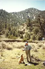
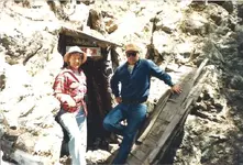
Well, that always ended up with a plan for the next morning to go back again for just the morning ....ha! we always came back late and my Mom would say.. where have you guy's been! we were gonna play golf! emigdio1 (2).jpgemigdio2 (2).jpg picture at the mine 1980's is the start of Emigdio, me and my Mom who is a great sport and always liked our adventures. Picture of my late father on one of our trips down in Emigdio, he is holding a horse shoe he found and thats my old dog Cowboy. I have the pictures of the smelter down there and can email them if you like to see. I have been in all the indian caves and know those mountains from Sespe to Tecuya better than anyone I have met in recent, from years of trail riding, hunting guide, and living there and exploring the old trails that are gone from any maps of today. Most of the old timers are all gone now like old Samuel Snedden who was the first white man to settle in Lockwood and Cuddy valley.
Scout/out
 

Last edited:
I know gold has been found on Frazier mt but what about Lockwood valley and does and know what the mine is high up on Frazier mt it looks as though it had electric lights at one time and smells really bad from near the entrance
 

HI "Tap"!! They call me HOGE, and I took the same leads, (about 81) and started in! We found the Asistencia, and rock signs, leading to where they stashed the 10 yrs, that they couldnt ship. Have we got "there"? Obviously not. Due to age, at this point. As you well know that to cross-over into the Piru watershed is quite a hike. The Asistencia is on the Piru side.
Pls email me @ -- <[email protected]> -- and we can talk.
Im new here, so Please have Gollum get ahold of me also. I can save you MANY miles!....
Sincerely HHH (HOGE)
 

I cant believe that you guys wont even answer.
Ive spent 31 yrs tracing the spaniards in the Sespe/Piru watersheds. Found the Asistencia, and many other signs, including 60foot high Spanish Rock Signs, and finally the "clearing". And you guys wont even ans, when I can actually save you time and effort(= $).
Enjoy yourselves............

HHH=HOGE
 

That "Smelter", looks more like a "Forge", used to do horseshoes, etc. The smelters were built in the banks of creeks.
HOGE
 

Im listening to you..... Ive spent some time in the area, but just out day hiking. I have become more interested now in looking around a bit more carfully. I have a bunch of questions I would like to ask about that place....
HH
Vince
1-17-2013
 

Hillbilly howdy,
Lockwood Creek was full of Chinese miners back in the day, and where Lockwood meets Piru Creek was gonna be the townsite called New Lexington..never was built. We still go to a spot and get Gold every pan off Grade Valley Rd. on the way to Piru Creek. The mine up on Frazier was Gold and the town named after him... you must been riding your bikes on that trail, Great Switchbacks:icon_thumright:
 

Hi scout no I came across the mine deer hunting up there I did not go in cause I have no clue who owns it but there were lights going into the mine I'm not sure when the last time it was used was
 

Man Ive been enjoying this thread! Your talking my launguage with Sespe Creek - Piru creek and lake, and the town of Piru - Fillmore - and goodenoughroad, its great talking to a bunch of like minded fellas that know the area.
I hope this thread can keep going on awhile, Im learning alot more than I ever knew of that place, specially from "Scout" and "HOGE", but all the stories of that area are good reading. I used to have a hiking-panning-and treasure hunting buddie but he moved to Florida 2 years ago, and ive been going nuts trying to find good folks to hike and "look around" that area with.
Could a "Club Sespe" be in the works.. that would be cool. Getting together with other folks who know the area (and the stories) to compare and go over maps with sounds like a great time to me..
What do you all think about actually meeting and talking about this great area?
HH
Vince.
 

Tonight after work, I will try to get some pictures I have of that area, and pics of goodenough road when its in ultra-bad condition. I took my 2 wheel drive E150 Van up there and the road got so bad I actually had to have my treasure buddie to spot me on a few corners.... Now I have a FORD E350 4 wheel drive 7.3 diesel Van and it would be noooo problem..
HH
Vince.
 

Id be happy to sit dwn, over coffee or whatever, and discuss this with you guys. Again ... Security is important, so I can only divulge so much. 2, or 3 folks would be nice. Maybe even Gollum or TapOut? Whomever!
Ive been in the Sespe/Piru area for over 40 yrs, and have a lot to offer, to "anyone".
Ive hunted since 68, from the San Saba Mines, (Menard Co., TX) to FL, (1715 wrecks), to Tumacacori, to Sespe, and in between.
I "can" help....

Sincerely; HOGE
 

if you guys ever have a MEET-UP i sure would come up there its about a hour from here .. I WAS UP BY THERE LAST MO. AT THE END OF HANSLEY CYN . Only a few pennies and a roberts .257 bullet case , but had a great day with my 10 yr old daughter .
 

Hey everyone. I haved been prospecting the San Gabriel river but not for that long less than a year. I really enjoy it but push myself to run more dirt and not enjoy it but either way I like it. I really want to take a trip to the piru creek area. It looks to be the only mountain north of The San Gabriel river before you hit the Sierra's. I read the whole thread but are all the people that commented looking for gold or..... other stuff? Is there gold at Tar creek? Where are you allowed to do it and more important not allowed? Thanks
 

Hey Brookie,

You might want to join the GPAA and get access to claims in your area. I have sluiced S.G.R. many times myself but have many other options and group outings to try out new spots being a member. I like all kinds of prospecting but prefer the detector and looking for the L.P.M. has been a quest I shared with my late Father. Now I have a good buddy who I teemed with for the hunt. I go out to some of our claims in the Dez and get good Gold, also the El Paso range holds nice Gold for detecting also. I go detect a local lake by me during the week..got about 300.00 in gold jewelry last coule times there because I looked and found an old pier there back when the water level was 50 feet higer and guess what, a gold ring with gemstone, gold necklace, gold loop earring! :icon_thumright: Are you River only or Dry Washin? Don't know where your home camp is but there's Gold and relics everywhere. As far as relics same thing.. research your area for history, look at Google earth and scout the hill sides around that Tar creek area for tailing's or old trails leading off to something worth hunting for. GPS the good spots by right clicking and save that reading. Nothing worse than driving somewhere for the day and a week later you find out that you were a mile away from an old mine that you didn't know about. Don't know where that Tar creek is. Piru creek was good back in the 70's and holds Gold but don't know what legal there now. If you want to hunt for relics lower Piru creek for Bandit loot and get out for the day in some nice country, been to the spot with my Dad there where $80,000 in loot was detected and dug up..who knows whats around the next turn of the canyon?


Hey everyone. I haved been prospecting the San Gabriel river but not for that long less than a year. I really enjoy it but push myself to run more dirt and not enjoy it but either way I like it. I really want to take a trip to the piru creek area. It looks to be the only mountain north of The San Gabriel river before you hit the Sierra's. I read the whole thread but are all the people that commented looking for gold or..... other stuff? Is there gold at Tar creek? Where are you allowed to do it and more important not allowed? Thanks
 

Top Member Reactions

Users who are viewing this thread

Back
Top