@greenerlumber - thanks for the post! It really does help to have your guys support. Believe it or not I do know about what you do, I have some very good friends who have a bowl turning studio and have seen the kind of stuff that comes out of those logs. Wouldn't it be weird if they have turned one of your logs? They would love to meet you I'm sure!
I do have a post for you guys. Since we are not mining, we've had a lot of time to explore our claim, so I half heartedly started my search for the long lost Buster Prospect. Since we bought our claims a few years ago, its been kind of a hobby of mine to research our claim's history and previous owners. Back in the early 1900's our area was worked by a couple of guys named William Fairman and John Madsen. They had a big hydraulic operation on the claims above ours but they also staked a few hard rock prospects.
The two on my claims were the Yellow Jacket and the Buster. I am fairly certain that I know where the Yellow Jacket is, the old guy we bought the claims from told us he was driving his tractor up the river one day (cause you know, they did that back then) and saw an old tunnel and opened it up with his tractor. I think I have found that spot, I'll get a picture for you guys, the tunnel is collapsed though. The other one, the Buster, I've never been able to locate here's an excerpt about it:
The Buster prospect is on the left bank of Quartz Creek about one-eighth of a mile below Devils Creek. The country rock consists of sheared slate and graywacke that generally strike northeast and dip northwest. Little or no fault gouge occurs on either the footwall or hanging wall of the vein. The vein consists of vuggy quartz and massive or crystalline arsenopyrite. Some small stringers of quartz are in the footwall slate. These stringers, when crushed and panned, contained free gold (Martin and others, 1915). No assay results are reported for the main vein. The Buster vein was exposed in an open cut 10 feet above the stream level.
Another report from the 1980's USGS said they couldn't find it when the geologists were looking for it.
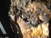
Anyway, we were picking berries in this canyon that we call Fern Gully because it looks kind of jungle-ish. I looked up at the canyon wall and I realized it looked like maybe someone had dug along it and then the hole had filled in with stuff that sloughed off from above. It was about the right location from Devils Creek. We climbed up there a ways, moved some moss, and what did we find but a great big quartz vein! You can also see from the picture in the middle there is a gray crystalline substance, I'm no geologist, but I'm betting its arsenopyrite. Maybe I've found Buster? Is it a new vein? I'll have to explore it more next summer. I may go get some samples and have them assayed. The claim where Fern Gully is located is actually one of two we have that is actually filed as a hard rock claim (probably from when Fairman Madsen staked it back in the day) - a fact that gives the Forest Service apoplexy every time I ask about it. Anyway I'm not really setting out to be a hard rock miner but hey its exciting to find a piece of history.
Back in college, we used to find these reports about these old hard rock workings and then hike out and try an find them. I've never understood how the Forest Service will worry about preserving an old trail or even an outhouse (no joke I knew a guy who had his whole operation shut down so archeologists could explore an outhouse pit) but they will blast in an old mine tunnel or make the claim owner do it without hesitation. Fairman and Madsen had an extensive tunnel on the claim above ours and the Forest Service made our neighbor fill it in because the gate he had over the opening and the no trespassing signs was apparently not safe enough. Isn't a mine tunnel historical? Its a double standard.


