pegleglooker
Bronze Member
- Jun 9, 2006
- 1,857
- 238
- Detector(s) used
- ace 250
- Primary Interest:
- All Treasure Hunting
Just Where is Peglegs Gold
Where exactly did pegs find his black nuggets ? I'm sure if anyone really knows the answer to that... he's not talking.

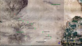
 So let's look at this from what we know.. First of all, we know that Thomas L Smith was NOT THE Pegleg Smith, I must say this first, so that people will know that we are not looking at him, or his stories. Pegleg was a guide out of Yuma Az, and would take people to either Los Angeles or San Diego by way of the old Butterfield Trail. It is assumed that this pegleg worked from the mid 1850's to about the late 1870-1880's. During this time there were several stage lines, Butterfield, Birch, San Antonio and San Diego just to name a few. In Golden Mirages, P A Bailey states that peglegs partner ( a man named Price ) was in Los Angeles when pegs returned with the nuggets. Price stopped the guide work ( the trip before pegs found the gold ) after a job offer in LA, . That would mean if he had gone out the very next trip, he would have been with pegs when he found the gold. Pegs was guiding " a small party ( most likely 2-4 people ) and headed for Warner's by the usual route ". That would mean he did not take off on a NW route next to the sand dunes. The next clue is " They made about 2/3 of the distance to Carrizo without mishap and camped for the night on New river, a few miles east of the Slough Lakes ". That would put them approximately here...
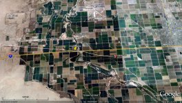
This segment of the route is roughly 32 miles, in other words it was going to be a long day. Because of this, pegleg knew he had to get a early start, but the mules had other thoughts. " They planned to make an early start the next morning and reach Carrizo before it became too dark. However, the mules wandered off, and the party was more than 2 hours late getting under way. " In pegs time, 2hrs was about 4-5 miles in distance, this will be important a little later. The next thing Bailey stated was " About the middle of the afternoon Smith saw they were in for a bad sandstorm, and a hour later it was blowing so hard they could barely make headway against it. It was impossible to keep to the trail, for the blow-sand covered it up or blew away all traces of it in less than half of an hour ( approximately 1 mile ). The outline of the mountains ahead was completely lost, and even the gap leading to Carrizo was so badly blurred that Smith was not sure they were headed for it. " So now we have to " approximate " where he would be, one of the big clues that is missing, is what time of year did they leave. Because, the light on the westcoast can be very long during the summer, however most of the wind storms ( sometimes called Santa Ana's ) usually come during the 1st quarter of the year ( Jan- sometimes April ). Daylight usually lasts about 11-12 hrs, and at 2 miles a hour that's about 24 miles. Meaning, that if they wanted to get to Carrizo before dark they would have to have left about 3 hrs earlier ( and the mules ate up 2 hrs of that ). If we " assume 2-2 1/2 miles " per hr then we can get close to where he might have been. Remember " About the middle of the afternoon Smith saw they were in for a bad sandstorm, and a hour later it was blowing so hard they could barely make headway against it. ", so what is the " middle of the afternoon " 2-3 o'clock ? Ok, lets go with that, if they wanted to leave around 4AM ( it's cooler and better to travel in the morning ) but were delayed by " 2 hrs " . That would mean they would have traveled roughly 16 miles, or roughly here-
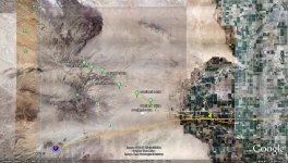
Now the next clue is very important " Instead of letting up as it began to get dark, the wind blew harder. At last it quieted a little ". If this was 2-3 in the afternoon and sunset coming in at about 6, that would mean they should have been close to here-
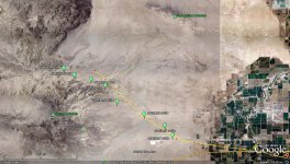
And just barley 3 miles away ( or 1 and 1/2 hrs travel time ) is where the next clue leads us " but it was not until they began to ascend a gradual slope the kept getting steeper that Smith knew for certain they were off course. They wandered into one of those ramp-like canyons to the north of the trail they should have followed. "
Let me introduce you to Barrett Canyon-
Just this past week, I was asked if I wanted to go and check out this area... " aaaa let me think about it..... YES YES YES !!!!!! ". Bruce Huffington was kind enough to take me where I have been DYING to get to and MAN was it a GREAT trip !!!! We went as close as we could get. But I'm getting a little ahead of myself..
The last information is the most important, " Smith told the party to wait where they were and he would go up the canyon a little higher to see if they could cross the hills instead of back-tracking through the sand. He climbed up the ramp for some distance ( I would think no more than 1-1 1/2 miles ) to a small butte; it looked as though it sat on a ridge, so he went to the top, hoping to get a better view of the country.. But he saw nothing except badlands and knew he would have to take the long way into Carrizo. While up there he noticed that the ridge was sorta hogback made by 3 or 4 buttes connected with saddles."
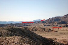
The above photo is how close I got to my " promised land ", it shows where I think pegleg would have scoped out the next course of action. Since WWII this area was used as a bombing range for pilot trainees and as such, is littered with unexploded ordnance. Some of these UXO's are 100lb's, and I just really don't want to bump into one of these ( if you get my meaning )...
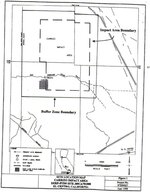
The problem is, this is in the Carrizo Impact Area ( unexploded ordnance ) and not accessible to the public.
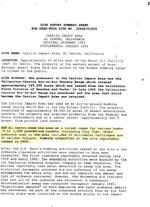
Remember, that Hank Brandt lost mine is nearby, so there has been gold found in this area. But in saying this, I personally feel that the risk is just toooo high to go looking for the end to this story. I do look forward to your thought's on this version of the pegleg strain, and would like to see if there is a agreement or .......
PLL
